Walk #141: Tring Station to Cheddington Station
 |
General Data
| Date Walked | 28/05/2001 |
| County | Hertfordshire, Buckinghamshire |
| Start Location | Tring Station |
| End Location | Cheddington Station |
| Start time | 08.33 |
| End time | 11.10 |
| Distance | 6.1 miles |
| Description | This was a short walk, mostly along the Grand Union Canal. |
| Pack | I did not carry a rucksack today. |
| Condition | Near the end of this short walk my left ankle started aching, sometimes sharply. This is probably down to the injury I did to it whilst I was in Australia a few weeks previously. This is a serious development, and I shall do some more short walks over the next few weeks to see if this is something that needs attending to. Otherwise everything was fine, which was to be expected for such a short walk. |
| Weather | Today's weather was beautiful, with hot temperatures but a low cloud base meaning that the sun did not burn. A light wind also helped keep us cool as we walked. |
| OS map | Landranger number 165 (Aylesbury & Leighton Buzzard, Thame & Berkhamstead) |
Map of the walk
Maps courtesy of Google Maps. Route for indicative purposes only, and may have been plotted after the walk. Please let me have comments on what you think of this new format. For a detailed table of timings for this walk, please see the table file.
Notes
This was a quite nice walk along a picturesque section of canal that was spoilt by a few disappointments. I am enjoying all this canal walking intensely, and at the very least it is proving very soothing to my spirit if not my ankles!
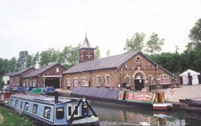
There were many canal boats congregated around Bulbourne, and it turned out to be a canal festival based on the Grand Union Canal Wendover Branch, the junction of which was nearby. The Bulbourne depot of the British Waterways Board looked resplendent with bunting, and many of the boaters had hungover looks on their faces. This depot and workshop is where they make some of the wooden gates for the canal network.
A little further on along the canal from Bulbourne are the junctions with the Wendover and the Aylesbury arms of the Grand Union Canal, of which the former is not navigable and is undergoing restoration. Although it is currently unnavigable it does have water flowing through it in part, as it is used to provide water from the four reservoirs in the Tring area to this, the summit place of the canal. The Wendover arm was opened before the main canal, and therefore for a period was not attached to the rest of the canal network.
As you pass the three locks at Marsworth you pass to the right of Marsworth Reservoir, which was built in 1806 to supplement the water supply to the canal. This reservoir was exceedingly busy when we passed it with anglers at the water's edge, and it made for a very pleasant sight in the sunshine. Next to Marsworth Resevoir is Startop's End reservoir, built in 1817 as the fourth and final of the Tring reservoirs.
At Startop's End Lock there was a nice little caf� which we stopped in to have a cup of coffee and a scone. We got chatting to the lady serving in the caf� and unsurprisingly she reported that the caf� had been very quiet because of the closure of the canal due to the foot and mouth crisis. She also said that she was very worried that many canal-based businesses would go bankrupt because of the closure.
The British Waterways website showed that the entire towpath from Tring to Leighton Buzzard (my intended destination) was open except for a one kilometre stretch between Locks 32 and 31. As I walked I asked a few boaters if they knew what the status of this stretch was it appeared odd that such a short section should be closed. Near Cheddington Wharf there was a British Waterways noticeboard, which showed that the section was indeed closed, apparently due to a history of animals getting onto the towpath.
Because of this I decided to leave the canal at Cheddington Bridge (number 126) and head through the village of Cheddington to the station and regain the canal near Slapton Lock. Although this involved missing out on about three miles of towpath it did not greatly extend the length of the walk.
I found the shortness of this walk highly annoying; partly because it means that I will have to reorganise my walking plans to add the five miles to Leighton Buzzard, but mainly because I am getting very concerned about the state of my ankle. I am probably going to try and do a few more short walks (maybe even in the evening after work now that it is summer and it gets dark later) to test it out.
The next walk that I choose to do will be dependant on the state of the footpaths due to the foot and mouth crisis. The south area of Derbyshire is out due to the closeness of many outbreaks, the walk along the Grand Union Canal is now punctuated by closed sections of towpaths (as we found today), and even my favourite local walk from Waterbeach to Ely is cut off immediately by a towpath closure north of Bottisham Lock. For this reason I shall probably do walks that can fully be completed on roads, starting with the missing section of walk from Darsham to Lowestoft or from Wells next the Sea to Cromer.
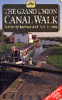
For more details on this walk see the British Waterways website and Jim Shead's canal pages. The walk is also covered in detail in the Grand Union Canal Walk, by Anthony Burton and Neil Curtis, ISBN 1 85410 244 3, published by Aurum Press Ltd.
Directions
This walk starts from Tring Railway Station, which has a large car park which is free to park in at weekends. Leave the car park and turn left to join the road that passes over the railway immediately beside the station. Follow this road for a short distance until you reach the canal at bridge 135.
Before you pass over bridge 135 take a footpath that descends down into the cutting. When the path meets the canal towpath continue straight on to head in a northwesterly direction through a deep cutting with overhanging trees.
The towpath continues in a northwesterly direction on the eastern bank of the canal until Tring Cutting Bridge (number 134), which is a quite spectacular bridge spanning the cutting, which at this point is quite deep. The towpath rises up to meet the bridge, which needs to be crossed as from here the towpath continues on on the western bank for about a kilometre until Bulbourne Bridge is reached. Immediately beyond the bridge is a public house (which unfortunately was shut as we passed), and on the other side of the canal from the towpath are the Bulbourne workshops of the British Waterways Board.
A short distance after Bulbourne bridge a bridge carries the towpath over the short remaining section of the Grand Union Canal Wendover arm. The canal then passes some reservoirs before reaching a bridge under the B489 at Startop's End. Here the towpath crosses over from the western side of the canal to the eastern for a short period until Bridge 131 and the junction with the Aylesbury arm of the canal at Marsworth.
At bridge 131 the towpath moves over to the western side of the canal as the canal turns to head northeastwards past Manor Farm. It then turns northwards to pass under Cheddington bridge (No. 126) just before a bridge under the railway. Leave the canal at this bridge and turn left down the road and climb the hill into the little village of Cheddington. Pass through a village and at a crossroads under some power lines turn right to head down northeastwards down a slight hill to Cheddington Railway Station.
Further information
|
The walk is also covered in detail in the Grand Union Canal Walk, by Anthony Burton and Neil Curtis, ISBN 1 85410 244 3, published by Aurum Press Ltd. Click on the image to the right to go the Amazon page for this book.
For more details on the Grand Union Canal see Jim Shead's canal pages. |
|
Distances
| From | To | Distance (m) | Ascent (ft) | Descent (ft) |
|---|---|---|---|---|
| Tring Station | Marsworth Junction | 2.9 | 52 | 118 |
| Marsworth Junction | Cheddington Station | 3.2 | 75 | 105 |
This makes a total distance of 6.1 miles, with 127 feet of ascent and 223 feet of descent.
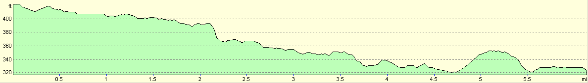
For more information on profiles, ascents and descents, see this page
Transport
There are regular trains running between Cheddington and Tring stations, on the railway line from Northampton to London. There are some local bus services, but none that are as convenient as the railway.
Disclaimer
Please note that I take no responsibility for anything that may happen when following these directions. If you intend to follow this route, then please use the relevant maps and check the route out before you go out. As always when walking, use common sense and you should be fine.
If you find any information on any of these routes that is inaccurate, or you wish to add anything, then please email me.
All images on this site are © of the author. Any reproduction, retransmissions, or republication of all or part of any document found on this site is expressly prohibited, unless the author has explicitly granted its prior written consent to so reproduce, retransmit, or republish the material. All other rights reserved.
Although this site includes links providing convenient direct access to other Internet sites, I do not endorse, approve, certify or make warranties or representations as to the accuracy of the information on these sites.
And finally, enjoy your walking!
This walk was mentioned in the following routes:
| Grand Union Canal Walk |
Nearby walks
| # | Title | Walk length (miles) |
|---|---|---|
| 129 | Dunstable to Tring | 14.1 |
| 130 | Tring Station to Hemel Hempstead Station | 8.0 |
| 143 | Cheddington Station to Bletchley Station | 13.3 |
|
|

|