Walk #746: Welshpool to Newtown
 |
 |
|
General Data
| Date Walked | 29/09/2006 |
| County | Powys |
| Start Location | Welshpool station |
| End Location | Newtown station |
| Start time | 09.02 |
| End time | 14.16 |
| Distance | 14.7 miles |
| Description | This was an easy walk, following the Montgomeryshire Canal southwestwards from Welshpool to Newtown. |
| Pack | Today I carried my 30-litre Karrimor rucksack filled with my waterproofs, three litres of water, and various other odds and ends. |
| Condition | The underside of my feet ache after this walk, and I had a few twinges from my right knee, which is surprising as this walk was essentially level. Neither of these problems were particularly significant, however. |
| Weather | Although there were some patches of blue sky and even some sunshine when I was at the hotel, by the time I started the walk it was uniformly overcast and grey. It started out dry, but after an hour it started to rain, and this continued all the way until the end of the walk, including a period of very heavy rain. However, it was a warm day, and I did not feel cold at any time. |
| OS map | Landranger number 126 (Shrewsbury & Oswestry) and Landranger number 136 (Newtown, Llanidloes & surrounding area) |
 |
 |
|
 |
 |
|
Map of the walk
Maps courtesy of Google Maps. Route for indicative purposes only, and may have been plotted after the walk. Please let me have comments on what you think of this new format. For a detailed table of timings for this walk, please see the table file.
 |
 |
|
 |
Notes
After my success in finishing Glyndwr's Way yesterday, I was unsure if I wanted to do a walk today. I had achieved the main aim of the trip, and the weather forecast was for heavy rain. However when I woke up the sun was shining through wide gaps in the cloud overhead, and I knew that the 29th of September was one of three dates in the year that I had yet to do a walk on. It also seemed a shame to be in the area and not to do a walk, so after another superb and filling breakfast I packed up my car, paid and headed off along the A458(T) on the surprisingly long journey to Welshpool.
I parked up at the station car park and wondered what I was going to do. I had planned a couple of walks; one heading along the Montgomeryshire Canal to Newtown, or a slightly longer and much harder one, climbing up onto the Offa's Dyke path to the east of the town. Casting my eyes upwards I saw heavy clouds overhead, so I decided to do the former walk rather than the latter, my thinking being that staying at a lower level should be better than climbing higher. There was a train back from Newtown ever couple of hours, and I worked out that I should be able to catch the 14.40 without hurrying too much.
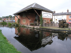
Within a few minutes I had put my rucksack on, and had started walking along the road towards the canal. I entered the little canalside garden where Glyndwr's Way ends, and after smiling at seeing the monument at the end of the trail I joined the towpath and started heading southwards out of the town. Initially the towpath was surfaced as it passed a lock and a large canalside building housing a museum, but after passing a footbridge with a Travis Perkins on the left it became classic canal towpath walking. Opposite the builder's merchants there was a small section of narrow-gauge railway on the towpath, set into concrete, and near to this there was a barge.
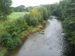
The Shropshire Union Canal is a network of canals in Shropshire, running from Wolverhampton to Ellesmere Port, and Middlewich to Newtown, with branches to Shrewsbury and Llangollen. Not all of the network is navigable, and this includes the stretch that I walked today, the Montgomeryshire Canal, which is only partial navigable.
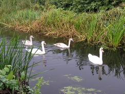
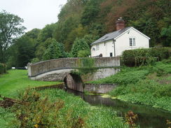
It was an enjoyable stroll southwards, the only downside being the noise from the adjacent A490 road. On the other side of the road was the parkland that surrounds Powis Castle, and on a couple of occasions I got glimpses of a red-brick building (the castle?) itself. The road used to cut the canal off, but it was rebuilt on a new course and a new bridge constructed under the road a few yards ago. The old, truncated, course of the canal had been converted into a wildlife reserve, and as I passed a solitary fisherman he made a comment that it looked as if it was going to rain soon.
As if he had brought down a curse upon us it started to spit with rain as I continued along the towpath, and although it was not too heavy I was glad that I had put my coat on before the walk began. I did not bother putting the hood of my coat up, and instead relied on my Tilley hat to keep my head dry. The route that I was follolwing is also part of the Severn Way, and part of the reason for choosing this route is that I want to complete all of that trail - I have already done a fair few miles further downstream.
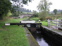
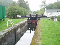
The rain started to get heavier as I headed southwards past Belan Locks; just above these there was a solitary narrowboat, the only one that I saw in the entire day. This navigable stretch of canal is not yet connected to the rest of the waterways network, and this means that narrowboats do not often get to cruise this canal, as they need to be transpoted by road to reach it. Hopefully this will change in the future, but the lack of use meant that parts of the canal were fairly overgrown. The canal passed two locks situated close together, and above one of these was a narrowboat, the only one that I saw during the entire day. A short distance on the rain paused slightly, before restarting about ten minutes later when I passed through a short tunnel, and not stopping until the end of the day.
As I walked on towards Berriew the rain continued to get heavier, although my coat and the Tilley Hat were helping keep me dry. I resisted the temptation to nip into the pub in the village as I knew I still had to drive home once the walk was over, and instead walked towards the aqueduct over the River Rhiw. Just before this there was a minidigger with long boom dredging the canal, dropping the resultant muck on the side of the bank. I ensured that I made eye cntact with the driver before squeezing past, and just by the aqueduct was another man clearing vegetation using a strimmer.
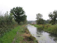
A little further on at Refail the canal was blocked by a road, and this marked the end of the current navigable stretch of the canal. I went through a gate and crossed the road, and although the canal on the other side is still in water it was far more overgrown. Unfortunately this also included the towpath, and as the vegetation was drenched with rain I started getting drenched by squeezing past low-hanging branches. There were a couple of tree branches in the canal, stretching across the entire width and blocking navigation.
After another kilometre there was another blockage, where the course of the canal had been interrupted by the A483 road. This was fairly busy and I carefully crossed this, before walking along the verge opposite the Nag's Head pub. The canal continued on along the other side, heading southwestwards along what was fortunately a clearer towpath, with less vegetation to drench me. I put my Walkman on to give me something to listen to, the sound of the rain being fairly depressing. The rain was lashing down, and although my body under my waterproofs I was dry I was fairly wet on my hands and face.
I was using my Olympus 8080 camera, but the rain was getting heavier and so I decided to change over to use my waterproof camera instead. I took my rucksack off and placed it onto the sodden ground whilst I swapped over, and then put it back on before starting off. After a few yards I realised that the new camera did not have a memory card in it, so I had to go through the rigmarole of taking the pack off once again to dig deep for a card.
The towpath crossed the road on the level once again, and ran parallel to the A483, the noise of the road intruding on what was an easy walk. Near a house the towpath crossed over to the other, western, side of the canal for a few yards as it passed a lock, before crossing over to the other side once past the lock near Bridge 146. A short distance further on the canal headed under the A483(T) via a concrete bridge, whilst the towpath diverted away for a short distance to head under a bridge that carried the road across the floodplain. On the left was the River Severn, and once under the bridge the towpath rejoined the canal to reach a newly-restored lock, the gates stating 2003 on them.
A little further on there was another lock that was unrestored, the top of it being fenced off and the bottom being very overgrown. The path led on as the canal became totally infilled to another disused lock as the rain got heavier, and after this a road was joined past a sewage farm. Past this the path headed through a tree-filled cutting, with a bare rock wall to the right and the River Severn down to the left. In the dry this would be a very pleasant spot, but in the wet weather today it was not particularly nice and I just wanted to get to the end of the walk. Trees were growing out of the old bed of the canal, and I soon arrived at another lock that was hardly visible amongst the vegetation that surrounded it.
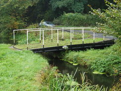
The path joined national cycle route 81, and the path underfoot became a tarmac path. This allowed me to make good time as the path squeezed by what would at on time have been a canalside cottage, and immediately beyond this there was an attractive footbridge that is now rather redundant. As I followed the path southwestwards the scene was getting increasingly urban, and the sound of traffic was getting louder as I approached the outskirts of Newtown. The path suddenly emerged out into an area with a floodbank on the right (running along the old course of the canal) and the river down on the left. Just before a bridge over the river is reached I left the path and joined the bridge.
the views from the bridge down over the Severn were nice, but the views over the town itself were not particularly good, with a McDonalds dominating the view to the right; the only nice things to see were some large red-brick buildings in the distance. I followed roads for a short distance through the town, passing an old department store before reaching the railway station just as it stopped raining. I went into the ticket office and purchased a ticket for the journey back, and as I had twenty minutes to wait for the train I went across the road to the supermarket to buy some snacks for the long drive back to Cambridge.
Unfortunately the rain really meant that this walk was a bit of a wash-out, but I was glad that I did it nonetheless; it is another stretch of the Severn Way completed, and another date on which I have not walked. It was also a nice, easy walk on which to finish this particular trip, the level walking contrasting sharply with the stiff climbs of the previous six days.
Directions
This walk starts off at the old station in Welshpool (which is across a main road from the current railway station). Leave the station and follow a road towards the centre of the town; after about a hundred yards descend down to the canal towpath and start following this southwestwards for about fourteen miles. The canal eventually becomes infilled as it approaches Aberbechan; continue on along the path (which eventually becomes a cycle path) as it enters Newtown. A flood bank appears on the right, with the river Severn down to the left from the path.
Just before a bridge over the river is reached turn right along a path that leads for a few yards to a road opposite some white cottages. Turn left, and follow this road for a few yards initially running alongside the houses before curving to the right alongside the bridge. Once the bridge approach roads has lowered enough turn left to join the bridge, and turn left to cross the river. At a roundabout on the other side continue straight on up Kerry Road, and just before a bridge over the railway is reached turn right down Old Kerry Road. Follow this road as it heads downhill for about a hundred yards, and then turn left past an old department store; the station is on the left opposite a supermarket.
Distances
| From | To | Distance (m) | Ascent (ft) | Descent (ft) |
|---|---|---|---|---|
| Welshpool station | Berriew | 5.3 | 180 | 141 |
| Berriew | A483 in Abermule | 5.1 | 197 | 184 |
| A483 in Abermule | Newtown station | 4.3 | 279 | 184 |
This makes a total distance of 14.7 miles, with 656 feet of ascent and 509 feet of descent.
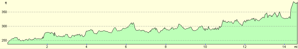
For more information on profiles, ascents and descents, see this page
Transport
There are several train services a day between Newtown and Welshpool. A single ticket costs £3.00, and the journey takes about fifteen minutes.
Disclaimer
Please note that I take no responsibility for anything that may happen when following these directions. If you intend to follow this route, then please use the relevant maps and check the route out before you go out. As always when walking, use common sense and you should be fine.
If you find any information on any of these routes that is inaccurate, or you wish to add anything, then please email me.
All images on this site are © of the author. Any reproduction, retransmissions, or republication of all or part of any document found on this site is expressly prohibited, unless the author has explicitly granted its prior written consent to so reproduce, retransmit, or republish the material. All other rights reserved.
Although this site includes links providing convenient direct access to other Internet sites, I do not endorse, approve, certify or make warranties or representations as to the accuracy of the information on these sites.
And finally, enjoy your walking!
Nearby walks
| # | Title | Walk length (miles) |
|---|---|---|
| 690 | Glyndwr's Way: Beacon Hill to Abbeycwmhir | 22.2 |
| 745 | Glyndwr's Way: Dolanog to Welshpool | 19.7 |
| 764 | Spoad Hill to Buttington Bridge | 21.7 |
|
|

|