Walk #747: Thames Path: Shiplake to Maidenhead
 |
 |
|
General Data
| Date Walked | 29/10/2006 |
| County | Berkshire, Buckinghamshire |
| Start Location | Shiplake Lock |
| End Location | Maidenhead station |
| Start time | 08.20 |
| End time | 15.47 |
| Distance | 20.6 miles |
| Description | This was an enjoyale stroll following the Thames Path as it wound its way eastwards, passing through henley and Marlow on the way. |
| Pack | Today I carried my 30-litre Karrimor rucksack filled with my waterproofs, two litres of water, and various other odds and ends. |
| Condition | My right knee started aching after a couple of miles, and this continued at different intesisities for the rest of the dy. Aside from this I had no problems, and if there had been more time then I could have walked further. |
| Weather | The day was surprisingly warm for the time of year, and ther were even a couple of men walking around topless - this is an unusual sight for later October. There were few clouds in the sky at any time, and there was not much of a breeze either. |
| OS map | Landranger number 175 (Reading & Windsor, Henley-on-Thames & Bracknell) |
 |
 |
|
 |
 |
|
Map of the walk
Maps courtesy of Google Maps. Route for indicative purposes only, and may have been plotted after the walk. Please let me have comments on what you think of this new format. For a detailed table of timings for this walk, please see the table file.
 |
 |
|
 |
 |
|
Notes
It was time for me to do the next stretch of the Thames Path, and so I got up early in the morning to start the long drive down to Shiplake. The drive took me slightly longer than I expected, but I still arrived at the lane near Shiplake Lock in plenty of time, and parked up behind a white van. The verge at the side of the lane was filling up with cars from fishermen, and several were chatting as I hurriedly put my kit together and started the walk, heading down towards the lock.
I was delayed at a clapper gate by the lock due to a fisherman trying to negotiate his gear through it, and after I took a couple of photographs of the lock I headed back to the end of the lane, and started walking along the muddy footpath that headed northwards towards Shiplake. There was no sign of the river, which was across the fields to the right, and the footpath soon ended. After having to negotiate a muddy patch, at another lane.
I started following the lane northwards towards Shiplake, but after a few minutes I realised that I had left my mobile phone on the charger in my car, in plain view. It was obvious that it would be unwise to leave it there (and anyway I would need to use it later in the day), so I reluctantly started back along the lane towards the car, sticking to the slightly shorter road route than the footpath across the fields back to the lock. When I got to the car I found that I had left one of the Ordnance Survey maps behind as well as the phone, so I picked that up and started off back down the lane, annoyed at the twenty minute delay in the start of the walk.
Once I reached Shiplake I nipped into a newsagents to buy a bottle of Ribena and a chocolate bar, and started off down the road past the station. A narrow path between houses followed, after which the path joined a road that passed some large and probably quite expensive houses. At the end of the road a path led on back towards the river, and to my right I was surprised to see what was quite an extensive garden railway, with pointwork and even a large miniature station in the garden. I would love to know more information about this, as it looked superbly maintained, and I was left wondering what rolling stock ran along the line.
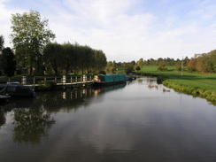
When I reached the river bank a cruiser came past, letting me know that I was finally back at the river. The path followed the edge of fields before reaching a lock, where the towpath went across a bridge to reach the lockside, with some good views back down the river. The lock was well maintained and pretty, like all the Thames Locks that I have passed so far, and another bridge led back to the riverbank for the walk towards Henley.
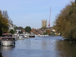
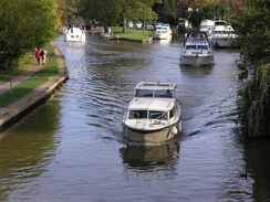
On the way I passed a series of fishermen, and then a rowing museum on the grass to the left. When I reached Henley Bridge I got my first memories of when I had walked along this stretch in early 2000, in the form of a cast-iron sign on the bridge giving old details of the weights allowed on the bridge. Once on the other side of the bridge I followed the towpath northwards, past a series of rowing boats getting ready to go on the river. Indeed, the riverside was packed with boats, with many cars, minibusses and boat trailers parked on the grass, and it was obvious that some sort of race was going to be going on later in the day.
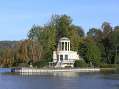
As I walked along with a firm path underfoot a number of rowers came jogging past, obviously warming up their muscles ready for the exhertions of the day ahead. At one point I passed a small white tent erected by the towpath, covering a PA system; it was obviously not going to be a small event. As I headed north along the canal the chaos eased slightly, and after getting some momentary views of Fawley Court on the other side of the river, soon reached the amazing fishing lodge on Temple Island in the middle of the river, the cupola on top sheltering a naked lady looking up the river. I remembered this well from my first walk along this stretch of the path, and the small structure looked just as good as I recalled.
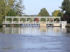
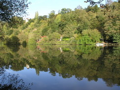
A fairly pleasant stretch of path followed as the river curved to take qa more easterly and then southeasterly course to reach Hambleden Lock, with the mill clad with white weatherboard visible on the far side of the river. A short distance beyond the lock the path left the riverside and headed up a lane into the hamlet of Aston, passing a pub that looked inviting to visit, if only it had not been so early. Instead I followed the path as it headed up a hill and then skirted past the 18th Century Culham Court, which unfortunately was not very visible behind the hedges and unnecessarily restrictive double fences.
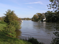
The path descended down to meet the river once again, and there were plenty of people about, walking along the river with their children and dogs. I could not blame them as it was a very pleasant stretch of river, and I let all of my senses revel in the riverside scene as I headed east towards Hurley Lock, and then onto the Temple Bridge, which is a graceful arch over the river, built to replace a ferry that closed after the Second World War. As I started across the bridge a grey squirrel ran along the handrail past me before jumping onto the branch of a tree, and I watched mesmerised as it jumped from branch to branch through the trees. Occasionally I get moments like this on a walk where I feel very close to nature, and they often occur in the most unexpected places.
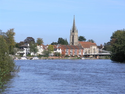
As the path followed the river downstream towards Marlow I enjoyed some views across to the pretty Bisham Church, and before I knew it the towpath had reached Marlow Bridge, the suspension bridge spanning the river elegantly. Here the path left the river for a period, and I got slightly off the route as I headed through the town, having been distracted by a beautiful if slightly worn statue of a naked lady sitting on top of a water fountain. It was not far off route, and I had soon reached the river again by the Two Brewers pub, and I decided to stop off here for a drink. The pub was fairly packed, so I ordered my usual summertime order consisting of a pint of bitter, a pint of orange and lemonade and a packet of crisps, and went to sit on a bench outside the pub. The sun was shining and I enjoyed the stay outside the pub as I slowly drunk the pints, glad to have the weight off my feet for a while.
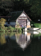
Eventually I could not delay any longer, and I shouldered my rucksack and headed off down a footpath that ran between walls from beside the pub, and then followed a road before eventually heading out onto fields beside the river. Initially this stretch was dominated by the large viaduct carrying the A404 road over the river, but this was soon left behind as the river curved to head northeastwards, with pretty boathouses and houses nestling on the other side of the river. It was another pleasant stretch of river, with plenty to see as I strolled along towards Bourne End.
As I entered the little town I passed a series of boat houses, before reaching the rail bridge that led over the river. This is where the path also crosses over the river, using a footbridge attached to the side of the rail bridge, and as I crossed a train rumbled across past me. Once on the other side of the bridge I descended down steps to rejoin the towpath, which headed roughly southwards before curving to the east towards Cookham.
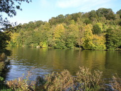
Before the bridge over the river in the village was reached the path left the riverside and headed down towards and past the pretty church. Cookham had some pleasant buildings, and I enjoyed the walk through to the weird Tarry Stone, a sarsen stone highly visible and well maintained by the pavement. The next stretch down the main road was less pleasant, but the road was soon left behind as the path headed eastwards down another road that led towards the river. The path soon left the road and headed through a shaded glade down towards the river, and when I finally reached it I was greeted with a superb view across the river towards the estate cottages and boathouses of the Cliveden Estate, made infamous during the Profumo affair in the sixties.
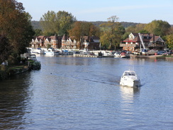
The next stretch of path was a joy as it followed the river southwards, and there were some glorious views across to the wooded hillside on the other side of the river. In places the path was slightly narrow, and as the hedge on the right overhung it there was a very rural feel. This soon had to end, and it did so as houses started to encroach on the right, and then as it met a main road. Fortunately there was a pavement, and this made it easy to head south past Bolulter Lock, which was pretty with a hotel on the island in the middle of the river. On the pavement near the lock there was a stone plaque inlaid into pavement: "Old father Thames goes gliding by: As ripples run he winks his eye. At Cotswold cows & Oxford dons; nodding to Windsor's royal swans, he bears our nation's liquid crown, by lock and weir to London town. May all that know and love his bank, pause here awhile to offer thanks.", a lovely poe, by Ian Miles.
It was not far from here to reach Maidenhead Bridge, and on the way I passed a couple of small boats pulling in warning signs situated on boats in the middle of the river - there had been a regatta during the day, and the signs had been to warn motor cruisers and narrow boats about the rowing boats. At the bridge I turned away from the river and started the mile-long walk to Maidenhead station, a walk that started off not particularly pretty, and descended as it went on. One of the few things to note was an office building housing a branch of ARM PLC, a company that I have some interest in as I once worked for Acorn, the company that developed the ARM processor.
When I got to the station I quickly purchased a ticket and went up to wait for the train that would take me back towards Shiplake. I did not have too long to wait for the first train, but there was a wait at the next station for the branch line towards Shiplake and Henley. I was tired by this time, and my legs had stiffened by the time that I finally reached Shiplake station, and it took a couple of hundred yards for them to loosen up. Consequently the stroll back to my car from the station was not particularly pleasant, and it was with relief when I finally reached it and prepared for the long drive back to Cambridge.
 |
Directions
| The walk is also covered in detail in the Thames Path National Trail Guide, by David Sharp, ISBN 1-84513-062-6 published by Aurum Press Ltd. Click on the image to the right to go to the Amazon page for the book. For the directions from Maidenhead Bridge to the station in Maidenhead, also look at the directions given in the book. | 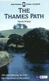 |
Distances
| From | To | Distance (m) | Ascent (ft) | Descent (ft) |
|---|---|---|---|---|
| Shiplake Lock | Henley | 3.1 | 59 | 62 |
| Henley | Marlow | 8.9 | 236 | 246 |
| Marlow | Cookham | 4.3 | 66 | 72 |
| Cookham | Maidenhead station | 4.3 | 49 | 36 |
This makes a total distance of 20.6 miles, with 410 feet of ascent and 416 feet of descent.
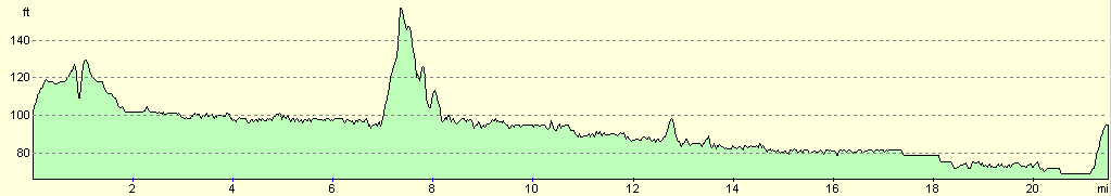
For more information on profiles, ascents and descents, see this page
Transport
There are regular train services from Maidenhead to Shiplake, although you have to change trains at Twyford station. A single ticket for the trip cost me £3.70.
Disclaimer
Please note that I take no responsibility for anything that may happen when following these directions. If you intend to follow this route, then please use the relevant maps and check the route out before you go out. As always when walking, use common sense and you should be fine.
If you find any information on any of these routes that is inaccurate, or you wish to add anything, then please email me.
All images on this site are © of the author. Any reproduction, retransmissions, or republication of all or part of any document found on this site is expressly prohibited, unless the author has explicitly granted its prior written consent to so reproduce, retransmit, or republish the material. All other rights reserved.
Although this site includes links providing convenient direct access to other Internet sites, I do not endorse, approve, certify or make warranties or representations as to the accuracy of the information on these sites.
And finally, enjoy your walking!
Nearby walks
| # | Title | Walk length (miles) |
|---|---|---|
| 60 | Slough to Alperton | 16.7 |
| 61 | Reading to Marlow | 18.5 |
| 62 | Marlow to Slough | 16.3 |
|
|

|