Walk #395: Aberath to Aberystwyth
 |
 |
|
General Data
| Date Walked | 26/03/2003 |
| County | Dyfed |
| Start Location | Aberath |
| End Location | Aberystwyth |
| Start time | 10.02 |
| End time | 16.53 |
| Distance | 16.1 miles |
| Description | This was an annoying walk, as in many places footpaths that existed on the Ordnance Survey map, and in other places there were footpaths where none existed on the maps. |
| Pack | Today I carried my 30-litre Karrimor HotRock rucksack, which was filled with my packed lunch, waterproof leggings, water bottle and a couple of spare shirts, together with the usual assortment of odds and ends. |
| Condition | Aside from a little hotspot on my left foot, I feel fine after this walk. I have a slight amount of rashing on my back, and this proved slightly annoying, but not enough to worry me overly. |
| Weather | The weather today was absolutely superb - it was quite hot, and there as hardly a cloud in the sky all day. There was also a cool breeze that was nice when I was hot on the climbs. All in all it was a lovely day. |
| OS map | Landranger number 146 (Lampeter, Llandovery & surrounding area) and Landranger number 135 (Aberystwyth & Machynlleth) |
 |
 |
|
 |
Map of the walk
Maps courtesy of Google Maps. Route for indicative purposes only, and may have been plotted after the walk. Please let me have comments on what you think of this new format. For a detailed table of timings for this walk, please see the table file.
Notes
There was a very late start to today's walk, and this meant that I was rushing today to get the walk completed. The late start was probably worth it, however as it allowed me to get a website update done, ready to b sent to Terry for uploading to the server. I have not done an update for three weeks, so the time spent doing it was worth it. Writing up the photographs seems to take up the majority of my time, and I should really try and find a quicker way of doing this, or even perhaps I should start taking less photographs!
I met a man on the beach in Aberath who was rifling through his rucksack. It turned out that he was on a walk from Borth to Cardigan, part of a longer sectional Sheffield to Newport walk. I chatted to him abut the route ahead, and he said that the path marked on the map did not exist on the ground, and progress was hard. He had climbed over two barbed wire fences, and one of these had gashed his leg in two places. I was therefore faced with three choices; I could either attempt to walk along the beach; I could make my way across the fields and make my own path; or I could walk along the A487(T) road. The first option was too risky, as I was unsure about whether I could walk along the shingle beach all the way, and as the cliff were high I would have had no escape route if the tide had come in. The option of walking along the main road was also quite unappealing, as it was quite busy. I therefore decided to walk across the fields, although I chose to do a high-level route so that I could divert onto the road if I needed to. The path was hard, but I only had one fence to climb over before I reached a new section of path. At one stage I passed right by a newborn lamb that was by a stile, and its mother responded by rather ineffectually tapping its foot at me.
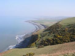
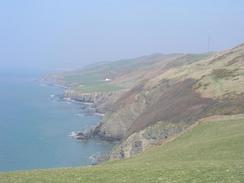
The last section of walk into Aberystwyth was quite spectacular, and in a few places it felt like a real ridge walk. At the start of the descent down into the town there is a large abandoned quarry, and I spent a couple of minutes looking around it, a massive gouge out of the hillside. I wish that the local councils could create a proper coastal path to Aberystwyth, as the cliffs are crying out for one. It is particularly bad that footpaths that are marked on the maps and which have been eroded away have not been replaced; this is confusing and forces people to either trespass or walk along the main road.
Sam organised for me to have a radio interview with Ceredigion Radio the radio station for the area. It is a Welsh-speaking station, and so I had visions of being asked questions in Welsh. Fortunately the interview was in English, and although I had some trouble saying the Welsh place names it seemed to go quite well, and I enjoyed doing it.
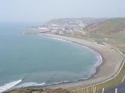
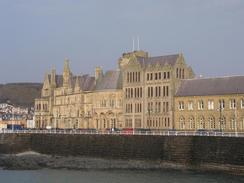
Aberystwyth is quite a nice little town, and I enjoyed my enforced walk around it. The ruins of the castle are quite nice, although not much was left after it was mined after the civil war. We stopped for a quick drink in the Inn on the Pier, and although this pub was quite well situated and nice inside I did not like it very much as the interior was smoky and the seat in the toilet was exceedingly unhygienic, to say the least.
Tomorrow I have a long walk to try and get as far as Machynlleth, and unfortunately this means that I shall have to do a great deal of road walking. For this reason I may well change into my trainers after Upper Borth, to save strain on my feet (walking for many miles on tarmac on my boots is not the most comfortable experience).
Directions
This walk starts off at a road on the south side of the stream in Aberath. Head through the small village past the church and cross the stream on the pedestrian footbridge. From here you have a choice; you can either walk northeastwards along the A487 road or you can walk across the fields between the cliff edge and the road. Note that the footpath marked on the map does not exist on the ground, and therefore it is a case of going cross-country. Try to keep quite high on the hillside and away from the cliff edge; the going here appeared to be easier.
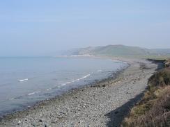
Eventually a new path (not marked on the OS map) is reached. This path winds its way around the hillside before descending near Morfa Mawr farm and heading around the coast to a road to the south of Llan-non. Cross the stream using the bridge that leads into the caravan park, There is a footpath marked on the map leading north into Llansantffraed from here; this path had been eroded away, so join the shingle beach and walk along this past the village, before turning to the right to head towards the church.
Cross the stream by the church and head past it along a green lane that carries a footpath. The green lane soon ends, and a footpath continues on before it rejoins the edge of the cliff. The path passes four or five limekilns before it ends at a track. Join the shingle beach here, and follow it northwards until a car park is met behind the bank, from which a road leads eastwards towards the A487 road in Llanrhystud. When the A487 road is reached turn left along it for a few hundred yards, until a footpath leads off to the left, crossing a bridge over a stream before ending at a road beside a church. Turn right along this road and pass the church until it meets the A487 road once again.
Turn left along it for a few yards and then take the first road off to the left, which leads uphill to a series of houses. Before one of these is reached a footpath leads off to the right, heading up through some woodland before emerging at a track beside a small farm. Head past the farm building and then, when the footpath turns to the left to head northwestwards, cut north cross-country (there is no right of way here) for about half a mile to meet a footpath that runs along the top of the hills beside the cliffs. Follow this footpath as it contours along the hills before reaching the whitewashed farm at Pantyrallad.
From Pantyrallad I cut cross-country northwards to the abandoned farm at Ffos-las; there is no right of way here and the track marked on the map is essentially nonexistent on the ground, but the going was good and I reached the ruins of the farm quite quickly. From Ffos-las a bridleway heads northeastwards uphill to meet a track above Cwm-ceirw. Follow the track around, and when it meets a surfaced road turn left to head downhill along the road. Just before the caravan site at Morfa Bychn is reached turn right along a footpath that heads northwards, climbing uphill along a little ridge before eventually steeply descending to meet a track on a little plain.
Follow this track northwards until it meets a bridge over a river by the mouth of the harbour. Turn right and follow the road around until it meets the A487 road, and then turn left to follow it over The Rheidol River using the Trefechan Bridge, before turning left along South Road that leads to the promenade beside the sea. Turn right to walk past along the promenade to Castle Point, and then continue along the promenade to the Royal Pier, where this walk ends.
Distances
| From | To | Distance (m) | Ascent (ft) | Descent (ft) |
|---|---|---|---|---|
| Aberath | Llanrhystud | 6.3 | 604 | 594 |
| Llanrhystud | Aberystwyth | 9.8 | 1903 | 1949 |
This makes a total distance of 16.1 miles, with 2507 feet of ascent and 2543 feet of descent.
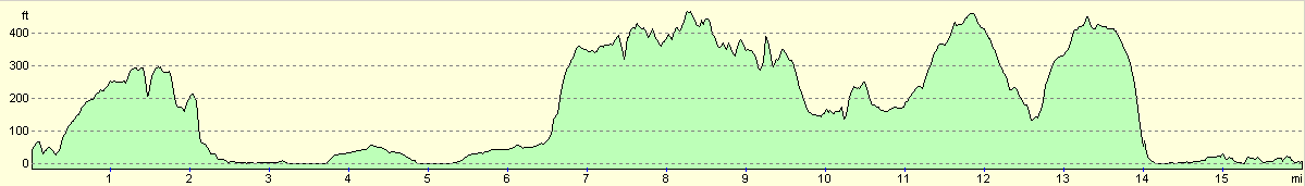
For more information on profiles, ascents and descents, see this page
Accommodation
Sam had parked Mervan in the long-stay park and ride car park in Aberystwyth, which was a short walk (or a free bus ride) from the town centre. There were few facilities about, but we did not really need any, and we could easily have walked into town if we had wanted to.
Disclaimer
Please note that I take no responsibility for anything that may happen when following these directions. If you intend to follow this route, then please use the relevant maps and check the route out before you go out. As always when walking, use common sense and you should be fine.
If you find any information on any of these routes that is inaccurate, or you wish to add anything, then please email me.
All images on this site are © of the author. Any reproduction, retransmissions, or republication of all or part of any document found on this site is expressly prohibited, unless the author has explicitly granted its prior written consent to so reproduce, retransmit, or republish the material. All other rights reserved.
Although this site includes links providing convenient direct access to other Internet sites, I do not endorse, approve, certify or make warranties or representations as to the accuracy of the information on these sites.
And finally, enjoy your walking!
This walk was mentioned in the following routes:
| My walk around the coastline of Britain |
Nearby walks
| # | Title | Walk length (miles) |
|---|---|---|
| 394 | Llangranog to Aberath | 16.9 |
|
|

|