Walk #396: Aberystwyth to Cwrt
 |
 |
|
General Data
| Date Walked | 27/03/2003 |
| County | Dyfed, Gwynedd |
| Start Location | Aberystwyth |
| End Location | Cwrt |
| Start time | 08.47 |
| End time | 16.54 |
| Distance | 19.9 miles |
| Description | This was a long walk of two halves; a nice walk along cliffs and Borth Sands was followed by a long, boring and sometimes dangerous walk along the B4353 and A487(T) road. |
| Pack | Today I carried my 30-litre Karrimor HotRock rucksack, which was filled with my packed lunch, waterproof leggings, water bottle and a couple of spare shirts, together with the usual assortment of odds and ends. |
| Condition | I feel more or les okay after this walk, although this evening I have had quite a severe stomach ache that sent me to bed early. |
| Weather | Today was another warm and sunny day with scarcely a cloud in the sky. There was quite a significant breeze in exposed places, although this was not enough to annoy or worry me, and indeed it helped keep me cool. |
| OS map | Landranger number 135 (Aberystwyth & Machynlleth) |
 |
 |
|
 |
Map of the walk
Maps courtesy of Google Maps. Route for indicative purposes only, and may have been plotted after the walk. Please let me have comments on what you think of this new format. For a detailed table of timings for this walk, please see the table file.
Notes
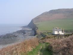
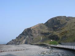
The first part of the walk north out of Aberystwyth over Constitution Hill was quite nice, and the views over the town from the top was quite nice, despite the haze in the air (you are supposed to be able to see Snowdonia easily on a clear day, but I there was no chance of that today). At the top I met a man from Buxton who was delivering a new radar system to the coastguard station at the top of the hill. I chatted to him and his colleague for a while about the walk and the height of cliffs that I have seen. The descent from Constitution Hill down into Clarach Bay was quite nice, but it was followed by a series of steep ascents and descents along the cliff top footpath past Wallog before reaching the war memorial above Upper Borth, from where the view north along the beach was marvellous.
I met Sam by the lifeboat station in Borth, and I used the opportunity to use the nearby public toilets. I had heard a rumour overnight that the company that I used to work for, Pace, was going to make the rest of their engineers in the Cambridge office redundant. Sam phone up a friend of ours and unfortunately the rumour is true - all of the remaining engineers are going to be made redundant, and only the sales and marketing people are going to retain their jobs as the engineering work will be outsourced. This is a terrible shame, as they are a great team of engineers, and they will now be dissipated. As the remainder of the walk was going to be along beaches or roads, I also used the opportunity to change out of my boots and into my trainers, which are more comfortable on roads.
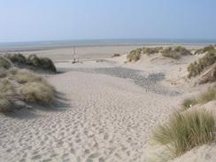
The next stretch of walk up to Twyi Bach was quite nice - I walked the first stretch along he road and seawall through Borth (which is a very narrow and long village), and when the seawall ended I continued along the beautiful beach beside the sand dunes. This was a most enjoyable little walk, and I strode along it quite fast, seeing the hills behind Aberdovey on the other side of the estuary grow bigger as I walked towards them.
The walk along the B4353 was not too bad; the road was generally straight, wide and quiet, so I never really felt endangered on it. Unfortunately the next road, the A487(T), was a vastly different matter. I joined the road in the village of Tre'r-ddol, where the pub, which is marked on the map, shut at Christmas. From here the road was quite busy, winding and in places narrow, a combination that made the walk quite nasty. The only good thing was the village of Furnace, where there are the remains of a large furnace and an absolutely lovely waterfall immediately to the south. I frequently had to stop and press myself into the hedge to allow lorries past safely, and this made me thoroughly depressed, particularly as I realised that I had a long distance still to go before I could reach Machynlleth, where I was due to meet Sam.
At Glandyfi the road became even narrower, and I started to hate the walk even more. It was then that I decided to investigate another idea. In the book about his pioneering walk in 1977, John Merrill describes how he crossed the river using the rail bridge from Dovey Junction Station. I had decided against doing this as it is not a right of way, but after due consideration I thought that a careful crossing of the bridge would be safer than walking along the A487 - it is also a much shorter route. I therefore walked along the track that leads to the station (it is the only railway station in the United Kingdom that has no road access). A train from Aberystwyth passed me just before I reached the station, and after it had pulled off I walked beside the track to the end of the bridge. After carefully looking in both directions and listening for any trains, I started to run across. The path beside the single track was narrow, and there were many things that I could have tripped over, but I made it safely to the other side.
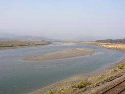
On the other side of the bridge there is a little house (apparently the owner has the right to walk across the bridge), and beside this I dropped down onto the floodplain beside the river. From here a footpath took me northwestwards to the farm at Ynys. On the way I managed to get a little reception on my mobile phone, and I rang Sam to tell her that I had changed my plans and that I would meet her at the curiously named Cwrt. From Ynys a road leads off northwards to meet the A493 in Cwrt, but amazingly I managed to miss this and I ended up walking along a track that headed northeastwards. By the time that I realised that I had gone wrong I decided the best thing to do would be to cut cross-country to the west, and I soon found the road one again, whilst kicking myself for making such a stupid mistake.
Tomorrow I have another road walk along the A493 to do to get to Aberdovey. It looks as though this road will be quieter than the A487 on the southern side, but even so I am not looking forward to walking along it. I may set off early in the morning to avoid the traffic, or if the worst comes to the worst I may follow roads and tracks that parallel the estuary on the hillside to the north. Unfortunately the weather forecast is for there to be some rain tomorrow (the first for a fortnight, so I cannot complain too much), and the forecasters cannot say whether it will be in the morning or afternoon, or how long it shall last.
Directions
This walk starts at the Royal Pier by the seafront in Aberystwyth. From the pier head north through the town, heading for the base of the cliff railway. To the left of the base station a broad footpath heads off uphill, crossing the railway twice before it eventually reaches the top of the hill, where another footpath heads downhill to meet a road at Clarach Bay. Follow the road north to a little footbridge over a stream, from where another footpath heads uphill. This footpath follows the cliff edge up and down a series of hills, passing Wallog before eventually descending near a caravan park before ascending one final time to a war memorial above Upper Borth. At the memorial the path turns to the right to descend down to the road in Upper Borth.
Follow the road through Upper Borth, and when it meets the B4353 road turn left and walk northwards past the lifeboat station through Borth, or alternatively you can choose to walk along the beach. When the seawall ended I continued on northwards along the beach until just before the dunes on the right end. Here a wooden causeway across the dunes leads to a car park beside the visitors centre for the Dyfi National Nature Reserve. From the car park turn right to head southwards for a kilometre along a public road, before turning to the left to walk eastwards down a bridleway (there are no right of way signs, though), before it ends at the B4353 road near the bridge over the Afon Leri.
Follow the B4353 road for a couple of miles eastwards until the junction with the A487(T) road is reached in Tre'r-ddol. Turn left and very carefully follow the A487(T) northeastwards - there is no pavement and the road was quite busy, so you may want to pick another route through the hills to the east. The road passes through the little village of Furnace before reaching a narrow section of road in Glandyfi. Here you have a choice; you can either continue along the road to Machynlleth and out along the A493 along the northern bank of the river to Cwrt, or you could do the shorter (but illegal) route that I describe below.
Walk through Glandyfi until you reach the entrance to Dovey Junction Station. Follow the track along beside the railway line northwards for a kilometre to the railway station. From the station carefully follow the railway line (walk beside it and not between the rails) the short distance to the bridge. When you reach the bridge look and listen for any oncoming trains (they can come from either direction) before crossing the bridge. On the other side next to the house turn right and descend down onto the floodplain. From here a footpath heads off northwestwards to meet a road at the farm at Ynys; the footpath was indistinct on the ground but I found it easy to make my own way across the floodplain, but if there has been a flood recently this could be very hard. At the farm follow the road northwards for a couple of kilometres until it ends at the A493 road in Cwrt, where this walk ends.
Distances
| From | To | Distance (m) | Ascent (ft) | Descent (ft) |
|---|---|---|---|---|
| Aberystwyth | Borth | 5.2 | 1263 | 1260 |
| Borth | Twyni Bach | 3.8 | 23 | 26 |
| Twyni Bach | Cwrt | 10.9 | 659 | 597 |
This makes a total distance of 19.9 miles, with 1945 feet of ascent and 1883 feet of descent.
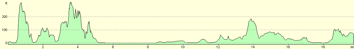
For more information on profiles, ascents and descents, see this page
Accommodation
There is a handy car park beside the A493 in Cwrt where the road from Ynys meets it, but we decided to drive the mile eastwards into Pennal, where the owners of the Riverside Inn kindly allowed us to stay in their car park.
Disclaimer
Please note that I take no responsibility for anything that may happen when following these directions. If you intend to follow this route, then please use the relevant maps and check the route out before you go out. As always when walking, use common sense and you should be fine.
If you find any information on any of these routes that is inaccurate, or you wish to add anything, then please email me.
All images on this site are © of the author. Any reproduction, retransmissions, or republication of all or part of any document found on this site is expressly prohibited, unless the author has explicitly granted its prior written consent to so reproduce, retransmit, or republish the material. All other rights reserved.
Although this site includes links providing convenient direct access to other Internet sites, I do not endorse, approve, certify or make warranties or representations as to the accuracy of the information on these sites.
And finally, enjoy your walking!
This walk was mentioned in the following routes:
| My walk around the coastline of Britain |
Nearby walks
| # | Title | Walk length (miles) |
|---|---|---|
| 395 | Aberath to Aberystwyth | 16.1 |
| 397 | Cwrt to Fairbourne | 22.3 |
| 741 | Glyndwr's Way: Llwynygog to Forge | 18.9 |
|
|

|