Walk #654: Leicester to Loughborough
 |
 |
|
General Data
| Date Walked | 12/03/2005 |
| County | Leicestershire |
| Start Location | Leicester Railway Station |
| End Location | Loughborough station |
| Start time | 09.09 |
| End time | 15.31 |
| Distance | 19.0 miles |
| Description | This was a surprisingly beautiful walk, and one with some unexpectedly lovely patches of moorland. |
| Pack | Today I carried my 30-litre Karrimor rucksack, filled with my usual set of detritus, including waterproofs, water and my electrical gear. |
| Condition | I feel fine after this walk; the only minor problem that I have is a couple of hot-spots on my right foot. I am also slightly fatigued, but as much as anything that is probably due to the early start this morning and long drive. |
| Weather | The day started off sunny but with a bitterly cold northerly wind. The frost on ground soon disappeared and when I was out of the wind I felt quite warm, but when exposed to it I felt very cold all day. As the day progressed the skies started to cloud over, but fortunately it never threatened to rain. |
| OS map | Landranger number 140 (Leicester, Coventry & Rugby) and Landranger number 129 (Nottingham & Loughborough, Melton Mowbray) |
 |
 |
|
 |
 |
|
Map of the walk
Maps courtesy of Google Maps. Route for indicative purposes only, and may have been plotted after the walk. Please let me have comments on what you think of this new format. For a detailed table of timings for this walk, please see the table file.
 |
 |
|
 |
Notes
For a few years I have been wanting to complete a walk from Leicester to Loughborough, but a number of reasons have precluded me from doing this walk. One of the main reasons is the fact that by taking the obvious route following the River Soar the walk would only be eleven or twelve miles long, not really long enough considering the length of drive needed to get to Leicester. Today, however, I decided to bite the bullet and do the walk. To fix the distance problem I studied the Ordnance Survey map and decided that, instead of following the River Soar, I would take a more indirect route that wound over the hills of Charnwood Forest.
I therefore found myself driving along the A14 and A6 early in the morning to get to Leicester; when I reached the town I drove past the railway station (where I had ended two previous walks) to find a car park. This did not prove too difficult, and I soon pulled up into the Dover Street car park. A day's ticket cost me £3.70, and whilst it is cheaper on Sundays during the week it is far more expensive. It did not take me long to get my kit on, and I was soon striding the short distance through the town to the railway station. Here I checked the train times back from Loughborough (which was hardly necessary as there are many every hour) and went outside to start the walk.
Instantly the bitterly cold wind, which was to be one of the main features of the day, made itself felt. Even though I was surrounded by buildings the wind still seemed to cut me through to the core, and it was obvious that the cloudless skies overhead had let the temperatures plummet overnight. I walked past the statue of Thomas Cook (founder of the travel firm of the same name, and the originator of package holidays) and under a subway, to make a slight diversion back to the car park as I had forgotten my mobile phone. Leicester was quite quiet as I walked through, with only early morning shoppers out and about, and many shops not yet opened for the day, and I enjoyed my stroll through the city centre. On the route that I took there were not many buildings of obvious architectural interest, and I soon found myself at a rather depressingly ugly bus station.
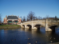
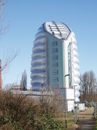
I crossed one tributary of the River Soar by the A6 bridge, and after crossing the main river I started walking along its northern bank through Abbey Park. A slight diversion took me into the park where there were some scant, although interesting, remains of the abbey (mainly the curtain wall dividing the abbey from the river) and some attractive flower beds. A short distance further on I passed the National Space Centre; a peculiar yet strangely fascinating building that soars into the sky like a rocket. Standing close by the base and looking up the plastic-clad exterior is uplifting, and that is something that I rarely say about modern architecture.
Soon after this I left the river and headed across the A6 towards the A653 road. A quiet road then took me northwards out of Mowmacre Hill, climbing up and becoming progressively quieter as it climbed. Near the top there is a trig pillar marked on the map, but when I did a quick search for it I could not find it, and a long linear pile of rubble marked its approximate location. It could still be present as I gave a somewhat abbreviated search, but it was certainly not obvious. This failure disheartened me slightly, and I headed on up the road as it headed to the west of Birstall towards the village of Thurcaston. On the way I crossed the A46(T) on a bridge, and in the distance I could see steam rising from a train heading towards Rothley Station on the Great Central Railway, a preserved railway line.
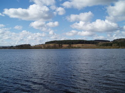
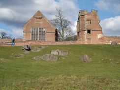
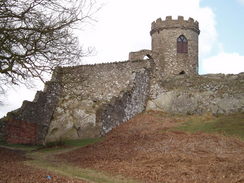
Thurcaston Church made for a pleasant sight, and as I headed westwards along the footpath towards the next village of Cropston I crossed a lovely little double-arch bridge over Rothley Brook, a sight that was unfortunately marred by the high-tension power cables that were nearly overhead. I resisted the temptation to nip into the pub in Cropston and instead walked along the road that formed the dam of Cropston Reservoir, which was a superb sight in the bright sunshine. The water glistened as I looked down its length, and it started to dawn on me that a walk that I had expected to be fairly uninteresting may have a few surprises up its sleeve. I reached the car park at the northern end of the reservoir and started walking along a track that ran down the western side; this was busy with many people walking down it and was well surfaced, which surprised me slightly as I had not expected it to be this popular. The reason behind the popularity became clear when the path left the side of the reservoir and headed westwards, because I soon reached the majestic brick ruins of Bradgate Hall. These were totally unexpected and the setting, with moorland behind, could easily have been in the moorland of Derbyshire. The public could not access the main ruins, but children were climbing the small rocky outcrops adjacent to them, and people really seemed to be enjoying themselves.
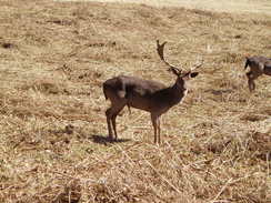
I did not stop to explore further, as my eyes were being drawn uphill to another gem, the Old John Tower and nearby monument, both of which were visible on the skyline to the northwest. When I planned the walk I had intended to follow the Leicestershire Round path that skirts downhill from the tower, but the sight of the moorland and the tower persuaded me to head uphill to explore them. It was obvious that many other people had done this as there were plenty of tracks criss-crossing the land, and I followed a relatively minor one that led directly uphill towards the monument. On the way I passed some superb rocky outcrops that I just wanted to scramble over, before reaching the memorial. This turned out to be dedicated to all the people in Leicestershire who died in the First World War, and I stopped to study it for a few minutes. Getting a decent photograph proved to be difficult due to the angle of the sun, and as the wind was bitterly cold I soon turned round and started walking around the edge of some woodland towards Old John Tower. On the way came a highlight of the day; as I walked I approached some deer - not the usual Muntjac type that I see occasionally in Cambridgeshire, but larger deer with large antlers. They heard me approach and looked up, but I was surprised to see that they did not run away. I got my camera out and cautiously approached, taking photographs as I got closer. They were obviously used to people and allowed me to get very close - much closer than proper wild deer would - and it was truly a magical moment as I took many photographs of them.
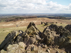
Eventually they ran away (although not very far) to the other side of the path, and I climbed up the short distance to the Old John Tower. This is a folly, but the views were superb, and I stood by the viewpoint looking down over Leicestershire for a few minutes. I was feeling literally and metaphorically high as I looked out, and I could reflect on the fact that this walk was turning out to be something special. On the descent down from the tower I passed yet more rocky outcrops before reaching the car park and rejoining the Leicestershire Round, which headed across a seemingly never-ending golf course before approaching the village of Woodhouse Eaves. Here the path took a very indirect route as it looped up over Broombriggs Hill, from where I could see the next target of the day, Beacon Hill, before descending down to meet a road. A path led into the Beacon Hill Country Park, and I was soon confidently striding up a well-surfaced path towards the top of the hill. The park was fairly busy with people, which is hardly a surprise as just before I reached the summit I passed a large car park. The summit used to be the site of an old hill fort and some earthworks were still just about discernable as the path rose.
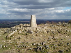
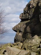
The trig pillar was easy to find, and was situated amongst an area of rocky outcrops. The area was fairly busy, and someone was flying a kite in the brisk winds. It was, frankly, a lovely area, and after photographing he trig pillar and some views I started to explore a little. The rocky outcrops were just calling out to be scrambled over, and I gleefully did so as I descended back down to the path. Here I came across the next surprise; one rocky outcrop gave a very good outline of a human face, with mouth, eyebrow ridge and nose all prominent. I noticed this before I read the information board about it, which shows precisely how prominent it is. The path slowly descended through woodland eastwards before reaching a car park, where I avoided the road for a while by following a bridleway through the park. This dumped me unceremoniously onto the road, which thankfully I only had to follow for a short distance before diverting off down a track that led towards a farm. After this a bridleway led me on northwards across fields and into the outskirts of Loughborough.
The walk through Loughborough was a slight let-down after the superb walk that I had done, and there was not much of interest as I headed through the town. Road took me northeastwards into the town centre, and I avoided the very centre by heading towards the bus station and then on towards the railway station. This is dominated by the presence of the Bush engineering works on the other side of the railway line, vast, grey industrial buildings that still produce vast electrical and mechanical machines, although no longer to they produce railway locomotives. I purchased my ticket and only had to wait for a few minutes before my train back to Leicester arrived, and I sat down looking back on what had been a surprisingly brilliant days walking.
Directions
This walk starts off al Leicester railway station. Leave the station and turn right, to walk past the statue of Thomas Cook and on to a subway. Enter the subway and go under the road to gain access to Granby Street. Follow this road northwestwards and continue on as it becomes pedestrianised, eventually passing a tower and heading up Church Gate before ending at the A594 road at the A6 junction opposite a church. Carefully cross the A594 and start following the A6 dual carriageway northwestwards; it crosses one tributary of the River Soar before reaching the main river. Cross the bridge and then turn right, to start following a path along the western bank of the River Soar as it heads westwards past Abbey Park.
The path passes under Abbey Park Road and continues on northwards; it soon passes the futuristic building that houses the National Space Centre and heads on northwards. When a road bridge is reached near SK590073 leave the river and turn left to walk westwards along Thurcaston Road for a short distance until it reaches the A6. Carefully cross the A6, and once on the other side head northwestwards along Thurcaston lane until it ends at the A563 road after a few hundred yards. Turn et along the A563 for a few yards until a roundabout is reached, and then turn right along a road that climbs northwestwards up Mowmacre Hill. When the road reached the top it levels off and heads in a more northerly direction, passing a large industrial estate. The road is eventually blocked too traffic, but it is easy to walk past the barrier and onto Leicester Road.
Head northwards along Leicester Road, and follow it as it crosses the A46(T), after which it curves to a more northwesterly direction as it descends down into Thurcaston. Once In the village take the first road off to the left, Rectory Lane, and follow it as it heads westwards and ends at a T-junction with Anstey Lane. Turn left along this lane for a few yards until Thurcaston Church is reached. Immediately beyond the church a footpath leads off to the right; this squeezes pat the church yard before heading westwards towards a nice stone bridge over Rothley Brook. Continue on as the footpath heads westwards across fields before ending at Waterfield Road in Cropston. Turn left along this road for a few yards until it ends at Cropston Road, and then turn right to follow Cropston Road north into Cropston. At a complex junction near the Badger's Sett pub, continue straight on along Reservoir Road.
This descends to Cropston reservoir dam and follows it northwestwards before curving to the left to head westwards. When a car park is reached turn left to enter it, and then continue on along a broad, surfaced track that joins the western bank of the reservoir as it heads south towards a visitors centre. Here it curves to the right to slowly curve away from the reservoir, eventually settling on a westerly course until the prominent ruins of Bradgate Hall are reached. Walk past the ruins and then immediately turn right, to started heading northwestwards across some moorland. Head directly for the monument on the skyline (Old John Tower should be to the right of the monument); there are many paths on the ground, and although the path becomes steeper immediately before the monument it is a fairly easy and uncomplicated walk.
Once the monument is reached turn right and walk along the southeastern edge of some woodland to reach Old John Tower. Leave the tower by following a path that heads north, descending down some crags before reaching a car park. Here the :Leicestershire Round path is reached, which is well way marked and will be followed for the next few miles. Leave the car park and start walking northwards along a road straight ahead; after a few hundred yards turn right and follow the Leicestershire Round as it heads northwestwards across a golf course. It soon reaches and crosses another road, before continuing across the golf course to the east of Mapplewall Hall School and ending at a road immediately to the south of the village of Woodhouse Eaves.
Turn right to head downhill northwards along the road for a few yards, until the Leicestershire Round leads off to the let along a well-surfaced path. It continues along the path for a short distance before heading off to the left, climbing uphill to the west and skirting the southern edge of some woodland. It is well way marked as it curves around over Broombriggs Hill, eventually curving to the right to head downhill eastwards and ending at a road. Cross the road and take a short path that leads to a surfaced track in Beacon Hill country park. Turn left and start following the track as it heads westwards uphill, initially skirting the road. As the summit approaches a car park is reached, and soon the trig pillar at the top becomes visible. The path curves around at the top and starts to head eastwards downhill for over a kilometre before ending at a car park at the eastern edge of the park.
Here you can leave the car park and turn left to head northwestwards along the road, however there is traffic free route that goes through the park on the other side of the hedge form the road. Eventually the traffic free path ends and you have to join the road for a couple of hundred yards. When a road comes in from the left turn right down a track that leads eastwards; when a junction is reached turn left along a track that leads towards a house. The track ends at the house but the footpath continues on, squeezing to the right of the house and continuing on northwards before curving slightly to the east. The path is easy to follow and eventually it becomes an unsurfaced track before it ends at a road junction in the southern outskirts of Loughborough.
At the junction head straight on along Beacon Road, which heads northeastwards uphill towards a roundabout with the A6004 Epinal Way. Continue straight across the roundabout and continue on along Beacon road as it heads northwards towards the centre of Loughborough. When a junction is reached turn left along another road for a few yards and then turn right to head northeastwards along the B5350 road for a short distance until it curves to the right; here continue straight on along a pedestrianised road that soon reaches the A512 road. Cross the road and on the other side follow Baxter Gate and a series of small roads through the centre of the town, heading northeastwards until the A60 is reached. Head northeastwards along the A60 until just before it climbs up over a railway line; here turn left and walk up the station approach to Loughborough railways station, where this walk ends.
Distances
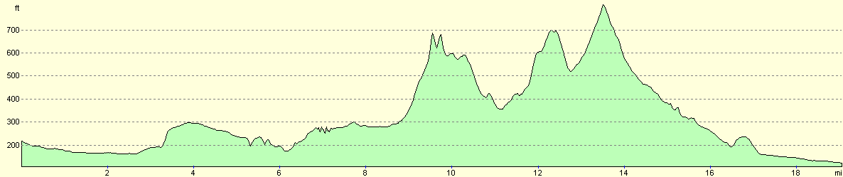
| From | To | Distance (m) | Ascent (ft) | Descent (ft) |
|---|---|---|---|---|
| Leicester railway station | Thurcaston Church | 5.8 | 213 | 226 |
| Thurcaston Church | Old John Tower | 3.8 | 692 | 253 |
| Old John Tower | Beacon Hill | 3.9 | 725 | 568 |
| Beacon Hill | Loughborough railway station | 5.5 | 62 | 745 |
This makes a total distance of 19.0 miles, with 1692 feet of ascent and 1792 feet of descent.
For more information on profiles, ascents and descents, see this page
Transport
There are regular train services between Loughborough and Leicester railway stations. A single ticket costs £3.30, and the journey takes about a quarter of an hour for a non-stopping service.
Disclaimer
Please note that I take no responsibility for anything that may happen when following these directions. If you intend to follow this route, then please use the relevant maps and check the route out before you go out. As always when walking, use common sense and you should be fine.
If you find any information on any of these routes that is inaccurate, or you wish to add anything, then please email me.
All images on this site are © of the author. Any reproduction, retransmissions, or republication of all or part of any document found on this site is expressly prohibited, unless the author has explicitly granted its prior written consent to so reproduce, retransmit, or republish the material. All other rights reserved.
Although this site includes links providing convenient direct access to other Internet sites, I do not endorse, approve, certify or make warranties or representations as to the accuracy of the information on these sites.
And finally, enjoy your walking!
Nearby walks
| # | Title | Walk length (miles) |
|---|---|---|
| 138 | Market Harborough to Leicester | 17.7 |
| 205 | Oakham to Leicester | 19.5 |
| 662 | A circular walk to Bardon Hill | 19.8 |
|
|

|