Walk #205: Oakham to Leicester
 |
 |
|
 |
 |
|
General Data
| Date Walked | 30/06/2002 |
| County | Rutland, Leicestershire |
| Start Location | Oakham |
| End Location | Leicester Railway Station |
| Start time | 07.55 |
| End time | 15.10 |
| Distance | 19.5 miles |
| Description | This was a lovely walk, taking in the highest point in the county of Rutland. It involves a mixture of road and footpath walking over some nice terrain. |
| Pack | I carried my 30-litre rucksack, with Psion 5, coat, maps and spare batteries. |
| Condition | I feel fine after this walk, and after a little rest I could easily have walked further. The main problem is a blister on the third toe on my right foot, in a position where I cannot recall ever having had a blister before. This could be due to the fact that I walked the entire way in my trainers. I also have a cut on the middle finger of my left hand, where I tried to over-enthusiastically climb over a hawthorn bush that was in the path. My back gave a little twinge at one stage in the middle of the walk, but this only lasted for a few minutes before it subsided once more. |
| Weather | The weather today was overcast, but it never threatened to rain at any time and there was little sight of any sun. There was a fairly keen wind, which meant that in exposed places I needed my fleece on to keep warm, but in sheltered places on climbs I was overheating rapidly and had to unzip it to try and stabilise my temperature. All in all it was a nice day for walking. |
| OS map | Landranger number 140 (Leicester, Coventry & Rugby) and Landranger number 141 (Kettering, Corby & surrounding area) |
 |
Map of the walk
Maps courtesy of Google Maps. Route for indicative purposes only, and may have been plotted after the walk. Please let me have comments on what you think of this new format. For a detailed table of timings for this walk, please see the table file.
Notes
This was a highly enjoyable walk, which allowed me to reach the highest point in the county of Rutland. I was expecting this to be about a twenty-mile walk, so I set off from Cambridge at 6.45 so that I could reach Oakham and start the walk fairly early. It was also fairly unusual in that I had not planned an exact route westwards once I reached Cold Overton Park, as I had decided to choose the route I would take once I had actually started.
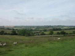
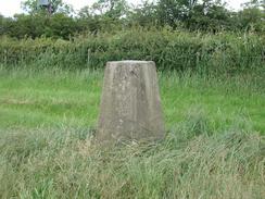
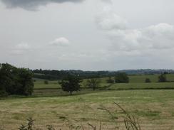
The views over Rutland Water from near Cold Overton Park were lovely, with the reservoir being well set off against the rolling hills behind it. The county top is marked by a Trig Point which is at the top of a rather flat-topped hill, with the view to the north being dominated by a transmission mast. It was nice to reach yet another county top, although there are still many that I have to reach. The previous day Sam, myself and two friends had done a 25-mile bike ride around Rutland Water, so it was with some interest that I looked at it from afar.
To the southeast of Owston the path crosses an old railway line. I normally find these of great interest, but the climb up to the top of the steep embankment was quite difficult as the ground was just soil with nettles overgrowing it. I found the climb quite difficult as my feet kept on slipping and I was trying to avoid falling into the nettles. When I reached the top of the embankment I could see the semblance of a track running along it, although I did not have any inclination to see how far it went. A little over a mile and a half to the northeast of where the footpath crosses the railway line is a triangular junction at John O'Gaunt, which may be worth exploring sometime in the future. Fortunately the descent down the other, southern, side of the embankment was easier and less steep, although it was followed by another climb through a field.
At the top of the hill leading towards Tilton on the Hill from the old railway line, the path passes through a farmyard. Around this farmyard were lots of little signs, and being of a curious nature I decided to look at them. it turned out that these signs are for a farm trail that is run by Halstead House Farm, and I enjoyed looking around the buildings as I walked past, including a pig in a sty. The farm also contained a little shop, and I visited this to buy a carton of Ribena and some homemade jam. The man running the shop was a friendly soul, and we had a nice chat. The farm trail costs three pounds to visit, and it looks as though it could be god value for families with young children. It is nice to see such diversification in the countryside, although it is sad that farmers cannot make money from farming itself nowadays.
By the time I reached Keyham I was feeling a bit tired and in need of a rest, so I decided to drop down a lane into the village so that I could visit the pub marked on the map for a drink and a rest. The pub I found was called The Dog and Gun, and I had a very nice pint of Tiger Bitter there whilst I waited. It was not long before my feet felt wanderlust once more, and I set off, trying to avoid listening to the world cup final in my walkman headphones. Unfortunately I succumbed, and even though I am not a football fan I listened to the second half as I started the descent down into the city centre.
The last three miles of the walk down into Leicester was a fairly boring plod along roads, with not much to see. I normally enliven such a walk by looking at the architecture of the buildings, but unfortunately there was not much to see on either side of the roads that I was walking along. Indeed the area looked depressed, which was a sad end to the day. The exception was the Midland Station in Leicester which, although the stonework was in need of a good clean, was a magnificent example of Victorian engineering. The buildings had little crests and plaques scattered around it which I stopped to read. I just wish the same care and attention could be given to modern buildings, but in these days of cost-consciousness it unfortunately does not pay.
There are a multitude of choices about which walk I can do next. There are the two walks from Leciester northwards to Long Eaton, the walk from Northamton to Towcester, or the walk from Rushden to Northampton, all of which will complete circular walks.
Directions
This walk starts off from the railway station car park in Oakham, the main town in the county of Rutland. Leave the station and head for the point where the A606 and B668 Station road meet, immediately to the south of the station. This is a fairly complex junction, with a railway crossing and four roads meeting. At the junction take Cold Overton Road, which heads westwards out of the town.
Cold Overton road slowly rises as it heads westwards, with a transmission mast becoming larger on the skyline as it is approached. When the mast is finally reached a road junction to the right becomes visible, and opposite this junction a track comes in from the left, skirting past the supports of the mast. Take the bridleway that follows this lane as it heads southwards. After a short distance the lane ends and the bridleway continues south southwestwards to the left of a hedge. Shortly after the bridleway crosses into another field take a footpath that leads off to the right and heads westwards towards the southern edge of Cold Overton Park Wood.
Halfway to the woodland some horse jumps are visible in the hedge to the right. If you look through these the Trig point that marks the highest point in the County of Rutland can be seen across the field. This can make a nice detour, although as there is no footpath to the trig point you would technically be trespassing.
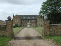
Once you have visited the trig point return to the footpath and continue on westwards along the footpath. The path skirts the southern edge of the woodland before emerging at Lady Wood Lodge farm. Continue straight on through the grounds of the farm and then descend across a field to cross a stream. The path then rises as it heads westwards for about a kilometre until it arrives at the large and attractive Bleak House, on the eastern side of Knossington. Join the driveway of the house and follow it for a short distance until a road is met.
Once the road is met turn left and follow the road as it descends downhill to a road junction. At the junction continue straight on to head westwards through Knossington. Take the second road to the left, just before the phone box is reached. This road descends downhill to the south-southwest before turning westwards to head towards Owston. Shortly beyond a crossroads at SK 7922 0811 a footpath leads off to the left to cross fields into the village of Owston. This path was very overgrown and unkempt when I walked in, and it is not much longer to continue along the road into the village, so the choice is yours.
The footpath emerges at a road on the eastern side of Owston. Turn left down the road for a few yards and then take a road that leads off to the right, to head north-westwards. After a few hundred yards take a road that leads to the left for a short distance until it ends at a T-junction. At this junction turn right for a few yards to a footpath that leads off to the left.
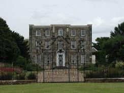
Follow this footpath as it descends and rises as it heads south-westwards for a kilometre until it meets the immaculate driveway of Owston Lodge. Cross the driveway and continue south-westwards, crossing a track leading to Stone Lodge Farm before descending down to meet the embankment of an old railway line. Carefully ascend the steep bank and continue on down the other side to a field. The path climbs up this field, still on a south-westerly heading, until it meets Halstead House Farm.
Continue thought the grounds of the farm until a surfaced track is reached. Continue for a few hundred yards along this track until it ends at a road. Turn right along this road and follow it for a little under a kilometre until it reaches the church in Tilton on the Hill.
Follow the road for a short distance past the church until it ends at a junction with the B6047 road. Turn left along the B6047 and follow it for about 900 metres until a road junction is reached on the left, just after the road passes under some power lines. Turn right and follow this road as it heads north-south-westwards for a little over two and a half kilometres to reach two areas of woodland, Botany Box Fox Covert on the right and Bilesdon Coplow on the left. Just before these areas of woodland a road leads off to the right, heading south-north-westwards for over four kilometres to the village of Keyham.
Continue on the road north-westwards out of Keyham. After a few hundred metres the road swings sharply around to the left and descends steeply down to Scraptoft Lodge Farm. It then climbs up the other side of the valley before ending at a T-junction with Beeby Road.
Turn left and follow Beeby Road as it heads southwards past a golf course and enters Scraptoft. Follow the road as it turns sharply to the right beside an entrance to a college, and follow it for a short distance westwards until a road junction to the left is reached. Turn left and follow Church Hill road southwards until it ends at a T-junction beside the church in Scraptoft.
At the junction turn right to head westwards along Scraptoft Lane for about two and a half kilometres until it ends at a junction with the A47(T) Ambassador Road. Continue straight on along the A47(T) as it becomes Uppingham Road and heads westwards into the city centre. It then becomes Humberstone Road and passes under three railway bridges side-by-side. Shortly after this it becomes a dual carriageway for a short distance until a roundabout with the A594 is reached. Turn left and follow the A594 St Georges Way as it curves around southwards for a little under a kilometre. Leicester Railway Station is directly opposite the junction of the A594 and A6(T) roads.
Distances
| From | To | Distance (m) | Ascent (ft) | Descent (ft) |
|---|---|---|---|---|
| Oakham Station | Tilton on the Hill | 8.5 | 951 | 617 |
| Tilton on the Hill | Keyham | 5.0 | 184 | 479 |
| Keyham | Leicester Railway Station | 6.0 | 217 | 390 |
This makes a total distance of 19.5 miles, with 1352 feet of ascent and 1486 feet of descent.
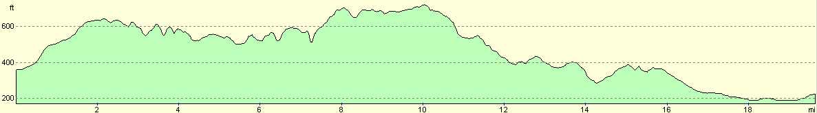
For more information on profiles, ascents and descents, see this page
Transport
There are regular train services running from Leicester to Oakham, calling at Melton Mowbray on the way. There are also some bus and coach services between the two towns.
Disclaimer
Please note that I take no responsibility for anything that may happen when following these directions. If you intend to follow this route, then please use the relevant maps and check the route out before you go out. As always when walking, use common sense and you should be fine.
If you find any information on any of these routes that is inaccurate, or you wish to add anything, then please email me.
All images on this site are © of the author. Any reproduction, retransmissions, or republication of all or part of any document found on this site is expressly prohibited, unless the author has explicitly granted its prior written consent to so reproduce, retransmit, or republish the material. All other rights reserved.
Although this site includes links providing convenient direct access to other Internet sites, I do not endorse, approve, certify or make warranties or representations as to the accuracy of the information on these sites.
And finally, enjoy your walking!
Nearby walks
| # | Title | Walk length (miles) |
|---|---|---|
| 58 | Stamford to Oakham | 16.8 |
| 59 | Oakham to Melton Mowbray | 10.6 |
| 138 | Market Harborough to Leicester | 17.7 |
|
|

|