Walk #204: Tring to Princes Risborough
 |
 |
|
 |
 |
|
General Data
| Date Walked | 23/06/2002 |
| County | Hertfordshire, Buckinghamshire |
| Start Location | Tring |
| End Location | Princes Risborough Station |
| Start time | 10.00 |
| End time | 15.30 |
| Distance | 13.5 miles |
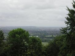
| Description | This was a lovely walk, taking in the county tops of Buckinghamshire and Hertfordshire. The route followed the Ridgeway National Trail, and some of the views were fairly spectacular. |
| Pack | I carried my 30-litre Karrimor Hotrock rucksack, filled with fleece, Coat, Psion 5, and other little pieces of equipment. |
| Condition | I found this walk to be a little harder than it should have been; this was probably due to the fact that I had not done a walk for about a month. I am generally okay when I finished, but the underside of my right knee was aching slightly, which made me not want to continue any further. |
| Weather | The weather today was fairly nice, with a temperature of about 20 degrees and a slight wind to help keep me cool. There was a layer of cloud, which meant that the sun did not really make an appearance at all during the day, which meant that getting sunburnt was not a problem. |
| OS map | Landranger number 165 (Aylesbury & Leighton Buzzard, Thame & Berkhamstead) |
 |
 |
|
Map of the walk
Maps courtesy of Google Maps. Route for indicative purposes only, and may have been plotted after the walk. Please let me have comments on what you think of this new format. For a detailed table of timings for this walk, please see the table file.
Notes
The main aim of this walk was to be able to get to the highest points of Buckinghamshire and Hertfordshire, and hence be able to tick off these tops on my County Tops list. The two tops are fairly close to each other on the Chiltern Hills, so it was easy to do them in one go.
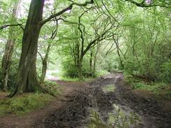
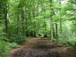
This was really an excellent walk, and probably one of the best that I have done in England for some time. The paths were muddy in places, and the chalk underfoot could have been slippy if it had been wetter. The route I chose follows the Ridgeway National Trail for the majority of the way, and this dived in and out of some lovely wooded land.
The first top that I reached was the county top of Hertfordshire, which is on the edge of Pavis Wood on the boundary between Hertfordshire and Buckinghamshire. As with many county tops that are on a border between two counties it was very hard to see any noticeable top, but I made sure that I was at the position indicated by the GPS, which happened to be more or less on the Ridgeway. Unfortunately a cairn of discarded household goods marked the top, including what looked like an old fridge, which was a great shame. The track through Pavis Wood itself was very nice, although a little muddy in places, and I let my mind wander as my feet went on automatic pilot.
When I got to the top of Haddington Hill, where I expected to find the county top of Buckinghamshire, I was greeted with a paved road and an ice cream van, a coach and many parked cars. I used my GPS to guide me to the location that I believed to be the highest point of the county, but when I got there it looked wrong as it was obviously slightly downhill from the summit. I then asked a local, who told me that there was a stone cairn that marked the spot, and I the spent over half an hour wandering around the woodland trying to find it. I eventually found it at the end of a sidetrack, and it was marked as being the highest point of the entire Chiltern Hills. It was some distance from what I believed to be the top, so either the list I used is inaccurate or I copied it incorrectly off the website. Finding it made the search thoroughly worthwhile, and indeed it was a highpoint of the day.
I stopped for lunch at The White Swan pub in Wendover, where I had a pint of Moorland Original and a pack of crisps which was followed by a pint of orange and lemonade. This was quite a nice little pub, with a flag stone floor and an aesthetically pleasing bar.
At the top of Coombe Hill I was very surprised to find a tall monument dominating what was a very imposing viewpoint. The monument commemorated the Boer War, and there were two plaques on it - one of which had a list of names on it and the other which gave details of the lightning strike that nearly completely destroyed the monument on the thirties. There was a sad note, however; the stone plaque with the names on also stated that the plaque replaced a bronze one that had been stolen - a terrible thing. In front of the monument was a trig point in a concrete box - a quite unusual trig point and not what I was expecting.
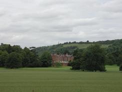
The Ridgeway passes through the grounds of Chequers, which is the prime ministers country estate. I entered the estate through an open gate that was beside a slightly overgrown stile, to be greeted by a large, black, and ominous-looking pole, on top of which were two cameras pointing directly at me. As I walked past it I noticed that it turned to follow me, so I did a backwards-and-forwards movement to see if it would track me, which it did.
At this point a car pulled up on the road beside me and two middle-aged ladies got out. I was still studying the camera when they came through the gate, and we started chatting as we crossed the field, across an obvious path through the crops. As we were walking one of them asked me: "Are you a member of the security services?". "No", I replied, "But even if I was then I would say no, wouldn't I?". She thought about this and said, "Yes, that is true."
As we continued across the field towards the main driveway (which is behind a haha so you cannot see the house from the driveway where the path crosses) I was asked "What do you do for a living?", to which I replied, "A senior software engineer in Cambridge." She pondered this for a moment and said, "Good cover!".
It was at this point that my mind blew. This lady honestly thought that I was a member of the security services wandering around the grounds of Chequers. True, I had a digital camera, GPS and folded map case around my neck, but that could just as easily mark me out as being a hiker (I was on a National Trail) as being a spook.
My mind then bent further. Perhaps these ladies were actually security agents, checking out this stubbly-faced figure that had been staring intently at the cameras! Perhaps they had been called out to investigate me!
What followed was a five-minute chat, where both sides were obviously asking questions to try and work out if the other was lying. Of course, I know that I am not a spook, but I was wondering how (and if) I could convince them of this. They even got to the stage of asking me exactly where in Cambridge I lived, which they seemed not to believe.
After the incident in Cornwall in April 2000 where I was suspected of being a member of special branch, I am starting to wonder if there is something about me that makes people think that I am in some way shady. Perhaps it is the stubble ;-)
This walk now sets me up to walk from Princes Risborough down to Marlow, and hence create a small circular route taking in small sections of the Thames Path, the Grand Union Canal and the Ridgeway National Trail.
Directions
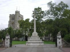
This walk starts off at a car park beside a church in Tring. This is adjacent to the bus station, but about two miles away from the railway station, which is to the east of the town.
Leave the car park and turn right to head westwards past the church along the B4635 High Street. After a short distance turn left to head south along Akeman Street. When this road ends at a T-junction with Park Street by the Zoological Museum, turn right along Park Street and then immediately left, to head south along Hastoe Lane.
Hastoe Lane passes under the A41(T) and then starts to climb uphill. Shortly after the bridge under the A41(T) the road veers to the right to head southwestwards up Hastoe Hill. When a junction on the left is met, continue straight on.
The road ends at a T-junction in Hastoe. Turn right along Gadmore Lane and follow it for a short distance until it bends sharply to the left, to head southwards. This bend marks the highest point of the county of Hertfordshire, on the boundary of Pavis Wood. Instead of following the road at the bend, enter Pavis Wood by a gate and follow a wide and muddy track that leads southwestwards through the wood.
After about a kilometre the track emerges at another road. On the other side of the road a track leads off westwards through a small area of woodland, immediately to the north of some houses. After about half a mile this road ends at another road.
Turn left and head up this road for a short distance until you meet a footpath that heads off to the right. Take this footpath as it heads north-westwards across fields before entering a wooded area. This path is indistinct on the ground with many paths heading out in various directions, but if you follow the correct one then it eventually meets a surfaced track (which looks better than many of the roads in the area) in Wendover Woods.
Follow this track as it heads westwards for a short distance to a large clearing that contains a building and parking areas. Shortly before the clearing is reached a path leading off to the right from the track leads to the highest point of the county of Buckinghamshire, which is marked by a cairn and plaque. This was actually fairly hard to find as it is deep within the woodland and cannot be seen from the main track.
Once the car park is reached continue onwards along an unsurfaced track. This track soon curves to the left to head south-westwards and starts to descend towards Boddington Hill. After a junction in the tracks a series of athletic tests (log lifts, sit-up benches, etcetera) are reached. Here a path diverts away to the right and descends steeply down the side of the hill. Near the bottom of the hill the path meets another track. Cross over this and continue descending for a short distance until another track is reached.
Turn left and head westwards along this track as it continues to descend. The track ends at a T-junction with Barlow Road, on the eastern outskirts of Wendover. Continue straight on along Barlow Road and after a short distance turn right down Colet Road to meet the B4009 road. Turn left and follow the B4009 southwestwards into the town centre.
When the B4009 turns sharply to the right in the town centre turn left to continue southwestwards along High Street. This becomes Pound Street as it continues to climb, eventually reaching a bridge over the A413 and the railway line (the railway station is immediately to the right from this bridge).
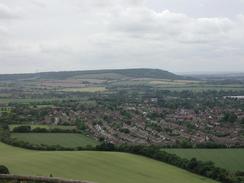
Continue over the bridge and follow Ellesborough Road for a short distance until a bend to the right is reached. At this point a series of footpaths lead off to the left. Follow the one waymarked as the Ridgeway as it heads up Bacombe Hill and eventually onto Coombe Hill, which has a large memorial on the top of it and offers commanding views to the west and north.
From the memorial turn left to head south, following the Ridgeway. After a mile it turns to the right to head westwards to meet another road at the bottom of a hill. Cross the road and take a footpath that heads westwards across fields. A large and ominous pole guards the entrance to the field with cameras mounted on it, the first sign that you have entered the Chequers estate. The path crosses the main driveway leading to Chequers (again guarded by cameras) and heads westwards to meet the edge of an area of woodland.
The path turns right to skirt the eastern and then northern edges of the woodland. At the end of the woodland the path heads westwards before turning southwestwards past Pulpit Hill to meet a road in Lower Cadsden. Turn left along the road for a short distance until the Ridgeway turns to the right, past a pub. From here follow the Ridgeway, which is well signposted, as it winds its way around the hill above the hamlet of Whiteleaf. When it emerges at a road continue along a wide bridleway which heads for a little over a kilometre southwards and then southwestwards until it meets New Road.
Cross over this road and head south-westwards for a kilometre along an unsurfaced track called Upper Icknield Way. When this track ends at the A4010 turn right and follow it towards the centre of the town. After a short distance a road leads off to the left as the B4010 starts to curve to the right. Take this road and follow it for a short distance until it ends at a T-junction with the B4444 Station Road. Turn left and follow Station Road as it curves around to the right. Ignore the first road to the left (Picts Lane), but take the second one, which heads westwards. Princes Risborough Station is a short distance down this road on the left-hand side.
Distances
| From | To | Distance (m) | Ascent (ft) | Descent (ft) |
|---|---|---|---|---|
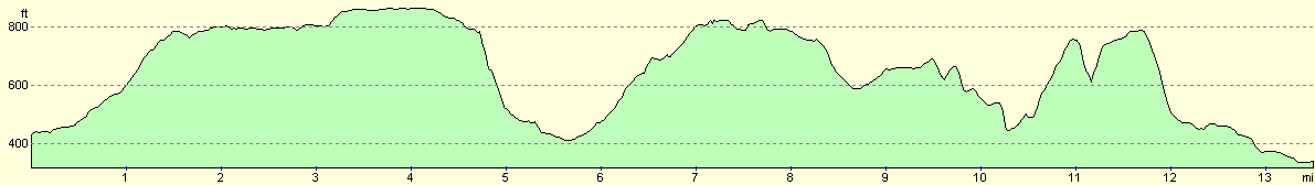
| Tring | Wendover | 5.7 | 525 | 541 |
| Wendover | Princes Risborough | 7.8 | 1224 | 1299 |
This makes a total distance of 13.5 miles, with 1749 feet of ascent and 1840 feet of descent.
For more information on profiles, ascents and descents, see this page
Transport
Sam gave me a lift back from Princes Risborough, so I did not need to take any public transport. There are railway stations at both Tring and Princes Risborough (Tring Station being over a mile west of the town), with trains running from them to London, so if you were attempting to travel between them you would need to change in London.
Disclaimer
Please note that I take no responsibility for anything that may happen when following these directions. If you intend to follow this route, then please use the relevant maps and check the route out before you go out. As always when walking, use common sense and you should be fine.
If you find any information on any of these routes that is inaccurate, or you wish to add anything, then please email me.
All images on this site are © of the author. Any reproduction, retransmissions, or republication of all or part of any document found on this site is expressly prohibited, unless the author has explicitly granted its prior written consent to so reproduce, retransmit, or republish the material. All other rights reserved.
Although this site includes links providing convenient direct access to other Internet sites, I do not endorse, approve, certify or make warranties or representations as to the accuracy of the information on these sites.
And finally, enjoy your walking!
Nearby walks
| # | Title | Walk length (miles) |
|---|---|---|
| 129 | Dunstable to Tring | 14.1 |
| 130 | Tring Station to Hemel Hempstead Station | 8.0 |
| 141 | Tring Station to Cheddington Station | 6.1 |
|
|

|