Walk #130: Tring Station to Hemel Hempstead Station
 |
 |
|
General Data
| Date Walked | 23/12/2000 |
| County | Hertfordshire |
| Start Location | Tring Station |
| End Location | Hemel Hempstead Station |
| Start time | 09.13 |
| End time | 13.34 |
| Distance | 8.0 miles |
| Description | This was a pleasant canal side walk following the Grand Union Canal south through Hertfordshire. |
| Pack | Today I carried my Craghoppers 70-litre rucksack with no tent. |
| Condition | This was a fairly short walk, so I did not suffer at all. I would have continued on south to the next station, but Sam was suffering badly with her feet (she was wearing only one pair of socks), so we stopped early. |
| Weather | The weather today was quite nice, although cold. There was a small amount of low cloud and there was no sign of there being any rain. |
| OS map | Landranger number 165 (Aylesbury & Leighton Buzzard, Thame & Berkhamstead) and Landranger number 166 (Luton & Hertford, Hitchin & St Albans) |
 |
Map of the walk
Maps courtesy of Google Maps. Route for indicative purposes only, and may have been plotted after the walk. Please let me have comments on what you think of this new format. For a detailed table of timings for this walk, please see the table file.
Notes
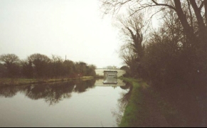
This was a fairly nice walk through some attractive scenery following the Grand Union Canal south from Tring. Canal walking tends to be quite flat and quick progress can be made, however they can tend to wind around the landscape rather than taking the straightest or most direct route. They also tend to be green corridors, and so far I have not found an uninteresting stretch of canal to walk along. Even the Regent's Canal through the centre of London was interesting, and formed what is in my opinion by far the best way to cross London from west to east.
The going was fairly good and not too muddy, which was a slight relief after the last few weeks. In one place the towpath was blocked by works to replace a footbridge, but fortunately the works were advanced enough for us to cross the new bridge. The section from Tring to Berkhamsted was undergoing dredging, and there was a large field to the north of Berkhamsted where the dredged mud was being put. Due to the recent rain this entire area looked as though it was a quagmire, and indeed when viewing the area on the train journey back to Tring there was a sizable lake formed in the middle of the area.
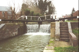
Apparently the Aylesbury Arm of the Grand Union Canal is closed at the moment to boats, due to very high water levels. Since the maps show that the Aylesbury Arm has locks that head downhill, I can only assume that the water level in the Grand Union Canal near Tring reservoirs (where the Aylesbury arm branches off the main canal) is very high. Indeed on the main canal there were several locks where water was cascading over the top of the lock gates, although the water level seemed to be well down from the top of the banks downstream.
We had an early stop after about half an hour when we reached Cowroast Lock, as Sam needed to go to the toilet. Unfortunately the nearby pub was not yet open, and she also tried a petrol station down the road. This was open, but the cashier told us that the toilet was unusable as it had not been cleaned that morning. This meant that Sam had to wait until we reached the pub in Berkhamsted before she was able to relieve herself. There are some advantages in being male, after all ;-)
We both got to Berkhamsted with no problems, but on the outskirts of Hemel Hempstead Sam started complaining of having very sore feet. By the time we got near the station she was starting to hobble slightly, so we decided to end the walk there rather than to continue on to the next station.
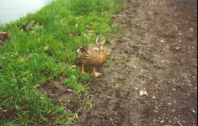
There was a fair amount of wildlife to be seen on this walk, consisting mainly of animals you normally find beside watercourses such as geese, ducks and swans. In one place there was a particularly friendly duck who came up close to me and kindly allowed his photograph to be taken.
I am now in a good position to be able to get down to West Drayton with another two day's walking (ending and starting at Rickmansworth), which means that this section of the walk will be connected up with my Land's End to John O'Groats walk. I shall also be able to extend the walk north up towards Milton Keynes and Northampton, an west along the Ridgeway to Wendover and beyond. As such Tring is going to become one of the major crossing points on my walks.
We had lunch at a pub in Berkhamsted called The Crown. The meal was quite nice (it was part of a pub chain), but the ambiance was nice, despite my choice of sitting in the smoker's area (it was an area that had a wooden floor, meaning that our boots would not get any carpet dirty).
A sign on the pub wall had some interesting information about the signs that hang outside pubs. Hundreds of years ago every business type would have some sign or token denoting what the business was as the vast majority of the population were illiterate. Examples of these were the barber's red and white striped pole, and a sign with sheafs of wheat on for pubs. When towns started having more than one pub, they started having different signs on them to enable people to differentiate between them. There became such a proliferation of signs in most towns that the majority were banned, leaving only the pub signs. I had often wondered where they originated from, and it was nice to discover the answer.
Directions
This walk starts at Tring railway station, where there are many services to the north and south along the West Coast Main Line. Turn left out of the railway station car park and cross the railway by the road bridge. Follow the road westwards until it meets the Grand Union Canal at an over bridge (Tring Station bridge No.135).
Go down the steps to the right and at the bottom turn left, passing under the road bridge. From here it is simply a case of following the canal for about eight miles as it winds it's way to the southeast, passing through Berkhamsted and the very outskirts of Hemel Hempstead.
We diverted from the canal in Berkhamsted so that we could visit a pub to get a meal. This involved us leaving the canal by a supermarket and walking south to the High Street. When you reach the High Street turn left and follow it to the southeast. When you reach the junction with the A416 road to the right turn left down Lower Kings Road and join the canal again at Berkhamsted Station Bridge just south of Berkhamsted Top Lock (No. 53).
Follow the canal for another four miles and take the Station Road Bridge (bridge No. 150), which is immediately south of Fishery Lock No. 63 on the outskirts of Hemel Hempstead. Turn right onto the road and Hemel Hempstead Railway Station is immediately ahead and offset slightly to the left. A gate through a park leads to the station forecourt from the bridge avoiding walking along the road.
Further information
|
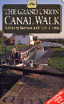
The walk is also covered in detail in the Grand Union Canal Walk, by Anthony Burton and Neil Curtis, ISBN 1 85410 244 3, published by Aurum Press Ltd. Click on the image to the right to go the Amazon page for this book.
For more details on the Grand Union Canal see Jim Shead's canal pages. |
|
Distances
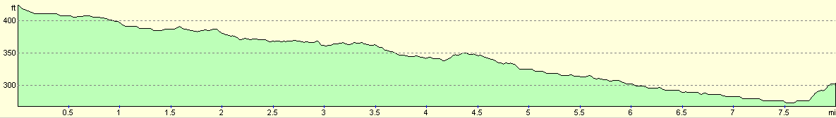
| From | To | Distance (m) | Ascent (ft) | Descent (ft) |
|---|---|---|---|---|
| Tring Station | Berkhamsted | 4.3 | 48 | 135 |
| Berkhamsted | Hemel Hempstead Station | 3.7 | 59 | 102 |
This makes a total distance of 8.0 miles, with 107 feet of ascent and 237 feet of descent.
For more information on profiles, ascents and descents, see this page
Transport
Since this walk follows the West Coast Main Line between two stations, it is simply a case of joining a train for the journey back. On this Saturday there were trains every half hour. This walk was done in the middle of the rail crisis with a special timetable operating, so trains may be more regular in normal service.
Disclaimer
Please note that I take no responsibility for anything that may happen when following these directions. If you intend to follow this route, then please use the relevant maps and check the route out before you go out. As always when walking, use common sense and you should be fine.
If you find any information on any of these routes that is inaccurate, or you wish to add anything, then please email me.
All images on this site are © of the author. Any reproduction, retransmissions, or republication of all or part of any document found on this site is expressly prohibited, unless the author has explicitly granted its prior written consent to so reproduce, retransmit, or republish the material. All other rights reserved.
Although this site includes links providing convenient direct access to other Internet sites, I do not endorse, approve, certify or make warranties or representations as to the accuracy of the information on these sites.
And finally, enjoy your walking!
This walk was mentioned in the following routes:
| Grand Union Canal Walk |
Nearby walks
| # | Title | Walk length (miles) |
|---|---|---|
| 129 | Dunstable to Tring | 14.1 |
| 139 | West Drayton to Kings Langley | 16.6 |
| 140 | Kings Langley to Hemel Hempstead | 4.2 |
|
|

|