Walk #139: West Drayton to Kings Langley
 |
General Data
| Date Walked | 21/04/2001 |
| County | London, Hertfordshire |
| Start Location | West Drayton Station |
| End Location | Kings Langley Station |
| Start time | 10.13 |
| End time | 16.11 |
| Distance | 16.6 miles |
| Description | This was a pleasant walk following the Grand Union Canal northwards out of London to the M25. |
| Pack | I did not carry a rucksack today. |
| Condition | I have a couple of little blisters on my toes on both feet, but nothing major. This was my firsy walk for over two months, anf so I am quite pleased that I managed to get as far as I did. |
| Weather | Nice. There has been snow for the last couple of nights, but nothing that lasted. The sun was out for most of the day and there was absolutely no sign of any rain. An altogether pleasant day. |
| OS map | Landranger number 166 (Luton & Hertford, Hitchin & St Albans) and Landranger number 167 (Chelmsford, Harlow & Bishop's Stortford) |
Map of the walk
Maps courtesy of Google Maps. Route for indicative purposes only, and may have been plotted after the walk. Please let me have comments on what you think of this new format. For a detailed table of timings for this walk, please see the table file.
Notes
This was a quite enjoyable walk, made the more so by the fact that it was my first walk for over two months, the foot and mouth epidemic having got in the way of my other planned walks. However, yesterday the British Waterways website showed that the towpath of the stretch that I wanted to do was open, and so I set off.
It had been my intention to only walk as far north as Rickmandworth, which would have been a short walk to get me back into the habit of walking again. When I reached there, however, I was feeling fine, and so I decided to extend the walk further north. This invovled me getting slightly more tired than I would haveliked, but did at least give me a throoughly good workout.
I have prevously walked the stretch of canal from Tring to Hemel Hempstead, and so an extension of this walk of just over three miles would have seen my connect the two stretches. However by the time I reached the bridge under the M25 I was feeling considerably more fatigued, and I had been informed by a cyclist that the towpath north of Lock 69 was blocked for the building of a marina (although this blockage was not on the British Waterways website). Not wanting to have to walk along roads or risk a lengthy diversion, I chose to wimp out and finish my walk short. This means that I have a three mile section to complete sometime, although I will probably extend this to Amersham.
Many people percieve canal walking as boring and not "true" walking, but I disagree - although it does not generally offer the wide expansive views that fell walking can do, it does offer nice, direct routes between places with at least some hope of finding shops, pubs and accomodation at handy intervals. Also I find that being alongside the water allows me to relax my thoughts in a tranquil and serene environment without really having to concentrate on navigation.
Unfortunately this will be the last walk that I do in this country for a while. I had planned to walk from Fort William up to Cape Wrath along the west coast of Scotland over three weeks starting next Saturday, but the foot and mouth crisis has put a hold on that until next year. Instead I am going over to Australia to see Sam, and I may get one or two day's walking in over there. I have yet to figure out a way that I'm going to fit it into the map of my walks.
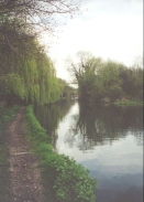
The section of towpath from Uxbridge to Rickamsnworth is very attractive, and it is hard to imagine that you are on the outskirts of London. On the left hand side of the canal are a series of abondoned cravel puts, now flooded and lakes, one of which is a nature reserves run by the Hertfordshire and Middlesex Wildlife Trust.
Batchworth Locks is actually two sets of locks; the right-hand one carries the Grand Union Canal, and the left hand one descends down to the River Chess. There was a very nice cafe by Batchworth Lock in Rickmansworth, and I stopped here for a quick sandwich under some canvas that was stretched between poles on ana island between the locks. It made for a very enjoyable location, and he rest allowed me to regain some strength ready for the rest of the walk.
The end of the walk between Watford and Kings Langley was far less picturesque as it passed under a branch of the M25 motorway, an A road and the M25 itself in clode succession and the roar of motor vehicles is never really left. If you avoid gazing upwards towards the roads and look to the fields alongside the canal then the section becomes more bearable; the livestock in the fields must get used to the noise at an early age.
Directions
The directions for this walk are very simple. Turn left out of West Drayton Station and walk to the end of the road. At a T-junction turn right and after a very short distance a bridge over the canal is found. The steps down to the canal towpath can be found on the far (northern) side of the bridge on the right-hand side of the road. When you reach the towpath turn right and head under the bridge.
It is now simply a case of following the canal as it heads northwards, squeezed between the M25 and the westernmost boundary of London. Uxbridge is the first settlement reached, and there is a nice pub right next to the towpath in the centre of the town.
From Uxbridge the canal passes northwards through a rural area and under a large but graceful brick railway viaduct before turning northeastwards to Batchworth, on the southern edge of Rickmansworth.
The canal continues northeastwards from Rickmansworth, but soon turns northwards past Cassiobury Park and the edge of Grove Park before passing under a series of bridges carrying the M25 and other roads. The last two of these bridges is a twin viaduct, and soon Home Park Farm Lock is reached. Leave the towpath at the lock and climb onto the bridge above it. Turn east down this road past some industrial buildings until a T-junction is reached. Turn right down this road and walk a very short distance to Kings Langley Station.
Further information
|
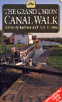
The walk is also covered in detail in the Grand Union Canal Walk, by Anthony Burton and Neil Curtis, ISBN 1 85410 244 3, published by Aurum Press Ltd. Click on the image to the right to go the Amazon page for this book.
For more details on the Grand Union Canal see Jim Shead's canal pages. |
|
Distances
| From | To | Distance (m) | Ascent (ft) | Descent (ft) |
|---|---|---|---|---|
| West Drayton | Uxbridge | 2.7 | 36 | 30 |
| Uxbridge | Rickmansworth | 7.3 | 125 | 79 |
| Rickmansworth | Kings Langley | 6.6 | 184 | 89 |
This makes a total distance of 16.6 miles, with 345 feet of ascent and 198 feet of descent.
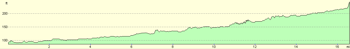
For more information on profiles, ascents and descents, see this page
Transport
West Drayton Station is served by trains out of Paddington, and Kings Langley by trains to Euston. Therefore travel between the two involves going into the centre of London and a train journey, a time-consuming exercise.
Disclaimer
Please note that I take no responsibility for anything that may happen when following these directions. If you intend to follow this route, then please use the relevant maps and check the route out before you go out. As always when walking, use common sense and you should be fine.
If you find any information on any of these routes that is inaccurate, or you wish to add anything, then please email me.
All images on this site are © of the author. Any reproduction, retransmissions, or republication of all or part of any document found on this site is expressly prohibited, unless the author has explicitly granted its prior written consent to so reproduce, retransmit, or republish the material. All other rights reserved.
Although this site includes links providing convenient direct access to other Internet sites, I do not endorse, approve, certify or make warranties or representations as to the accuracy of the information on these sites.
And finally, enjoy your walking!
This walk was mentioned in the following routes:
| Grand Union Canal Walk |
Nearby walks
| # | Title | Walk length (miles) |
|---|---|---|
| 60 | Slough to Alperton | 16.7 |
| 62 | Marlow to Slough | 16.3 |
| 130 | Tring Station to Hemel Hempstead Station | 8.0 |
|
|

|