Walk #140: Kings Langley to Hemel Hempstead
 |
 |
|
General Data
| Date Walked | 26/05/2001 |
| County | Hertfordshire |
| Start Location | Kings Langley Station |
| End Location | Hemel Hempstead Station |
| Start time | 14.23 |
| End time | 15.46 |
| Distance | 4.2 miles |
| Description | This was a short walk to connect up two stages of my walk along the Grand Union Canal that I have already completed. |
| Pack | I did not carry a rucksack today. |
| Condition | I was slightly worried about my ankle after an injury I obtained during my holiday to Australia, so I wore my trainers and carried no pack over this short distance. Fortunately it was okay and gave me no trouble, so I shall try a more strenuous walk next time. |
| Weather | It was a lovely day, with some hazy cloud causing the sun to be not as strong as it could have been. The temperature was about 25 degrees celsius, which is warmer than I normally like to walk in, and there was no sign of any rain. |
| OS map | Landranger number 166 (Luton & Hertford, Hitchin & St Albans) |
 |
Map of the walk
Maps courtesy of Google Maps. Route for indicative purposes only, and may have been plotted after the walk. Please let me have comments on what you think of this new format. For a detailed table of timings for this walk, please see the table file.
Notes
Due to a three-week trip to Australia this was my first walk for a few weeks. There was this little four or five mile section of my Grand Union Canal walk to be completed after I had done the sections from West Drayton to Kings Langley and Tring to Hemel Hempstead. I was due to pick my girlfriend up from Heathrow in the early evening, and since this walk is near to there I decided to do it before I went to pick her up.
This walk was one of the shortest 'official' (i.e. logged) walks that I have done, but it was necesary to complete this section of my walk along the Grand Union Canal. The drive up to start the walk was in itself interesting - from Cambridge I went down the M11 and then headed west along the M25, intending to park my car at Kings Langley. Unfortunately the M25 got very congested and slow, so I re-evaluated my plan and left at Junction 22 to head to Hemel Hempstead. After encountering an interesting junction in the centre of Hemel Hempstead I eventually found the station, but the only car park that I could find was a short term stay only. I then drove down to Kings Langley, and could not find a car pak there, so I drove on a bit further and parked up on a hill.
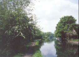
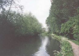
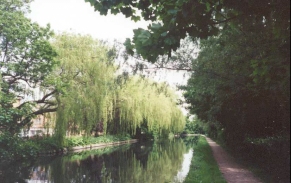
The weather today was lovely, and all the world and his dog appeared to be out on the canal towpath. At every lock there were children splashing in the water and other in little inflatable dinghys, all enjoying the glorious temperatures. The canal itself also looked lovely in the sun, with blossom in the trees reflecting in the water to make for some very picturesque locations despite there being some industrial locations on the route.
When I walked the last section from West Drayton to Kings Langley about a month previously, a cyclist told me that there was a section of the canal towpath south of Hemel Hempstead that was closed off. There was nothing on the British Waterways website showing this stoppage, so I assued that it had finished. Unfortunately between Nash Mill Top Lock and Apsley Lock the towpath was blocked off by the works for a new housing estate. The houses are being built on the site of the old Dickinson's paper mills, and although there were some half-completed houses on site the remains of the old buildings could still be seen from the road.
Quite why the towpath had to be blocked off for such a long period when houses were being built I do not know. Fortunately there was a good diversion that could be made via a footpath that led up to a road, and another that led back to the canal near a supermarket and Apsley Lock. The British Waterways website is good, but it would be nice if it could also include towpath stoppages as well as actual canal stoppages.
I have now completed all of the Grand Union Canal walk from the centre of London to Tring, and so it now a case of extending the walk northwards, probably initially to Bletchley (just south of Milton Keynes). This will leave just over seventy miles walking to do to get to Birmingham, which should be easily achievable before the end of the year (as long as there are no more closures of the towpath). I still have much walking to do if I want to get to Birmingham this year - I need at least six more days to be able to do it easily.
At the end of the walk I had to wait a while on Hemel Hempstead Station for the next stopping train back to Kings Langley. Whilst I was on the station I noticed the entrance to the long-stay car park at the south end of the station - all the driving that I had done earlier in the day had been unnecessary after all!
Directions
I had to park my car about a quarter of a mile away from King's Langley Station because I did not see the car park associate with the station (see above), but the descripton of this walk starts at the railway station itself.
Leave King's Langley station and go to the road. Turn right along the road northwards. Take the first road to the left and head down the slight hill and pass over the canal by a bridge. Once you have padded over the canal turn right and descend to Home Park Farm Lock below.
When you meet the canal turn left and head north along the canal. After about three quarters of a kilometre turn right onto a road bridge and then turn left to follow the eastern side of the canal. Continue northwards along the canal past the northern outskirts of Kings Langley.
After a short while you pass under the West Coast Main Line as it passes overhead on a skew bridge. Shortly after this on the outskirts of Hemel Hempstead the canal towpath swaps over from the eastern side of the canal to the western side. Immediately after this I had to make a diversion down a footpath to the east to avoid a new housing development on the site of the old Dickinson's paper mills, but I assume that by the time you read this the towpath has been reopened.
The towpath continues on the western bank of the canal for about two kilometres passing close to the A41(T) and Apsley railway station, so if you want to cut this walk short (or finish if you have walked here all the way from West Drayton by extending walk 139). At another bridge the towpath changes from the western bank of the canal to the eastern for abput half a kilometre before swapping back to the western bank. From here the canal slowly starts to curve around from a northwesterly heading to a westerly heading. As it does so it passes under a couple of main roads (the A4146 and the A414) as it approaches the Boxmoor area of Hemel Hempstead. After the A4146 bridge the area to the left starts to open out into an area of common land that is sandwiched between the canal and the A41(T).
When Fishery Lock is reached turn left and join the road that passes over the lock. Head south down this road until after about a hundred yards a gate is reached on the left. Take the path that leads across the common to another road, where a pedestrian crossing leads across the A141(T) to Hemel Hempstead railway station.
Further information
|
The walk is also covered in detail in the Grand Union Canal Walk, by Anthony Burton and Neil Curtis, ISBN 1 85410 244 3, published by Aurum Press Ltd. Click on the image to the right to go the Amazon page for this book.
For more details on the Grand Union Canal see Jim Shead's canal pages. |
|
Distances
| From | To | Distance (m) | Ascent (ft) | Descent (ft) |
|---|---|---|---|---|
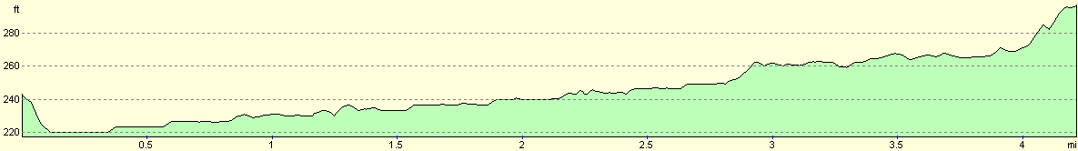
| Kings Langley Station | Apsley Station | 2.6 | 62 | 59 |
| Apsley Station | Hemel Hempstead Station | 1.6 | 72 | 23 |
This makes a total distance of 4.2 miles, with 134 feet of ascent and 82 feet of descent.
For more information on profiles, ascents and descents, see this page
Transport
There are regular train services from Hemel Hempstead to Kings Langley, calling at Apsley Station en route. There are also some bus services linking the two stations.
Disclaimer
Please note that I take no responsibility for anything that may happen when following these directions. If you intend to follow this route, then please use the relevant maps and check the route out before you go out. As always when walking, use common sense and you should be fine.
If you find any information on any of these routes that is inaccurate, or you wish to add anything, then please email me.
All images on this site are © of the author. Any reproduction, retransmissions, or republication of all or part of any document found on this site is expressly prohibited, unless the author has explicitly granted its prior written consent to so reproduce, retransmit, or republish the material. All other rights reserved.
Although this site includes links providing convenient direct access to other Internet sites, I do not endorse, approve, certify or make warranties or representations as to the accuracy of the information on these sites.
And finally, enjoy your walking!
This walk was mentioned in the following routes:
| Grand Union Canal Walk |
Nearby walks
| # | Title | Walk length (miles) |
|---|---|---|
| 130 | Tring Station to Hemel Hempstead Station | 8.0 |
| 139 | West Drayton to Kings Langley | 16.6 |
| 210 | Rickmansworth to Stanmore via Middlesex's highest point | 9.2 |
|
|

|