Walk #152: Kings House Hotel to Kinlochleven
 |
 |
|
General Data
| Date Walked | 23/08/2001 |
| County | Highlands |
| Start Location | Kingshouse Hotel |
| End Location | Kinlochleven |
| Start time | 08.55 |
| End time | 13.15 |
| Distance | 8.7 miles |
| Description | This was a fairly boring walk after yesterday's great one, but it did have some notable highs, in particular the views north from the top of the Devil's staircase. The long descent down to Kinlochewe did not have miuch going for it, however. |
| Pack | Today I carried full Pennine Way-spec kit. |
| Condition | I feel okay after today's walk. My back gave me no more trouble which was a great relief, a fact that I put down to the Savlon that I had been rubbing into it for the previous couple of days. I can only hope that it continues to give me no more trouble for the final day tomorrow. My legs are also fine, although my feet suffered once again due to the stoney paths. Fortunately they were not as uncomfortable as they had been earlier in the trip. For the first time on this trip my ankle started aching during the long descent down to Kinlochleven. |
| Weather | The weather today was just right, with a mixture of sunshine and cloud with absolutely no sign of any rain. There was not much wind which meant that at times it got quite hot, especially when the sun was shining. Aside from this there was nothing else of any note. |
| OS map | Outdoor Leisure number 38 (Ben Nevis & Glen Coe) and Landranger number 41 (Ben Nevis, Fort William & Glen Coe) |
 |
Map of the walk
Maps courtesy of Google Maps. Route for indicative purposes only, and may have been plotted after the walk. Please let me have comments on what you think of this new format. For a detailed table of timings for this walk, please see the table file.
Notes
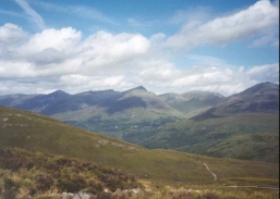
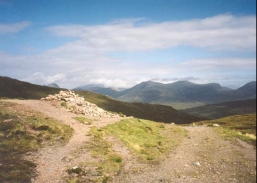
Two things dominated today's walk; the steep climb up the Devil's staircase and the long descent down to Kinlochleven. The former of these was a bit of a puff, and the latter was a long, hard slog along a rough path, but this was made up for by a brilliant view from the top, looking north towards Ben Nevis. On the climb up the Devil's staircase the people ahead of me looked like little ants climbing up the hill. One of the best bits about reaching the top was being able to look down the zigzigs on the hillside and be glad that I was not one of the people facing the climb up it.
There was a Malaysian girl who I kept on bumping into on the walk today. I thoguht that she was just a short walker initially as she had only a shoulder bag with her, which is hardly normal walkig gear. However I found out later that she has walked the entire way like this, using the backpack service to have her gear shiped to her stopping place for the next night. She was ginding the descent down to Kinlochleven hard and she was limping slightly, so anothr walker gave her an aspirin and I lent her one of my walking poles for a while to help her.
The number of people who use the backpack service on the West Highland Way is amazing, and I must admit that I see this as cheating - if you are going to do a walk then it is best to carry all your gear if at all possible. I could be slightly hypocritical for syayin this, however, as I walked the last thre daysof the Pennine Way without my tent as I dropped that off with my parents in Bellingham. I carried all my other gear, however.
The B & B that I am staying in, Tigh na Cheo, is very nice but it is slightly to far out from the centre of the town for my liking. After I had had a bath I went back out to the Tailrace Inn where I chatted to a few people for a while and had a meal. I returned to the B&B at about 19.30, which was quite early in the evening as I want to have an early start tomorrow morning.
The midges as the Glen Coe campsite were amazing this morning - I got up early from the my tent and went for a walk along the track that leads to the east from the Kingshouse Inn, and when I got back at 07.45 one of the three 'serious' walkers whom I met the night before had a grey haze of midges around him. To escape them I went in and bought a breakfast - at seven pounds this was quite expensive, but it was better than waitingoutside with the midges. I cannot recall having seen midges this voracious, and a German girl got bitten all over her face and neck. The pervious night three young Canadians had been warned about the midges and they had laughed them off, saying that they had faced far worse beasts in the Canadian wilderness. Seeing them run around in the morning like demented madmen to escape the midges would have been funny if I had not been running around like one myself.
I found that the choice that I had to make this morning - whether to walk along the West Highland Way or via Blackwater Reservoir - was really a non-decision. The terrain looked fairly rough heading north from the Kingshouse, and I realsied that I would miss having people to chat to on the journey. So I decided to follow the West Highland Way and with hindishgt I am glad that I made that decision.
The latter stage of the walk was dominated by the pipeline carrying water down from the hills to supply the large hydro-electric plant in Kinlochleven, which had been part of an aluminium smelting plant in the town. The large Blackwater reservoir to the east had been built by the aluminium company to supply the plant, and the pipes carrying the water down the hillside were very large. At the bottom of the hill there was a massive and very impressive spray of water could be seen where the water left the plant and joined the river - I would not like to try and canoe in that area.
The old aluminium works in Kinlochleven closed the previous summer, and as I walked past many of the buildings were being demolished. Some others have been converted into a walker's bunkhouse for people doing the West Highland Way, and the turbne hall is being refurbished with a new set of alternators to supply a smelter in Fort William with power. Apparently Scottish Power wanted to buy the hydroelectic plant, but the owners were not interested in selling.
I must admit that I quite liked the town, despite the fact that it was obviously an industrial town. It is in a beautiful setting, and despite the closure of the aluminium smelter the people seemed quite upbeat. This made me feel quite positive, and I will hgave to visit the town again sometime, perhaps to walk up the valley to the east that leads up to Blackwater Reservoir.
Directions
Leave the Kings House Hotel and use the bridge that is just behind it to cross the river. Head north down a track until it ends at a T-junction with another track. Turn left down this track and follow it past Queenshouse. Shortly before it meets the A82(T) a path leads off to the right. This path follows the Old Military Road as it ascends to about 310 metres, before descending slowly to meet the A82(T) beside some woodland at Altnafeadh.
There is a section of a few yards where the track joins the road and you have only a narrow verge to go on. After the wooded area ends a path leads off the road and up the hill to the right. At first the ascent is gradual as it follows the Allt a' Mhain, but it soon steepens and the path starts to zigzag as it ascends. This part of the path is known as the Devil's Staircase and is a surprisingly hard slog, but eventually the top of the climb is reached in a pass bewtween Stob Mhic Mhartuin to the west and Beinn Bheag to the east. At 548 metres this is the highest point on the West Highland Way, and there are some lovdly views available of the Mamores to the north.
From the top of the Devil's Staircase the path starts to descend. It crosses a couple of streams by fords as it heads north before it reaches the Allt a' Choire Odhair-mhoir. It then turns to a more northwesterly direction. It soon meets a house next to a tarmacced track at NN 202 605, which it immediately leaves as it turns sharply to the left. This is the start of a long slog downhill, a slog which is only enlivened by the bridge that passes the attractive waterfall and dam of the Allt Coire Mhorair.
From the bridge the track becomes less steep as it continues to descend, eventually meeting the pipeline that leads from Blackwater Reservoir to the east to Kinlochleven. The track then skirts to the left of the pipeline as they both descend to the old aluminium factory at Kinlochleven. At the factory the West Highland Way turns off to the right to cross the Rover Leven and enter the town by the northern bank; I chose with the people I was with to follow the track (which was by now a surfaced road) through the disused factory to the B863 at the road bridge over the River Leven. Turn right to cross the bridge and the Tailrace Inn is a short distance to the north along the B863.
For more details on this walk, look at the West Highland Way website.
Distances
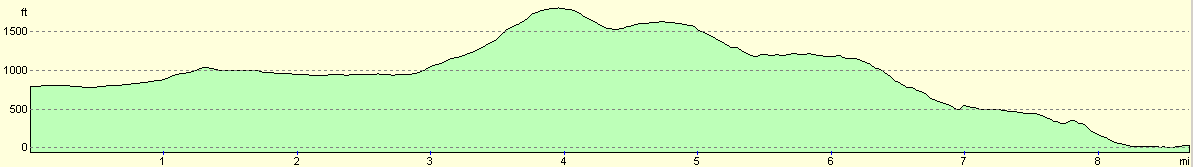
| From | To | Distance (m) | Ascent (ft) | Descent (ft) |
|---|---|---|---|---|
| Kingshouse Hotel | Allt a Choire Odhair-bhig | 4.0 | 1184 | 197 |
| Allt a Choire Odhair-bhig | Kinlochleven | 4.7 | 348 | 2093 |
This makes a total distance of 8.7 miles, with 1532 feet of ascent and 2290 feet of descent.
For more information on profiles, ascents and descents, see this page
Accommodation
I stayed at the Tich-na-cheo guesthouse, in Garbhein Road in Kinlochleven. Telephone 01855 831434 for more details. There is also what is apparently a very good bunkhouse in the grounds of the old aluminium works, and the bunkhouse also allows camping.
Disclaimer
Please note that I take no responsibility for anything that may happen when following these directions. If you intend to follow this route, then please use the relevant maps and check the route out before you go out. As always when walking, use common sense and you should be fine.
If you find any information on any of these routes that is inaccurate, or you wish to add anything, then please email me.
All images on this site are © of the author. Any reproduction, retransmissions, or republication of all or part of any document found on this site is expressly prohibited, unless the author has explicitly granted its prior written consent to so reproduce, retransmit, or republish the material. All other rights reserved.
Although this site includes links providing convenient direct access to other Internet sites, I do not endorse, approve, certify or make warranties or representations as to the accuracy of the information on these sites.
And finally, enjoy your walking!
This walk was mentioned in the following routes:
| My sectional Land's End to John O'Groats walk |
Nearby walks
| # | Title | Walk length (miles) |
|---|---|---|
| 151 | Bridge of Orchy to Kings House Hotel | 12.1 |
| 153 | Kinlochleven to Fort William | 14.1 |
| 154 | Ben Nevis from Fort William | 11.8 |
|
|

|