Walk #153: Kinlochleven to Fort William
 |
 |
|
General Data
| Date Walked | 24/08/2001 |
| County | Highlands |
| Start Location | Kinlochleven |
| End Location | Fort William (Ness bridge) |
| Start time | 08.00 |
| End time | 14.39 |
| Distance | 14.1 miles |
| Description | An initial steep climb is followed by a long slog along good tracks through some forested areas to Fort William. |
| Pack | Today I carried full Pennine Way-spec kit. |
| Condition | I feel totally knackered after today's walk. This walk really took it out of me for some reason, maybe because I put my foot down and hardly rested for the first three hours. The underside of my feet suffered on the sections of rough track, and indeed I nearly went over on my bad ankle once, the ensuing sharp pain causing an adrenalin rush to go through my body. The ankle is now acing slightly, but not enough to worry me overly. My back is once again fine which is a relief, as are my shoulders and legs. Last night I could hardly stop scratching at my midge bites, which consequently are now nice and red. |
| Weather | This was a fine, but generally overcast, day. There were some sunny periods, and this made it quite hot for short periods, as there was no wind to cool things down. Fortunately there was no sign of any rain, which would quite literally have put a damper on the end of the trip. |
| OS map | Landranger number 41 (Ben Nevis, Fort William & Glen Coe) and Outdoor Leisure number 38 (Ben Nevis & Glen Coe) |
Map of the walk
Maps courtesy of Google Maps. Route for indicative purposes only, and may have been plotted after the walk. Please let me have comments on what you think of this new format. For a detailed table of timings for this walk, please see the table file.
Notes
Well, the deed is done. After seven days walking I have reached my destination, and yet I feel no need to break out the glasses and open a bottle of champagne. All the walks on this trip were hard in their own ways, they all had some wonderful views and memories, and yet still I feel strangely unfulfilled. This is very different to the high I am normally on when I have finished a long walk - the exhilaration of reaching Kirk Yetholm at the end of the Pennine Way; the joy of getting to Taunton from Land's End, or the sheer relief of getting to Crieff. I think that this may be because I did not do the route that I was planning to do to get from the Kingshouse Hotel to Fort William and the fact that I think that I have compromised the walk in some way; this is probably unfair as I have still managed to walk to where I wanted to get to.
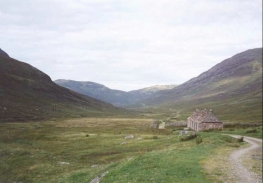
The old abandoned farm at Tigh-Na-Sleabhaich was fairly attractive, and would make a very nice place to camp in bad weather. It sits beside a section of the old military road, and I wonder what the farms relationship with the road has been over the years. It's name stands for "The house by the gullied slope", and apparently in 1983 it was a fairly decrepit bothy. A little further on are the ruins of Lairgmor cottage, which is now little more than a pile of stones.
I had a fairly early start today, and this allowed me to make the climb up the hill to the north of Linlochleven before 09.00. Because of this early start I had expected to be the first person up the hill in the morning, but wet boot prints on some stones showed that someone had been up to the top before me. When I reached the top I managed to catch a glimpse of a group of people in the distance, walking along the track about ten or fifteen minutes in front of me. When I saw them I decided to try and catch up with them to see if they were any of the people with whom I had been walking over the last few days. If you have ever tried actually walking to catch up with someone you will realise exactly how difficult it is; it was only when we got into the forested section of the walk that I managed to catch up with them, when it turned out to be a school party which I had encountered at the top of the Devil's staircase yesterday. I chatted to them for a while, and it turns out they were from Nottinghamshire, and one of the teachers even lived in the same street in Gedling as an old friend of mine. I was slightly staggered by this coincidence, and I let them walk on for a while before I set off again. Later on in the day when I was nearing Nevis Bridge at the end of the walk a couple of minibuses passed me in the opposite direction and they had the schoolchildren in them; they were obviously heading from the end of the walk back to their campsite in Glen Nevis.
As I was descending down the track to Glen Nevis a young lady with a heavy backpack was having trouble making her way up the hill. We exchanged the usual pleasantries, and it turns out that she was walking the West Highland Way, and was aiming to get to Kinlocheven that day. I hope that she made it okay - it was rather late in the day to be there considering the length of the journey that lay ahead of her.
I found the long trek down from the forest to Fort William to be quite boring, and I broke the journey in the Ben Nevis Visitors Centre for ten minutes. The only good thing to be said for this section of the walk was the magnificent views of the southern flank of Ben Nevis that were available - it has given me the idea that I may even climb it tomorrow. In order to make this feasible I went into town this afternoon after I had booked into the B&B so that I could buy a daysack to carry some stuff in - I do not fancy having to carry my 70-litre Craghoppers rucksack up to the top if I can avoid it.
Directions
This walk starts at the Tailrace Inn, just off the B863 in Kinlochleven. Turn left and head northwestwards along the B863 road though the town. At a bridge over the Allt Coire na Ba the road turns sharply to the left to head westwards. Follow the road as it does so and continue on along the road until you reach a school on the left.
At the school a signpost designates a path leading off up the hillside to the right. A West Highland Way fingerpost marks it, so it is easy to find. Take the path as it heads sharply uphill through a wooded area, crossing firstly one track and then another as it ascends. Eventually it leaves the wooded area and rises to meet another track, leading west from a TV station Ariel mast.
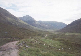
Join the track and turn left down it. The track, part of an Old Military Road, skirts the hillside to the north of the Allt Nathrach. Almost immediately the pretty Allt Coire na h-Eirghe stream is crossed, which is followed a little over a mile later by the Allt Coire a' Bhutha.
The track then continues for a further mile westwards until it reaches the old farm at Tigh-na-sleubhaich, next to where the Allt Coire na Sleubhaich comes down from Stob Ban to the north. This is the top of the valley, with the Allt Nathreach flowing to the east from here, and the Allt na Lairige Moire to the west.
From the buildings the track continues westwards across some fords for a little under a mile until another ruined building at Lairigmor is reached. This is very decrepit, even when compared to Tigh-na-sleubhaich, and comprised of little more than a jumble of fallen stones. The track continues along the southern flank of Meall Chaorainn and above the Allt na Lairige Moire as it turns from a westwards course to a northwesterly one until it meets a large forested area by a sheepfold at NN 101 649.
Enter the wooded area and follow the very obvious track as it heads northwards. After about a mile a break in the trees is reached, where there is a signboard and a short track leading down to a surfaced road. The road forms an alternative, shortened route to Fort William as it heads directly north into the town.
The official route continues from the signboard north-northeastwards, passing into the wooded area once more before emerging into a clearing. The path over the cleared area is fairly up-and-down fro just under a kilometre, before it plunges into another area of woodland.
Once the path enters the woodland it soon passes over the Allt Coire a Mhuilinn, where it turns to a northeasterly direction. A very short break in the woods is followed by another wooded area as the path heads to the crest of Sgorr Chalum. Eventually it turns to a northerly heading and passes just to the west of Dun Deardail, a prehistoric fort. This whole area is part of Nevis Forest, a large forested area on the southwestern side of Glen Nevis.
The path winds away until eventually it meets a wide unsurfaced track near the Allt Ghas-araich. Turn left and follow this track as it descends in a rough northerly direction. Just under a mile after the track is reached a junction is met with a track coming in from the right on a lower level; continue along these merged tracks to a junction with a track leading up Cow Hill.
Here a fingerpost indicates that the West Highland Way descends down to the right, heading eastwards across the Allt an Luid Dhuibh to meet the Glen Nevis Road. Turn left down this road and follow it as it heads northwards through Glen Nevis. Shortly after the road is reached the Ben Nevis Visitor Centre is on the right; this is a nice place to visit, particularly if you are going to climb Ben Nevis the next day. Further along the road is the 'Wishing stone', which is a big lump of stone beside the road. I do not know the history of this, but I touched it and made a wish nonetheless. The road then starts to swing northwesterly before ending up heading in a westerly direction at the end of the West Highland Way at Nevis Bridge.
For more details on this walk, look at the West Highland Way website.
Distances
| From | To | Distance (m) | Ascent (ft) | Descent (ft) |
|---|---|---|---|---|
| Kinlochleven | Tigh-na-sleubhaich | 3.7 | 1286 | 292 |
| Tigh-na-sleubhaich | Old Military Road | 3.8 | 207 | 617 |
| Old Military Road | Nevis Bridge | 6.6 | 912 | 1493 |
This makes a total distance of 14.1 miles, with 2405 feet of ascent and 2402 feet of descent.
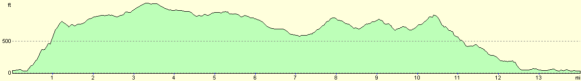
For more information on profiles, ascents and descents, see this page
Accommodation
I stayed in a B&B in Alma Road, right above the centre of the town and not far from the railway station. I think that the number of the house was number 60, but memory fails me. It is a shame as it was a very nice place, and I would like to be able to recommend it.
Disclaimer
Please note that I take no responsibility for anything that may happen when following these directions. If you intend to follow this route, then please use the relevant maps and check the route out before you go out. As always when walking, use common sense and you should be fine.
If you find any information on any of these routes that is inaccurate, or you wish to add anything, then please email me.
All images on this site are © of the author. Any reproduction, retransmissions, or republication of all or part of any document found on this site is expressly prohibited, unless the author has explicitly granted its prior written consent to so reproduce, retransmit, or republish the material. All other rights reserved.
Although this site includes links providing convenient direct access to other Internet sites, I do not endorse, approve, certify or make warranties or representations as to the accuracy of the information on these sites.
And finally, enjoy your walking!
This walk was mentioned in the following routes:
| My sectional Land's End to John O'Groats walk |
Nearby walks
| # | Title | Walk length (miles) |
|---|---|---|
| 152 | Kings House Hotel to Kinlochleven | 8.7 |
| 154 | Ben Nevis from Fort William | 11.8 |
| 185 | Fort William to Glenfinnan | 15.2 |
|
|

|