Walk #185: Fort William to Glenfinnan
 |
 |
|
General Data
| Date Walked | 20/04/2002 |
| County | Highlands |
| Start Location | Goisachan B&B, Fort William |
| End Location | Craigag Lodge (Glenfinnan) |
| Start time | 09.45 |
| End time | 15.25 |
| Distance | 15.2 miles |
| Description | This was a long road walk westwards out of Fort William, following the northern bank of Loch Eil. Despite the fact it was a road walk it was nonetheless enjoyable, with some lovely views available across the loch. |
| Pack | Full pack with twelve day's food. It weighs over 55 pounds. |
| Condition | I am relatively okay after this walk. My legs are slightly tired and my shoulders ache a little, but there is nothing that I am worried about. Late on in the walk whilst I was having a rest I noticed a hot-spot developing on my left foot, which I covered with a Scholl plaster. Apart from this minor problem I have no blisters. |
| Weather | The weather today was dominated by cloud, which when measured against the surrounding hills appeared to be at the 500 metre level. As soon as I left the B&B I was greeted with a light, spitting rain which continued for large portions of the day. Fortunately this light rain was not enough to get me wet, and when it started raining properly I was climbing up the driveway to the B&B. The temperature was reasonable, and I had no need to wear my fleece, managing with my coat over a base layer. |
| OS map | Landranger number 41 (Ben Nevis, Fort William & Glen Coe) and Landranger number 40 (Mallaig & Glenfinnan, Loch Shiel) |
 |
 |
|
Map of the walk
Maps courtesy of Google Maps. Route for indicative purposes only, and may have been plotted after the walk. Please let me have comments on what you think of this new format. For a detailed table of timings for this walk, please see the table file.
Notes
I went to breakfast at 08.00 this morning, and from there went for a walk around Fort William so that I could while away some time, as the B&B in Glenfinnan was not expecting me until 16.00. In Fort William I bought a half-litre fuel bottle and half a litre of meths, as I am worried that I may run out. I also finally managed to find myself a 'Gatekeeper' carbon filter which fits my Platypus bottles. This will allow me to purify any water that I find along the route, and acts as a backup the water purification tablets. I have been looking for a Gatekeeper for a few months, and have finally found a shop that stocks them.
I had been slightly concerned about today's walk, as it followed the A830(T) road for almost it's entirety. Fortunately I had nothing to worry about, as the traffic was very light and I never felt endangered. Unfortunately as it was a road walk it was tough on my feet, which were unsurprisingly aching by the end of the day. There was a pavement for pedestrians all the way from Fort William to just beyond the paper mill at Corpach, which was handy as that was by far the busiest section of road. Although the road was quiet it could well be busier later on in the year during the tourist season.
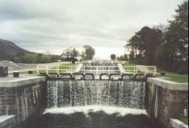
In Corpach I passed Neptune's staircase, a series of giant locks that carry ships up the Great Glen Canal. This was a very impressive sight, and although I wanted to explore it in more detail I decided not to as I did not want to unnecessarily tire myself out so early in the walk.
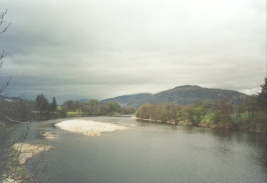
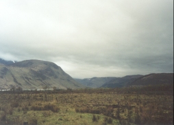
The walk along the A830(T) was not a bad as I was expecting, and there some very nice views available across to the southern bank of Loch Eil. Some of the hills and mountains on both side of the Loch were impressive and they looked very inviting, although not with a pack as heavy as the one that I was carrying! I will have to make another trip back to this area sometime so that I can explore them.
On the way out of Fort William I got to see the new Fort William turntable which had recently been built to turn the steam locomotives that regularly run to and from Mallaig. It is nice to see such historic items still being used for their intended purpose.
As I was walking along the A830(T) beside the railway and Loch Eil, Ben Nevis and Fort William were visible behind me. Fort William soon disappeared behind the Camusnagaul peninsula, but Ben Nevis remained stoically covered in mist. When I finally lost sight of the two of them I felt slightly sad, as I was having to say goodbye to two lovely places which I have a great fondness for.
At one stage a three-tonne lorry stopped and the two men inside the cab asked me if I wanted a lift to Mallaig. I rejected this kind offer, as not only was I not heading for Mallaig but getting a lift would definitely be cheating! This was a kind offer, and one that from past experience I dare say will be repeated many times over this trip.
This B&B is quite nice although understandably basic, and I had a very nice evening meal which saved me the walk in the rain to Glenfinnan village. The bed has electric blankets which I have not used for years, but which came in very handy on what was a cold night.
Tomorrow is the first of what should be four consecutive days in the wilds. It looks to be a fairly simple walk tomorrow, walking along the A830(T) to Glenfinnan and then heading north and climbing to 471 metres before descending down to Strathan. It should total 10.5 miles or thereabouts, which I may try to extend by a few mile if the weather is nice enough and I feel okay. Tomorrow is going to be a big day on this walk - if things go well then it will bode well for the rest of the journey.
Directions
This walk starts off at the Goisachan B&B, in Alma Road in Fort William. Leave the B&B and descend down the hill for a short distance until the road ends at a T-junction with the A82(T) at the bottom. At the junction turn right and follow the A82(T) eastwards out of Fort William until a roundabout is met by Ness Bridge.
At the roundabout turn left to follow the A82(T) as it heads northeastwards out of the town. A bridge carries the road over the Fort William to glasgow railway line before reaching a junction with the A830(T). At this junction turn left to take the A830(T) as it heads northwestwards over Victoria Bridge for about two kilometres until it passes over the bridge that carries the road over the Caledonian Canal, beside the dramatic flight of locks called Neptune's Staircase.
From here the road starts to swing around to a westerly heading, passing through the village of Corpach before meeting the northern side of Loch Eil and passing a very large paper mill. The pavement now ends, and the road continue northwestwards for three kilometres to the Loch Eil Outward Bound centre and it's associated station.
After the station the road continues westwards along the northern shore of the loch, passing the two junctions which lead to the little village of Fassfern and shortly afterwards the Locheilside Station. The road then passes Kinlocheil before reaching the junction with the A861 road, which follows the southern side of Loch Eil. Opposite the junction is a B&B, which may be a useful place to stop for the night.
From the junction the A830(T) continues westwards, again with the railway to the south but no longer with the loch, which has been replaced by a river. The road curves around and passes under the railway line. It then curves around again, and the entrance to the B&B that I stayed at is up the hill to the right, and is well signposted.
Glenfinnan itself is about a mile and a half further west along the A830(T) road. If you want another route from Fort William to the B&B, then one is mentioned in the excellent book "North to the Cape", by Denis Brook and Phil Hinchliffe, Published by Cicerone Press, and ISBN 1-85284-285-7. This route takes the ferry across the loch north from Fort William and then follows the A861 road west along the southern side of Loch Eil.
Distances
| From | To | Distance (m) | Ascent (ft) | Descent (ft) |
|---|---|---|---|---|
| Fort William Station | Neptune's Staircase | 2.6 | 135 | 177 |
| Neptune's Staircase | Loch Eil (Outward Bound) station | 3.9 | 184 | 197 |
| Loch Eil (Outward Bound) station | Locheilside Station | 3.7 | 210 | 203 |
| Locheilside Station | Craigag Lodge B&B | 5.0 | 440 | 351 |
This makes a total distance of 15.2 miles, with 969 feet of ascent and 928 feet of descent.
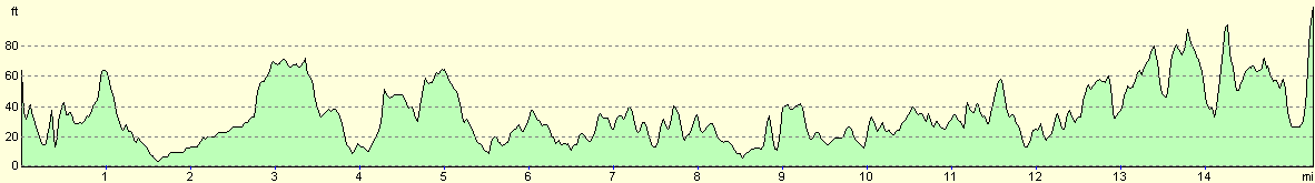
For more information on profiles, ascents and descents, see this page
Accommodation
I stayed at Craigag Lodge, which is about a mile to the east of Glenfinnan village. It's postcode is PH37 4LT, and it's telephone number is 01397 722240. A bed cost 20 pounds for the night, or 30 pounds with an evening meal.The evening meal is especially worthy of note - the starter was a rich and tasty tomato soup, which was followed by a beautiful braised venison with vegetables, with the pudding being an apple and raspberry crumble. The evening meal in itself was worth the stay at this B&B.
In Fort William I stayed at the Goisachan B&B, Alma Road, Fort William, PH33 6HA. Tel: 01397 703797. This was a nice and well-run establishment, although the food was not the nicest that I have ever encountered. It is very handy for the town centre and the railway station, and it cost 24 pounds for the night.
Disclaimer
Please note that I take no responsibility for anything that may happen when following these directions. If you intend to follow this route, then please use the relevant maps and check the route out before you go out. As always when walking, use common sense and you should be fine.
If you find any information on any of these routes that is inaccurate, or you wish to add anything, then please email me.
All images on this site are © of the author. Any reproduction, retransmissions, or republication of all or part of any document found on this site is expressly prohibited, unless the author has explicitly granted its prior written consent to so reproduce, retransmit, or republish the material. All other rights reserved.
Although this site includes links providing convenient direct access to other Internet sites, I do not endorse, approve, certify or make warranties or representations as to the accuracy of the information on these sites.
And finally, enjoy your walking!
This walk was mentioned in the following routes:
| My sectional Land's End to John O'Groats walk |
Nearby walks
| # | Title | Walk length (miles) |
|---|---|---|
| 153 | Kinlochleven to Fort William | 14.1 |
| 154 | Ben Nevis from Fort William | 11.8 |
| 186 | Glenfinnan to A'Chuil Bothy | 12.8 |
|
|

|