Walk #186: Glenfinnan to A'Chuil Bothy
 |
 |
|
General Data
| Date Walked | 21/04/2002 |
| County | Highlands |
| Start Location | Craigag Lodge (Glenfinnan) |
| End Location | A' Chuil Bothy |
| Start time | 09.26 |
| End time | 15.45 |
| Distance | 12.8 miles |
| Description | This was a very hard day's walking, starting off with an easy walk along the A830(T) road, and then an ascent to the Bealach at 471 metres, and a hard descent down Gleann a' Chaorainn. |
| Pack | Full pack with twelve day's food. It weighs over 55 pounds. |
| Condition | I found this walk very hard, not the least due to the awful weather. My feet are okay, as are my shoulders and various other parts of my anatomy, but I am cold and damp. Unfortunately I did slightly twist my ankle during the descent. This is now aching, enough to worry me rather than cause me any significant pain. I also had problems with tightness in my left leg thigh muscles during the descent which was annoying. The biggest problem is my right knee, which I hurt during the little incident that I had on the descent. |
| Weather | The weather started off with a little drizzle, which packed in by the time I reached Glenfinnan. The ascent up to the bealach was spitting with rain, but during the long and hard descant it started to solidly rain. This led to everything that was not in a bag getting wet. The wind was quite fierce in exposed places, which did not help matters, and there was about ten minutes of lightning and thunder when I was near the top. All in all it was very miserable weather. |
| OS map | Landranger number 40 (Mallaig & Glenfinnan, Loch Shiel) |
 |
 |
|
Map of the walk
Maps courtesy of Google Maps. Route for indicative purposes only, and may have been plotted after the walk. Please let me have comments on what you think of this new format. For a detailed table of timings for this walk, please see the table file.
 |
Notes
This was a highly unenjoyable day, which was made so by the damp weather and boggy, unyielding terrain. I also have had probably the most frightening experience that I have ever had on the hills, but I do not really want to write about that at the moment.
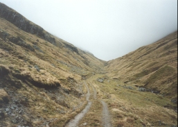
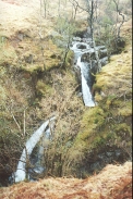
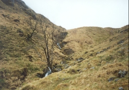
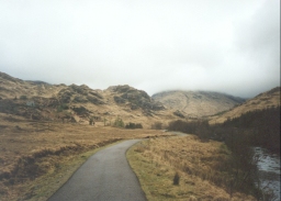
The ascent from Glenfinnan to the Beach was fairly straight forward, with tarmac up as far as the bothy at Corryhully being replaced with a good firm track almost all the way up to the top. Unfortunately the descent was very hard, with the path being non-existent for large portions of the way and at others taking you actually through the wide stream on boulders. The most dramatic part was late on, where the path dipped and then rose past a magnificent waterfall as the stream plunged though a deep gully. Unfortunately I was too busy trying not to slip again on the soaking mud and grass to stop and admire the view.
As the path approached Glen Pean the stream had to be crossed to get to the bridge over the River Pean. Unfortunately I probably chose to do this too late, but I managed to get across without adding any more water to my already saturated boots. This crossing was actually quite enjoyable, even though the river was fairly high due to the rain.
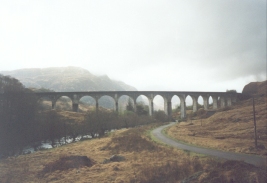
Glenfinnan was quite nice, and I walked up to the '45 monument to have a closer look, although I did not bother to climb up it. I also passed under the concrete viaduct, which is a very impressive structure. Indeed it is sad thing to say, but these two items were really the highlights of the day. If the weather had been nicer then I have little doubt that the climb would have been the highlight, but unfortunately that was not to be.
Today was really spoilt by the weather - it made what should have been a hard and strenuous yet enjoyable walk into a real feat of endurance. The thunder and lightning was quite impressive when I look back on it, but being in it at the time was quite concerning. I was in a cloud layer which provided a slightly misty look and the whole vista around me was lighting up blue and white when the bolts struck. This really made me want to get down off the hill fast, which in the conditions was probably not a wise decision.
Today was far from enjoyable on the whole, and I have to decide what to do tomorrow. I have two options; the first is to continue on the route that I had planned, and the other is to return to Strathan and then follow the pubic road for the 23 kilometre back to the south eastern end of Loch Akraig at Achnacarry. The first option would be my preferred one, as it means that I am doing what I set out to do. It does mean, however, that I will be leading myself out into even more remote areas which means that if I get into difficulty I could have trouble getting out. The second option is by far the safer, as it involves a road walk along a public road. If I did not manage to do it in one go I could always camp somewhere along the road or even hitch-hike back to safety. The second option does, however, lead me in totally the wrong direction, back to the Great Glen about ten miles Northeast of Fort William.
I think that I will wait until the morning and then see what the weather is like. If it is raining and cloudy, then I shall take the second option and try to find a way north from Achnacarry. If it is sunny and the cloud level is high, I shall continue on along the proper route. Whatever option I choose to do I shall write it down in the bothy's book, so it is recorded. This decision will also be dependent on my condition, and my right knee has slowly become increasingly stiff as the evening has gone on. I could really do with a bath to soak it in to see if that will help it, but of course there is no access to baths in bothies!
The only good thing about today is that I managed to walk a few extra miles to this bothy - it is much preferable to camping out. For tea I had some Uncle Ben's Quick Cook rice, a Snickers Bar, and some pasta cup-a-soup which was all washed down with some coffee. In a break in the rain I went outside and gathered up some firewood and I then lit a fire, which helped cheer me up no end. It did not last long, But it was enough and I managed to dry out some wood for whoever stays here next.
The bothy is very nice in a basic way, and I am very glad I made the decision to walk on the extra couple of miles from Strathan. There were two possible routes to get to the bothy; the first went via Glendessary on the northern side of the valley and the second went through the forestry on the southern side. I chose the latter as although it went up and down more it was more direct. About two-thirds of the way along the track I came across a place where a large landslip had taken away the road. The landslip consisted of thick, oozing mud with conifers sticking out of it at crazy angles. This all took a little time to get through, but I managed it with nothing more than muddying my already soaking boots.
it is now the next morning, and the weather is just as bleak as it was last night. My right knee is also quite sore and stiff, so I feel that to try to continue to the next bothy is too risky - if only I had access to a long-range weather forecast! For this reason I have reluctantly decided to try to head for Achnacarry tonight, which will be a long walk and I will not be guaranteed a B&B. But at least I will not be going out any further into the wilderness.
The following was written in the bothy book 2/9/01:
You know the tune:

If I die before I wake,
at least I won't have another river jump to make.
Cos right here on earth I can't jump back
Not with this rucksack on my back

If I die before I wake,
At least I'll be dry for heaven' sake,
Cos right here on Earth I'm all wet,
And I've a long way still to get

I'll climb up the top of a mountain,
Right on top of the rocks,
And then I'd be in heaven,
with Jesus drying my socks

But when I get to the pearly gates
There's a sign saying, no walking mate!
so I'll walk the hills and have a ball,
Cos there's hardly any gates at all.

If I die before I wake,
At least I'll be dry for heaven' sake,
Cos right here on Earth I'm all wet,
And I've a long way still to get

Here I'm surrounded by geology
I've got the hills,
I've got the hills,
Heaven is a bothy!
Directions
This walk starts off at the Craigag Lodge B&B, which is one and a half miles to the east of Glenfinnan. You could also start at Glenfinnan itself, in which case ignore the first part of these directions.
Leave the B&B and descend down the driveway to meet the A830(T)road. When the road is reached turn right and follow the A830(T) as it heads northwestwards for a mile and a half towards Glenfinnan.
Pass to the right of the Glenfinnan Monument and then continue on to cross the bridge that carries the road over the River Finnian. Immediately on the far, western, side of the bridge turn right and head northeastwards along a tarmac road along the western bank of the river. This track passes under the impressive Glenfinnan Viaduct before heading to turn northwards. Follow it for about three kilometres from the viaduct until it crosses the Allt a' Chaol ghlinne. Immediately on the northern side of this bridge turn right along a track that leads to the bothy at Corryhully. Do not continue on along he tarmac road, which leads to Glenfinnan Lodge.
From the bothy follow the track as it turns northeastwards and slowly starts to ascend. A bridge carries the track over another stream before the ascent starts to steepen as it starts to head up to the bealach between the two Munros of Sgurr Thuilm to the north and Streap to the south. Near the top the track ends and becomes a defined path to the top of the pass.
From here the path becomes far less defined as it passes over the boggy bealach. On the northeastern side of the bealach the route follows the western side of the Allt a' Chaorainn as it starts to descend. There is no path here (*), and the going can be quite tough and steep in places, so be careful in bad weather. Stick to the western side of the stream as it descends, but be careful of an area where the stream descends down into a gully, and the path becomes defined on a narrow ledge above the stream.
Eventually the steepness of the descent starts to slacken, and you then need to cross over to the eastern side of the stream before it ends at the River Pean. The streambed is covered in boulders, which aids considerably in doing this. Once over on the other side continue the descent down to the place where the stream and the river meet. Turn right and follow the river downstream for a very short distance to a bridge over the river. Cross the bridge to the northern side of the river.
Once on the other side turn left and follow the river upstream for a short distance, before turning right to head uphill to the north into some woodland. Once in the woodland continue northwards for about a hundred metres until you hit a forestry track. I managed to find a very boggy path through the trees that led northwards in just the right place.
Once on the forestry track turn right and follow it eastwards and then northeastwards through the forest. At a junction with another track turn left and head uphill to the north (if you want to go to Strathan then continue for about a quarter of a mile northeastwards on the original track).
The track starts to ascend as it heads northwards through the forest. As it does so it starts to run to a more westerly heading along the southern side of the River Dessary. It reaches a maximum height of about 140 metres as it heads westwards. Shortly before the track leaves the forest at NM 943 924 a path leas downhill for about a hundred yards to the A' Chuil bothy.
The part of this walk from Glenfinnan to the River Pean is shown as Variant 2 in the excellent book "North to the Cape", by Denis Brook and Phil Hinchliffe, Published by Cicerone Press, and ISBN 1-85284-285-7.
(*) Many thanks to Moray Stewart, who had the following to say:
I see your section - "From here the path becomes far less defined as it passes over the boggy bealach. On the northeastern side of the bealach the route follows the western side of the Allt a' Chaorainn as it starts to descend. There is no path here, and the going can be quite tough and steep in places, so be careful in bad weather. Stick to the western side of the stream as it descends, but be careful of an area where the stream descends down into a gully, and the path becomes defined on a narrow ledge above the stream."
I would actually recommend going down the East side of Allt a' Chaorainn; there is no path but the going is easy - a gentle slope down to the River Pean. The path on the west side has worsened and at one point has dangerously fallen away. Last time I was up this way I had a vertigious chap in the group so I decided to head down the east side and was surprised that it's actually easier and quicker! Just a thought...
Distances
| From | To | Distance (m) | Ascent (ft) | Descent (ft) |
|---|---|---|---|---|
| Craigag Lodge (Glenfinnan) | Glenfinnan | 1.5 | 164 | 233 |
| Glenfinnan | 471 metre summit | 5.1 | 1732 | 217 |
| 471 metre summit | Glen Pean | 3.0 | 46 | 1404 |
| Glen Pean | A'Chuil bothy | 3.2 | 545 | 407 |
This makes a total distance of 12.8 miles, with 2487 feet of ascent and 2261 feet of descent.
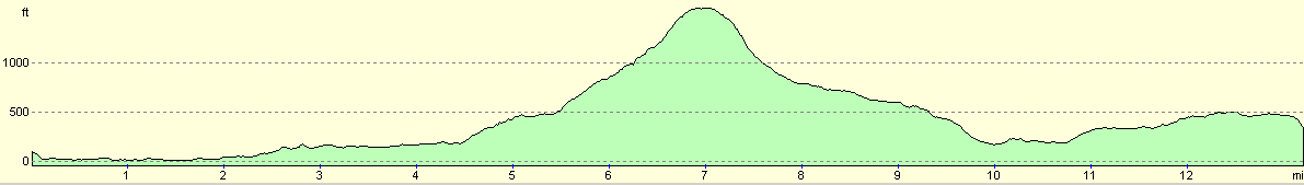
For more information on profiles, ascents and descents, see this page
Accommodation
I stayed at the A'Chuil bithy, which is run by the Mountain Bothies Association. There is another bothy nearby in Glen Pean.
Disclaimer
Please note that I take no responsibility for anything that may happen when following these directions. If you intend to follow this route, then please use the relevant maps and check the route out before you go out. As always when walking, use common sense and you should be fine.
If you find any information on any of these routes that is inaccurate, or you wish to add anything, then please email me.
All images on this site are © of the author. Any reproduction, retransmissions, or republication of all or part of any document found on this site is expressly prohibited, unless the author has explicitly granted its prior written consent to so reproduce, retransmit, or republish the material. All other rights reserved.
Although this site includes links providing convenient direct access to other Internet sites, I do not endorse, approve, certify or make warranties or representations as to the accuracy of the information on these sites.
And finally, enjoy your walking!
This walk was mentioned in the following routes:
| My sectional Land's End to John O'Groats walk |
Nearby walks
| # | Title | Walk length (miles) |
|---|---|---|
| 185 | Fort William to Glenfinnan | 15.2 |
| 187 | A'Chuil to Gairlochy | 22.9 |
| 490 | Fort William to Camusnagaul | 22.4 |
|
|

|