Walk #187: A'Chuil to Gairlochy
 |
 |
|
General Data
| Date Walked | 22/04/2002 |
| County | Highlands |
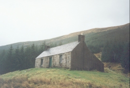
| Start Location | A' Chuil Bothy |
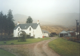
| End Location | Gairlochy B&B |
| Start time | 09.20 |
| End time | 18.25 |
| Distance | 22.9 miles |
| Description | This walk started off in boggy ground, which was followed by a short walk along a track and then a long, long walk along a road on the north side of Loch Akriag. another walk then followed to the B&B to the south of Gairlochy. |
| Pack | Full pack with eleven day's food. It weighs over 55 pounds. |
| Condition | I am in a reasonable condition after the travails of yesterday and the very long walk today. I have a hot-spot on my right foot and some chafing around my waist which was caused by my rucksack getting slightly out of position. My bad ankle is aching and so is my right knee which I hurt yesterday. Generally I am fairly stiff and have slight aching in some joints, but all in all I am quite pleased with how I feel after the distance I have walked. I also have a big bruise and sore point on the right-hand side of my waist, which could cause problems with my pack tomorrow. |
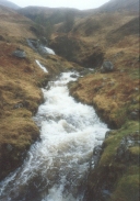
| Weather | When I woke up the weather was bad, with rain streaming against the bothy roof and the stream running beside it being very full. The rain was not too strong when I initially set out, but soon after I started along the road it became much stronger and I soon got soaked. This continued for hours, until eventually it started to ease, and after a few false starts it started to brighten up. Light drizzle was then interspersed with sunny periods. Eventually the drizzle stopped by the time I reached the eastern end of Loch Akraig and it was replaced with sunshine and cloud, which helped me dry out slightly. |
| OS map | Landranger number 33 (Loch Alsh, Glen Shiel & Loch Hourn) and Landranger number 41 (Ben Nevis, Fort William & Glen Coe) |
 |
 |
|
Map of the walk
Maps courtesy of Google Maps. Route for indicative purposes only, and may have been plotted after the walk. Please let me have comments on what you think of this new format. For a detailed table of timings for this walk, please see the table file.
Notes
This was an exceedingly long and tiring walk, which was made worse by the fact that the vast majority of it was along tarmac roads. The walk could have been much better if the weather had been better and the views more expansive but due to the driving rain at times I could not even see the other side of the loch.
I found this walk to be very depressing, with the weather preventing me from taking regular breaks and the constant rain dragging my mood down further. As soon as I got past Achnacarry I got a low signal on my mobile phone, so I phoned Sam up as I needed to hear a cheerful voice. This did the trick, and I decided to stop thinking about getting a lift and to keep on walking until I found a B&B.
At the start of the walk I had to decide whether to walk from the Bothy to Strathan along the forest track or to walk across the valley to Upper Glendessary and then along the track to Strathan. In the end I chose to walk the latter route as I had not done it before and it allowed me to avoid the landslip that I encountered in the forest yesterday. With hindsight this was a mistake, as the former route had to cross a very wet and boggy terrain to reach Upper Glendessary and the streams were all in spate, which complicated crossing them somewhat. When I reached Upper Glendessary the track was still rough and boggy almost all the way to Strathan.
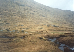
The road eastwards from Strathan along the northern bank of the loch was fairly windy, and it was disappointing to find that it constantly climbed and fell as it followed the loch. Some of these climbs were fairly steep, and in the rain they were not very enjoyable. This road was very quiet - in the first few hours I saw only two cars, and these wee both heading in the opposite direction. The road got busier as I headed towards the end of the loch, with forestry and salmon farm traffic going to and fro.
My main aim had been to walk as far as Achnacarry, and then find some accommodation somewhere in that area. Unfortunately there was none, so after further enquiries I decided to walk on to Gairlochy, where I had been told that B&B was available. When I reached that village in a very tired state I found out that the B&B was another three-quarters of a mile down the road! When I got there I knocked on the door and the landlady told me that due to a recent bereavement she was not doing B&B until tomorrow. Looking at my bedraggled state she took pity on me and let me in, which was nice. I had a long soak which was followed by an evening meal, and about 22.00 there was another knock on the door and an American hiker came in. Such kindness as displayed by the landlady is very well received.
Tomorrow I shall probably try and have an easy day and walk down the Great Glen Way to Laggan or Invergarry. That will then leave me able to walk further down the Great Glen towards Inverness, or to walk along the A87 to Cluanie Inn and then Shiel Bridge.
Unfortunately the weather forecast for tomorrow is for drizzle and light rain, which is exactly what I do not need after the last couple of days! Fortunately I have managed to dry out most of my wet clothes and so at least I will not have to start the day off wet, and I can save my spare sets of dry clothes for another day. After the disappointment of the last couple of days I could do with a nice day's walking to raise my spirits and to make me feel better about this trip. No rain would be a great help for a start.
Directions
This walk starts off at the A' Chuil bothy, on the southern side of the River Dessary in Glen Dessary. Leave the bothy and head northwestwards, crossing the stile over a fence and then two small streams. After the streams head to a more northerly heading to meet the River Dessary and eventually a bridge over the river at NM 943 929. Cross the bridge and then follow an indistinct path on the ground south-northwestwards to the building at Upper Glendessary. The going over this section was fairly boggy, and I found it easier to avoid the path and make my own route over the slightly higher, less boggy ground.
From Upper Glendessary a track leads eastwards along the northern bank of the river for about a mile to the farm at Glendessary. On the far side of the farm a bridge carries the track over the Allt na Feithe and it then turns southeastwards to head towards Strathan. At a junction do not descend down to Strathan but continue eastwards along the track that skirts to the north of the farm. The track becomes surfaced and eventually, after going though a gate, becomes a public road as it reaches the northern bank of Loch Akraig.
This road follows the northern bank of the loch for fourteen or fifteen miles, winding around and climbing and descending as it follows the loch. It is steep on places, but the road is very quiet and not dangerous. It passes Murlaggan, Caonich and Ardechive before the road eventually ends when it meets the B8005 road at the eastern end of the loch.
At the junction do not continue along the B8005 but turn right, to head south along the eastern edge of the loch. Cross a bridge over the River Akraig (apparently the shortest river in Britain) and then follow the road as it heads southeastwards into Achnacarry. Pass the museum and the post office and continue for a mile until the road ends at the B8005 once more. At the junction turn right and follow the B8005 as it heads southwards and then southwestwards along the western bank of Loch Lochy. When a road junction is met just above Gairlochy descend down into the village.
At another junction at the bottom of the hill turn left and cross over the Caledonian Canal using the B8004 bridge. The road curves around before joining the northern bank of the River Spean. A bridge carries the road over the outflow from Loch Lochy at the Bridge of Mucomir and the B&B is about a hundred yards ahead on the left.
Distances
| From | To | Distance (m) | Ascent (ft) | Descent (ft) |
|---|---|---|---|---|
| A'Chuil Bothy | Strathan | 3.1 | 282 | 371 |
| Strathan | Caonich | 6.0 | 515 | 610 |
| Caonich | Achnacarry | 9.4 | 640 | 653 |
| Achnacarry | Gairlochy | 4.4 | 387 | 322 |
This makes a total distance of 22.9 miles, with 1824 feet of ascent and 1956 feet of descent.
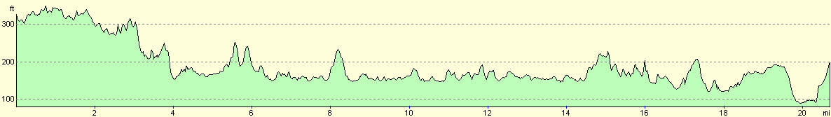
For more information on profiles, ascents and descents, see this page
Accommodation
I stayed at a lovely B&B which was about three-quarters of a mile south of Gairlochy. This was a very nice B&B, which caters for disabled and able-bodied people. It cost 25 pounds with an evening meal, which is not a bad price. The B&B is at OS grid reference NN 186 838, and is at Earendil, Mucomir, by Spean Bridge, PH34 4EQ. e-mail helen@dreamweavers.co.uk, or look on the web at www.fort-william.net/dreamweavers.
Disclaimer
Please note that I take no responsibility for anything that may happen when following these directions. If you intend to follow this route, then please use the relevant maps and check the route out before you go out. As always when walking, use common sense and you should be fine.
If you find any information on any of these routes that is inaccurate, or you wish to add anything, then please email me.
All images on this site are © of the author. Any reproduction, retransmissions, or republication of all or part of any document found on this site is expressly prohibited, unless the author has explicitly granted its prior written consent to so reproduce, retransmit, or republish the material. All other rights reserved.
Although this site includes links providing convenient direct access to other Internet sites, I do not endorse, approve, certify or make warranties or representations as to the accuracy of the information on these sites.
And finally, enjoy your walking!
This walk was mentioned in the following routes:
| My sectional Land's End to John O'Groats walk |
Nearby walks
| # | Title | Walk length (miles) |
|---|---|---|
| 185 | Fort William to Glenfinnan | 15.2 |
| 186 | Glenfinnan to A'Chuil Bothy | 12.8 |
| 188 | Gairlochy to Laggan | 14.5 |
|
|

|