Walk #188: Gairlochy to Laggan
 |
 |
|
General Data
| Date Walked | 23/04/2002 |
| County | Highlands |
| Start Location | Gairlochy B&B |
| End Location | Laggan |
| Start time | 10.13 |
| End time | 16.32 |
| Distance | 14.5 miles |
| Description | This was an easy walk following the Great Glen Way as it heads north-eastwards along the shores of Loch Lochy. There are some lovely views to be had across the loch at times through gaps in the trees. |
| Pack | Full pack. |
| Condition | My condition during today's walk was not good. My feet were aching terribly, which could be to do with the fact I put very damp socks on my feet in damp boots, and my back was itching, a recurrence of an old problem that I have had on some previous walks. I also found the last few miles very hard to do, and they consequently took much longer than normal to complete. This could just be a result of my long walk yesterday, so hopefully I will be in a better state tomorrow. My ankle hurt at times during this walk, and my right knee was aching on the ascents, both of which are slightly worrying factors. |
| Weather | When I left the door of the B&B it started to spit with rain, and this soon became a drizzle. Fortunately this stopped fairly soon, and I took my rucksack off at Achnacarry so I could put my coat on top. The rest of the day consisted of sunshine and cloud with a fairly tiff wind, which I was mostly protected from by the trees which surrounded the route. Fortunately there was no sign of any wind, so it gave me more of an opportunity to dry out. |
| OS map | Landranger number 41 (Ben Nevis, Fort William & Glen Coe) and Landranger number 34 (Fort Augustus, Glen Albyn & Glen Roy) |
 |
 |
|
Map of the walk
Maps courtesy of Google Maps. Route for indicative purposes only, and may have been plotted after the walk. Please let me have comments on what you think of this new format. For a detailed table of timings for this walk, please see the table file.
Notes
At breakfast I met the American gentleman who came in late last night. He had walked in from just above Glen Nevis on the West Highland Way, then walked into Fort William and then onto Gairlochy. Since we were chatting over breakfast, I set off later than I normally do and we set off walking together.
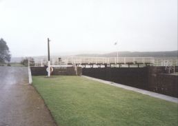
He was walking in the strangest way I have ever seen - he had a medium-sized backpack on his back, and in each hand he had a large holdall, which looked to me to be a very uncomfortable walking arrangement - personally I would much rather have my hands free and the weight on my back. At the lock in Gairlochy we spent twenty minutes walking around and trying to find the route of the walk - I wanted to continue along the road, for I had seen signs yesterday on my walk into Gairlochy, but the gent wanted to walk the entire route. eventually we discovered that the path followed the road so we started the ascent up the hill.
A short distance after the top of the hill the path descended to the bottom of the hill beside the loch. I decided to continue walking along the road, as I knew the two would eventually have to meet up once again. The American gent wanted to walk the proper route, so we said our goodbyes. At least I tried to - the gent started giving me a long lecture on the different type of coniferous trees that we were seeing along the route, and he seemed ecstatic at the sight of a Rowan. After ten minutes we eventually parted, and I was left thinking how boring hobbies seem to other people!
I found this walk very hard, and the last mile in particular was a a real chore to complete. My back was itching, so I will have to rub some Savlon into it tonight to ensure that a rash does not start forming. The biggest problem, however, were my feet, which were painful for the majority of the day. This morning I had made the decision to wear the damp socks that I had been wearing yesterday, and with hindsight this was very probably a mistake as my feet started itching very soon after starting out. Towards the end of the walk they were very painful, and every step hurt. Because of this my gait was slightly different from usual, and I believe that this may have had something to do with a little bit of pain that I had from my ankle.
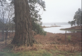
The views over Loch Lochy were very nice when they were visible through gaps in the trees. In bright sunshine I should think that the Loch looks spectacular - it was a shame that I did not get to se it in such conditions. There were the remains of some snow on the tops of some of the mountains, which really set off the scene well when I looked behind me.
The landlady of he B&B drove me for about a mile to a local holiday complex in the early evening so that I could have an evening meal and a drink. She then picked me up, which is what I call service! I have also hand-washed some socks, boxer shorts and a base layer which were wet, and have left them to dry. In the absence of any laundry facilities that will have to do.
I now have to decide what to do tomorrow. Yesterday I thought that I would walk up the A87 to Shiel Bridge from Invergarry, but I now quite fancy continuing along the Great Glen Way to Inverness and then see the best way of heading north-westwards from there, perhaps to Lairg. This means that tomorrow's walk would be eleven miles to Fort Augustus, or 18.5 to Invermoriston. If I feel anything like I did today, then the latter option will not be excised!
The American gent has just walked in and it is 21.45 - he apparently spent quite a while in the Cameron Museum in Achnacarry, but even so it has been quite a long day for him - nearly twelve hours! I am not sure whose approach I prefer - I bet that his feet do not hurt as much as mine! When he came in the door the first thing that he talked about where the various spruces were on the walk, not a subject that I was very interested in.
Anyway, in honour of the gentleman, here is some information about Scotland's forests, taken from various tourist information leaflets;
- 17% of Scotland is covered with woods and forests
- Forestry in Scotland employs 10.000 people.
- There are an estimated 2 billion trees in Scotland, an average of a football pitch of trees for every household.
- Each letter of the Gaelic alphabet is named after a tree.
- The oldest living organism in Europe is a yew tree in Fortingall, which is at least 3,000 years old.
- The tallest tree in the British Isles is a Douglas Fir near the Hermitage in Scotland. It is 64.4 metres tall.
- The tallest hedge in the world is the Meiklour beach hedge in Scotland, which is 30 metres tall.
- The widest conifer in Britain is at Cluny House Gardens, and has an 11 metre girth.
So there you go! That is surely more than enough to keep anyone interested!
Directions
This walk follows the newly-opened Great Glen Way north-eastwards, so navigation is very simple as the route is well waymarked, although I did deviate a little from the official route.
From Gairlochy locks cross the bridge over the canal and turn right to head uphill along the B8005 road. Initially this heads in a north-easterly direction, but at the summit a Great Glen Way trail marker points downhill. That route can be followed, but it meets up with the road later on so I stayed with the road, which was pleasantly quiet.
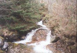
The road winds around the hillside through a forestry plantation, gaps in the trees giving tantalising glimpses of the southern reaches of Loch Lochy. Pass the junction with the road which leads up to Achnacarry which I walked up yesterday and continue on around a little bay to Bunarkaig. About a mile further on the road crosses the Allt Bhan burn near where it drains into the Loch at Clunes. Immediately after this the road bends sharply to the left; here a forestry road leads off to the right.
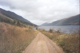
Turn right and follow the forestry road as it becomes a track and starts to climb through the forest. The way is very easy to follow as it heads north-eastwards along the northern shore of the Loch. After a long distance it makes one last ascent to meet another track coming in from the left before descending to meet a surfaced road at the Kilfinnan Burn.
Continue straight on along the road until you meet a junction. do not carry straight on along the hillside but take the road that leads off to the right past the holiday chalets. This road emerges at the two Laggan Locks.
Cross over the canal at either of the locks and then turn left, to head northwards along the eastern bank of the canal. When the path splits take the higher route which continues on top of a bank above the canal towpath for a mile until a wooden bridge is reached. Do not cross the bridge but turn right and walk the few yards to the main road. Here turn right and head south along it; the B&B that I stayed in is about fifty yards ahead, and the Scottish Youth Hostel is next door to it.
Distances
| From | To | Distance (m) | Ascent (ft) | Descent (ft) |
|---|---|---|---|---|
| Gairlochy | Clunes | 4.7 | 318 | 367 |
| Clunes | NN 240920 | 3.8 | 341 | 361 |
| NN 240920 | Laggan | 6.0 | 423 | 413 |
This makes a total distance of 14.5 miles, with 1082 feet of ascent and 1141 feet of descent.
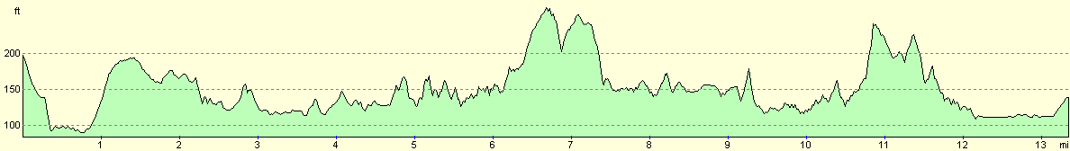
For more information on profiles, ascents and descents, see this page
Accommodation
The B&B that I stayed in is Lilac Cottage, South Laggan, by Spean Bridge, Inverness shire, Telephone (01809) 501410. This was a very nice B&B and the landlady was very helpful, driving me to the nearby water park so that I could have a meal, and picking me up again afterwards.
There is also a Scottish Youth Hostel Association hostel next door to the B&B, which may prove useful to some.
Disclaimer
Please note that I take no responsibility for anything that may happen when following these directions. If you intend to follow this route, then please use the relevant maps and check the route out before you go out. As always when walking, use common sense and you should be fine.
If you find any information on any of these routes that is inaccurate, or you wish to add anything, then please email me.
All images on this site are © of the author. Any reproduction, retransmissions, or republication of all or part of any document found on this site is expressly prohibited, unless the author has explicitly granted its prior written consent to so reproduce, retransmit, or republish the material. All other rights reserved.
Although this site includes links providing convenient direct access to other Internet sites, I do not endorse, approve, certify or make warranties or representations as to the accuracy of the information on these sites.
And finally, enjoy your walking!
This walk was mentioned in the following routes:
| My sectional Land's End to John O'Groats walk |
Nearby walks
| # | Title | Walk length (miles) |
|---|---|---|
| 185 | Fort William to Glenfinnan | 15.2 |
| 187 | A'Chuil to Gairlochy | 22.9 |
| 189 | Laggan to Fort Augustus | 10.7 |
|
|

|