Walk #189: Laggan to Fort Augustus
 |
 |
|
General Data
| Date Walked | 24/04/2002 |
| County | Highlands |
| Start Location | Laggan |
| End Location | Fort Augustus |
| Start time | 09.38 |
| End time | 14.20 |
| Distance | 10.7 miles |
| Description | This was a flat and easy walk, which I took my time in completing whilst I basked in the sun and the views down the Lochs. This is definitely a walk to be done in sunny weather, as the sun glinting on the loch was beautiful. |
| Pack | Full pack. |
| Condition | I am okay after this walk, as my feet do not ache anywhere near as much as they did yesterday, and I have had no trouble with my back. My right knee is giving me some gip, but I think that will be the case for the rest of this trip. The short distance walked today would also have helped, as would the fact that I wore only an inner pair of socks and no thinker outer ones. |
| Weather | Today's weather was just about perfect for walking, with sunny periods interspersed with some clouds, and a light breeze taking the sting out of the sun. For the first time on this trip there was no sign of any rain all day. It was warm but not too hot, which was also ideal. I wish all day's could be like this! |
| OS map | Landranger number 34 (Fort Augustus, Glen Albyn & Glen Roy) |
 |
 |
|
Map of the walk
Maps courtesy of Google Maps. Route for indicative purposes only, and may have been plotted after the walk. Please let me have comments on what you think of this new format. For a detailed table of timings for this walk, please see the table file.
Notes
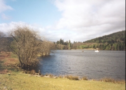
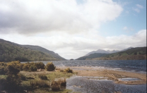
This was a very easy day in some nice walking weather, which made a change from the last few days. The path partly follows an old railway trackbed as it skirts the eastern bank of Loch Oich. This was a very pleasant stretch and because I knew I was not walking too far today, so I took a few breaks so that I could take rests and enjoy the very pleasant views.
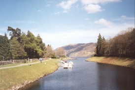
Fort Augustus is a very nice little town, and I m glad that I chose to end a short day's walking here. The whole town is based around the flight of five locks, with houses up both sides of the flight. At the bottom of the fight is a swing bridge, which is a great place to stand to see the locks rising behind you and the entrance to Loch Ness in front of you. This is consequently quite a captivating place to stand, especially when a boat passes through. Each lock takes about ten to fifteen minutes to clear, so a ship can get from the bottom to the top of the five locks at Fort Augustus in about an hour.
At the Aberchalder swing bridge I met the man who operates the bridge, and I had a quick chat with him about the bridge. It is in a beautiful situation, with Loch Oich in the background and the beautiful suspension bridge in front. The man had only been in his job for a few weeks, and he was getting some painting done before the busy season started.
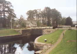
A little down the path I came into the Cullochy Locks, which are very pretty. The man who operates the locks was outside, and he invited me in for a cup of tea. I accepted, and spent a very pleasant half-hour chatting to him about the locks and the way that they are used. July is apparently the busiest month, with over 1,000 boats sometimes using the locks in that month some years. That does not seem like much until you realise that it means over 30 boats per day.
The whole of the canal is quite an impressive feat of engineering, especially when compared with narrow canals. The canal is widely attributed to Thomas Telford, but the original planning was done by William Jessop, who along with his son Josias Jessop was a very prolific canal builder. William Jessop is one of my favourite civil engineers, and therefore it is quite annoying to see books attribute the canal solely to Telford.
Today is seventy years to the day after the Kinder Mass Trespass occurred. Richard and Judy had an interview with the head of the Rambler's Association from Kinder Scout (which was actually in the lee of Mam Tor, which is not the same place!). This makes me think exactly how much we owe the trespassers - much has changed over the last 70 years in terms of land access - footpath laws have been passed and national parks and trails created.
I have decided that to reduce the punishment on my various aching limbs that I am going to give most of the food that I am carrying to the landlord and landlady of the B&B - I will most certainly not need such a large quantity of food for a while, so it makes no sense to carry it up hill and down dale. In particular I hope that this will reduce the stresses on my right knee which has been proving troublesome for a few days now.
It is difficult to know exactly what to do tomorrow - Invermoriston is only about eight miles away, which would make for a very short day, but Drumnadrochit is about 20, so I may ring up a B&B in Drumnadrochit and see if it is possible to get a lift from the youth hostel and one back again afterwards.
A suspension bridge is visible behind the swing bridge at Aberchalder. I had seen this last year when myself and Sam had driven over the bridge, but I got a far better view of it from the towpath. The suspension bridge is the second one here, being built in 1850 and was used until the swing bridge was completed in 1932. It is a very attractive bridge and I wish that it was still in use.
I spent a little time in the pub last night writing out the first tranche of postcards to be sent to friends and family. I find this to be a very time-consuming thing to do, as my hand writing is far from being the best in the world.
The weather forecast for tomorrow is for there to be some rain storms, and during the day after there should be some wintry showers in this area. The thought of this is fairly depressing, as the last thing that I want is to get wet once again. If the weather is bad then I may split the remaining walk into three days, with today being a very short walk. This is not ideal, but it is better than struggling for twenty miles through the rain.
Directions
This walk follows the newly-opened Great Glen Way north-eastwards, so navigation is very simple as the route is well waymarked. The walk starts off at the B&B at which I spent the previous night, which is beside the Scottish Youth Hostel in Laggan on the A82(T).
Turn left and head north-eastwards along the A82(T) for a short distance. When a wooden bridge becomes visible on the left cross it and follow a path that leads north-eastwards above the canal for about a kilometre until it merges back onto the A82(T) just before Laggan Swing Bridge.
Cross over the road and follow a road that enters a water park. The road continues behind the park and then climbs up to join an old railway line at an old station, the platform of which is covered in trees.
Turn left and follow the old trackbed north-eastwards along the southern bank of Loch Oich. In one or two place rock falls have fallen onto the trackbed and the path climbs these mounds. After about a mile the path leaves the trackbed and drops down a short distance to a path that runs along the Loch foreshore, with the trackbed in company above.
The path continues on along the foreshore, with some lovely views being available over Loch Oich. After a few miles near the northern end of the Loch it climbs steeply away from the foreshore before descending back to the railway trackbed on the other side. After the descent the Calder Burn is crossed by means of an old railway bridge and immediately on the other side a clapper gate leads off to the right. I found this gate impossible to negotiate with my pack on, and I had to take it off. Even then it was hard to get through, and it took me a few minutes of pushing and swearing to get my pack past it. The path then runs around the northern end of Loch Oich before turning to head northwards for the short distance to the A82(T) bridge over the Caledonian Canal at Bridge of Oich.
From here the path continues on the eastern side of the canal as far as Cullochy Lock along a good track. At Cullochy Lock the path crosses over to the other side and follows the western bank of the canal past Kytra Lock to the top of the flight of Locks at Fort Augustus. Here either side of the canal can be used to descend the short distance down to the swing bridge in the centre of the town.
Distances
| From | To | Distance (m) | Ascent (ft) | Descent (ft) |
|---|---|---|---|---|
| Laggan | Aberchalder | 5.0 | 335 | 371 |
| Aberchalder | Fort Augustus | 5.7 | 72 | 82 |
This makes a total distance of 10.7 miles, with 407 feet of ascent and 453 feet of descent.
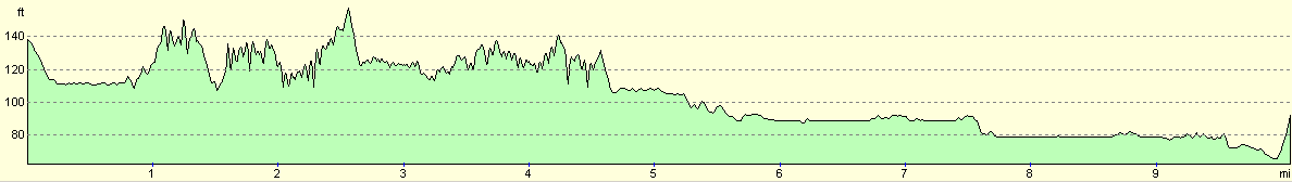
For more information on profiles, ascents and descents, see this page
Accommodation
I stayed at the Nia-Roo Lodge Guest House, Fort William Road, Fort Augustus, Inverness-Shire, PH32 4BQ. Telephone 01320 366783, and email jan@mansfield7.freeserve.co.uk. This was a nice bed and breakfast with very friendly proprietors who made me feel very welcome. It is only sixteen pounds per night, which is quite cheap for a nice and basic B&B.
Disclaimer
Please note that I take no responsibility for anything that may happen when following these directions. If you intend to follow this route, then please use the relevant maps and check the route out before you go out. As always when walking, use common sense and you should be fine.
If you find any information on any of these routes that is inaccurate, or you wish to add anything, then please email me.
All images on this site are © of the author. Any reproduction, retransmissions, or republication of all or part of any document found on this site is expressly prohibited, unless the author has explicitly granted its prior written consent to so reproduce, retransmit, or republish the material. All other rights reserved.
Although this site includes links providing convenient direct access to other Internet sites, I do not endorse, approve, certify or make warranties or representations as to the accuracy of the information on these sites.
And finally, enjoy your walking!
This walk was mentioned in the following routes:
| My sectional Land's End to John O'Groats walk |
Nearby walks
| # | Title | Walk length (miles) |
|---|---|---|
| 188 | Gairlochy to Laggan | 14.5 |
| 190 | Fort Augutus to Alltsigh | 11.4 |
| 666 | Alltbeithe to Torgyle Bridge | 19.1 |
|
|

|