Walk #666: Alltbeithe to Torgyle Bridge
 |
 |
|
General Data
| Date Walked | 08/05/2005 |
| County | Highlands |
| Start Location | Alltbeithe |
| End Location | Torgyle Bridge |
| Start time | 09.10 |
| End time | 18.05 |
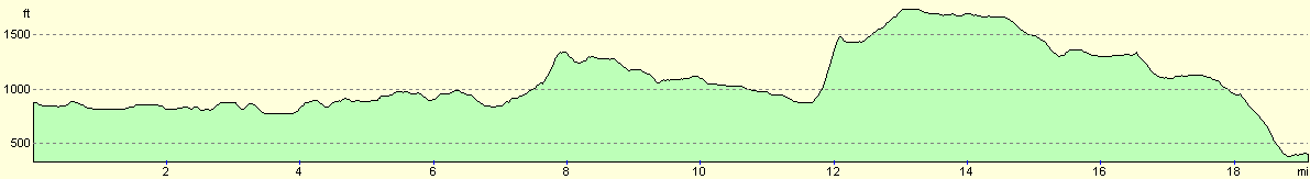
| Distance | 19.1 miles |
| Description | This was a surprisingly enjoyable walk, heading over the hills via Cougie. |
| Pack | Today I carried my 70-litre Craghoppers WildPlaces rucksack, filled with full camping gear. |
| Condition | My feet are really aching after this walk, which could be to do with the fact that my feet were soaked earlier on and there was a fair amount of walking on hard surfaces. Aside from that I am a little fatigued, but nothing unusual considering the distance I have walked. |
| Weather | The day started off wet with lots of heavy showers, including some sleet. After a couple of hours the rain showers slackened and there was more sunshine. This is the way it stayed for the rest of the day, aside from a couple of sleet showers towards the end of the day. It was slightly windy on the tops, enough to force me to put my balaclava on. |
| OS map | Landranger number 25 (Glen Carron & Glen Affric) and Landranger number 34 (Fort Augustus, Glen Albyn & Glen Roy) |
 |
 |
|
 |
 |
|
Map of the walk
Maps courtesy of Google Maps. Route for indicative purposes only, and may have been plotted after the walk. Please let me have comments on what you think of this new format. For a detailed table of timings for this walk, please see the table file.
 |
 |
|
Notes
I had a reasonable night's sleep, but it could have been so muc more restful if it had not been for the other two gent in the room snoring. I must remember to bring earplugs with me on future walks! I got up to find Steve Smith in the kitchen and rain lashing against the windows. I made myself a cup of tea whilst we chatted, but I did not want to start packing as that would have meant disturbing my two room mates who were still sound asleep. Just after eight Steve departed, and as my room was free I started slowly packing. My boots were slightly damp but nowhere near as wet as they had been yesterday evening, and all of my clothes except for my socks were dry. I chatted to Ellen, the warden, for a while and the Swiss girl who was staying gave me the Dan Brown book that she had finished reading. Extra weight, but also something to do in my tent at night
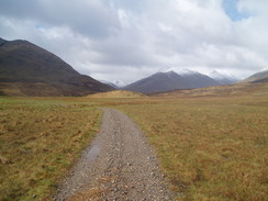
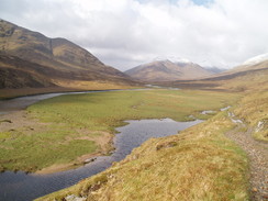
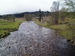
I was finally ready to leave at about ten past nine, and after I said goodbye to Ellen and the others I pulled myself out into the lashing rain, the penultimate challenger to leave (the last being one of my room mates shortly after me). I started along the track, thankful that the rain was coming from behind me, and started trying to avoid the wettest and boggiest section of the wet and boggy track. I made good time and soon overtook some other challengers, and after about an hour I found myself at Athnamulloch, where the track crosses the River Affric and becomes firmer. I strode along this section which rose and fell more than I had realised from the map, and I was soon overtaking John Burt on an uphill stretch. I was feeling fine and enjoying the views over Loch Affric to my left.
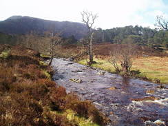
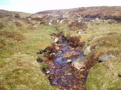
Eventually I reached the bridge near Loch Affric, and as it was raining I decided to forego my planned rest break and headed on up the path that led towards Cougie. Initially this runs beside the Allt Garbh and the going was very muddy underfoot, and on this section I got both of my feet wet from water, which was to be something that I would regret later on. As the path diverted away from the stream to head eastwards it became firmer underfoot, and at the top of the climb I was surprised to find that it became a firm and wondrously unboggy track. It was a superb walk with some god views, and I enjoyed every step as the track rose and fell, skirting past a loch that was much larger than it appeared on the map before plunging into some woodland. There has obviously been a great deal of clearance work her recently as the forest was not as widespread as depicted on the map, and indeed as I walked I could see logging work ongoing on the hillside to my right. From here the track became very firm, and I soon found myself looking down on Cougie, where many challengers were planning to spend the night.
,I dumped my rucksack off on a dry patch on a trailer, and relaxed for a few minutes, letting my sore feet dangle over the edge of the trailer. After ten minutes I hears noises from a nearby chalet, and so I went over to investigate. I was surprised to find that it was another TGO challenger, Craig Lumley, at 19 the youngest male challenger this year. I was sorry to hear that he had had to drop out with a pulled muscle, and as he walked around he winced slightly. We chatted for a while and I used the chalets facilities before saying goodbye and heading off. I gave myself a target of reaching the track near Beinn Bhan by five, and I soon fell behind schedule as I plodded uphill along a steep clearing. It was a bit of a puff, and I stopped a couple of times to catch my breath. I knew that I was not on the official path, and I was not surprised when I came across a deer fence blocking my route. Instead of climbing over it I started to follow it northeastwards for a few hundred yards until I reached a gate where the path entered left the woodland.
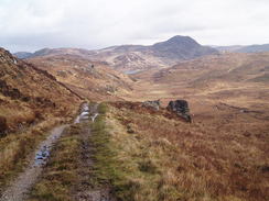
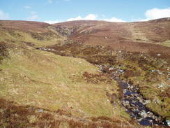
At the gate I met Peter Lumley, Craig's dad, and Bryan Crick, who were having a rest after the climb. We chatted for a while before starting to walk on along he path. They were a fair bit slower then me and when we reached Bealach Feith na Gamhna I said goodbye and strode on toward the end of the path and into open moorland. I was surprised to find that I had full mobile reception and I made a couple of calls as I walked. The going underfoot was boggy in places but nowhere near as bad as it had been yesterday, and it made for a really enjoyable walk in the afternoon sunshine. There were a few very boggy patches and some streams to be crossed, which always seemed to coincide with sleet or rain showers. Despite these I think that I made good time to the south of Beinn Bhan, after which I could see the power lines that marked the track clearly ahead. A small stream that had to be crossed delayed me slightly, but eventually I reached the track, a minute or two before my target time of five. This elated me and I kissed one of the galvanised legs of the pylon, before heading off down the track on weary feet.
After about a mile there was a stone square area on the left which looked as though it was a good possible camping site. I paced around the area looking for the best place to put my tent up, but nowhere was really sheltered from the wind. This was not too bothersome and in other circumstances I would have camped there, but I felt slightly unsettled and decided to plod on. I therefore continued down the track, and after a short distance I could see a couple of walkers ahead. I immediately thought that they were the men I had met earlier, and I wondered how they had got here so quickly. I soon caught them up and they turned out to be Gary Legg and Chris Kirk, two RAF engineers from Lincolnshire. I chatted to hem about where they were planning to camp, and they surprised me by replying that they had booked into a B&B at Torgyle Bridge.
They gave me the number of the B&B, and when I rang it I found that they had a double room available. I booked this, and with a little more spring in my step I continued on down the track. As it nears the A887 the track turns to head eastwards for a kilometre to the road, and instead of following this we decided to follow the power lines down. This was fairly steep but was an enjoyable walk, with a lovely stream running down a narrow gorge. There was a deer fence that prove easy to climb, and after this it was a quick plod down to the A887. As soon as I hit the tarmac my feet started aching a little more, and I was relieved that the B&B was only a couple of hundred yards away.
The landlady made us feel very welcome, and she offered to make us a meal at 19.15 and to do some washing for us. We staggered upstairs, and took it in turns to have showers before settling down for a superb three course meal {soup, chicken and a pudding) which was absolutely delicious. This was washed down by a couple of glasses of wine, which helped take the aching out of my feet and made me feel quite soporiphic. It was a superb evening, and the company was great, which led to me retiring to bed at about ten fifteen, far later than I normally go to bed on a walk.
Directions
This walk starts off at the Glen Carron youth hostel at Alltbeithe. Leave the hostel and turn left to start walking eastwards along the track that skirts the northern bank of the River Affric. Continue along the track for about three miles until the bridge over the river at Athnamulloch is reached. Cross the bridge, and once on the southern side continue along the track, which climbs up the hillside as it heads eastwards for another three miles before eventually descending to a bridge over the Allt Garbh near Affric Lodge.
Cross the bridge and immediately on the other side turn right along a footpath signposted for Cougie. The path skirts the eastern side of the stream (and does not cross it as shown on the map) as it climbs southwards. Before half a mile has been walked the path turns to the left to head eastwards away from the stream, and climbs steeply uphill before eventually meeting a track. Join this track and follow it eastwards; the going is easy as the good track rises and falls before passing a small loch and entering a patch of woodland. Continue along the track as it heads through the woodland for another couple of miles until the hamlet of Cougie is reached; accommodation is available here if necessary.
From Cougie I headed straight up the hillside southeastwards through a little clearing, although the official path heads further west of where I went. When I reached a deer fence I had to follow it southwestwards until I reached a stream, where there was a gate through the fence. Stay on this path as it continues southeastwards across Bealach Feith na Gamhna, after which it shortly ends. From here my route headed slightly north of southeastwards across the moorland, aiming for the southern edge of Beinn Bhan. The going was not too bad for moorland walking although boggy in places, and I was told that it was much worse further to the south near the forested area. Skirt under Beinn Bhan and the head southeastwards toward the obvious track that runs under the power lines. Once on the track turn right, and start following it as it heads southwards, after which it turns southeastwards and passes a track junction before entering an area of woodland. Shortly after this the track turns to the left to head away from the power lines; leave the track by turning right and following the power lines downhill to the A887. A stream and then a deer fence has to be crossed on the way, but these are both easy to follow. Once on the A887 turn right and follow the road for a couple of hundred yards; just after a phone box turn left along a private road. The B&B that I stayed it is the third house on the right.
Distances
| From | To | Distance (m) | Ascent (ft) | Descent (ft) |
|---|---|---|---|---|
| Alltbeithe | Cougie | 11.5 | 1496 | 1499 |
| Cougie | Torgyle Bridge | 7.6 | 1194 | 1663 |
This makes a total distance of 19.1 miles, with 2690 feet of ascent and 3162 feet of descent.
For more information on profiles, ascents and descents, see this page
Accommodation
I spent the night at Torgyle Lodge, Glenmoriston, Invrenesshire, Tel. 01320 340233 or mobile 07789 684259. This was an excellent B&B that cost me Ł25.00 for the night, including a load of washing and an three-course evening meal. Catherine Grange, the owner, made me feel extremely welcome and I enjoyed every minute that I spent there. I can highly recommend this B&B.
Disclaimer
Please note that I take no responsibility for anything that may happen when following these directions. If you intend to follow this route, then please use the relevant maps and check the route out before you go out. As always when walking, use common sense and you should be fine.
If you find any information on any of these routes that is inaccurate, or you wish to add anything, then please email me.
All images on this site are © of the author. Any reproduction, retransmissions, or republication of all or part of any document found on this site is expressly prohibited, unless the author has explicitly granted its prior written consent to so reproduce, retransmit, or republish the material. All other rights reserved.
Although this site includes links providing convenient direct access to other Internet sites, I do not endorse, approve, certify or make warranties or representations as to the accuracy of the information on these sites.
And finally, enjoy your walking!
This walk was mentioned in the following routes:
| The Great Outdoors Challenge 2005 |
Nearby walks
| # | Title | Walk length (miles) |
|---|---|---|
| 189 | Laggan to Fort Augustus | 10.7 |
| 190 | Fort Augutus to Alltsigh | 11.4 |
| 665 | Camas-Luinie to Alltbeithe | 15.6 |
|
|

|