Walk #667: Torgyle Bridge to Fort Augustus
 |
 |
|
General Data
| Date Walked | 09/05/2005 |
| County | Highlands |
| Start Location | Torgyle Bridge |
| End Location | Fort Augustus |
| Start time | 09.40 |
| End time | 13.09 |
| Distance | 7.1 miles |
| Description | This was a short walk, with one climb up a hillside before a long descent down to the charming village of Fort Augustus. |
| Pack | Today I carried my 70-litre Craghoppers WildPlaces rucksack, filled with full camping gear. |
| Condition | My feet are aching slightly, but this is a side effect of yesterday's walk. My legs and shoulders are not tired, and the only thing of any concern is my feet. |
| Weather | Aside from a few spits and spots of rain today was dry, which I am quite glad about. There was some sun and cloud and a little wind, but all in all it was a good day for walking. |
| OS map | Landranger number 34 (Fort Augustus, Glen Albyn & Glen Roy) |
 |
 |
|
 |
 |
|
Map of the walk
Maps courtesy of Google Maps. Route for indicative purposes only, and may have been plotted after the walk. Please let me have comments on what you think of this new format. For a detailed table of timings for this walk, please see the table file.
Notes
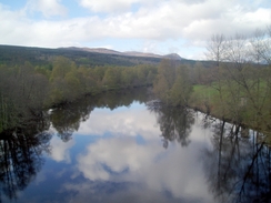
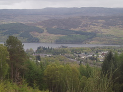
I had a really good night's sleep in a double bed that allowed me to sprawl out, and I woke up nicely rested and, with sun shining through the window, I felt good about the day. I went down for a superb filling breakfast provided by the landlady, and slowly I got ready for the walk, along with Gary and Chris, who were also preparing to go. As it was going to be a short day I was not in too much of a hurry to set off. When we eventually left we reached Torgyle Bridge itself, which spans a particularly picturesque stretch of the river. We stopped here so that a telephone call could be made (this being the only place where O2 calls can be made, whereas my mobile (which has Vodafone as a service provider) had reception from the moorland above Cougie). The initial stretch headed up a very easy forestry track, and I could keep up a good sped on this stretch along the well-surfaced track.
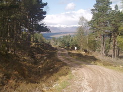
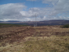
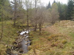
Under a kilometre from the A887 we turned left to had along another good forestry track, which headed uphill to the east, crossing the Allt Tarsuinn before eventually reaching the power lines that we had followed the night before. Here we left the good track and started following a rough track uphill, skirting the western set of power lines. The going got increasingly boggy as we headed uphill, and we took our time. The Allt Phocaichain ran through a lovely little gully, and this was followed by a boggy little plateau. Shortly after this as we approached some trees I could see some figures to me left, slowly angling towards me, and I soon discovered that they were walking along a forestry track. They turned out to be another couple of TGO'ers Sue Brooks and Avril Goddard, and the five of us started following the track on the descent down toward Fort Augustus.
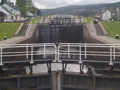
The track used to be part of Wade's military road network, and in places we could see old, decrepit stone ach ridges bypassed by the modern forestry track bridges. We had a lovely and varied chat as we descended, and it really made the journey through what would be normally boring forest fascinating. We easily navigated our way through Jenkins Park, and after going through a series of zigzags we reached the public road on the outskirts of Fort Augusts. Here we said goodbye to Sue and Avril, who stopped to use the public phone, and Gary, Chris and myself continued on into the centre of town. I in turn left them at the Tourist Information Office, and I walked on below the superb staircase locks to the Bothy Bar where is had a pint, not wanting to go directly to the B&B. In the bar I met another TGO walker, Nik from Nottingham, who had reached Fort Augustus the night before after a long walk in and was having a late lunch before walking on for the five miles to the bothy at Blackburn.
The rest of the afternoon was a good crack; I went to the B&B to drop my rucksack off before heading back into town to go to the Tourist Information office and do some shopping for the next few days. I then met up with Gary and Chris for another couple of pints and a chat before retiring to the B&B for a shower and to write my notes. This was then followed by more drinks and a good time, which really made an excellent day complete.
Directions
This walk starts off at the B&B at Torgyle Bridge. Leave the B&B and turn right to walk past the small caravan site to the A887 at the bridge over the River Moriston. Cross the bridge and follow the A887 on the other side as it curves to the right. When a forest track is reached on the left after a short distance turn left and follow the track as it climbs uphill, initially to the south as it passes under some power lines before curving to the right to head southwestwards. When a track junction is reached at NH304121 turn let and start following another forestry track as it heads east for about a mile towards two sets of power lines. Just before the first set is reached the track turns to the right to parallel them, uphill for hundred yards before curving to the left to pass underneath them.
Immediately after the first set of power lines turn right along a rough track that climbs uphill near the power lines. The track is fairly indistinct on the ground in places, but just follow the power lines until the Allt Phocaichain is reached, which runs through a small valley. Cross the stream and climb up the other side, before continuing on under the power lines as they angle towards some trees. As they near the trees a track is reached; join the track and follow it as it enters the woodland through a gate. Continue along the track as it slowly starts to descend downhill; it leaves the power lines behind and eventually reaches and crosses the Allt na Fearna. When the track curves sharply to the right at NH359098 continue straight on along a narrower and rougher path. This heads eastwards through Jenkins Park for about a kilometre before curving to the right and descending downhill along a series of zigzags. When the path ends at a track turn left and follow it for a short distance as it heads eastwards out of the woodland and onto a residential road. Continue in along the road past a phone box until a T-junction is reached and then turn right to head down to the A82(T). At the A82(T) turn right and follow the road around for a short distance until it reaches the tourist information office in Fort Augustus and, shortly afterwards, the river and flight of locks.
Distances
| From | To | Distance (m) | Ascent (ft) | Descent (ft) |
|---|---|---|---|---|
| Torgyle Bridge | Fort Augustus | 7.1 | 1079 | 1365 |
This makes a total distance of 7.1 miles, with 1079 feet of ascent and 1365 feet of descent.
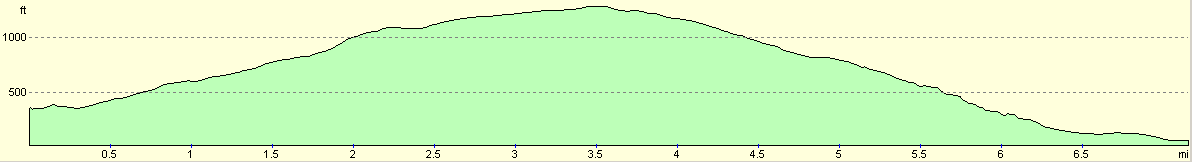
For more information on profiles, ascents and descents, see this page
Accommodation
I spent the night at Nia-Roo Lodge Guest House, Fort William Road, Fort Augustus, Inverness-Shire, PH32 4BQ. Telephone 01320 366783, and email jan@mansfield7.freeserve.co.uk. This B&B cost me Ł28 for the night.
Disclaimer
Please note that I take no responsibility for anything that may happen when following these directions. If you intend to follow this route, then please use the relevant maps and check the route out before you go out. As always when walking, use common sense and you should be fine.
If you find any information on any of these routes that is inaccurate, or you wish to add anything, then please email me.
All images on this site are © of the author. Any reproduction, retransmissions, or republication of all or part of any document found on this site is expressly prohibited, unless the author has explicitly granted its prior written consent to so reproduce, retransmit, or republish the material. All other rights reserved.
Although this site includes links providing convenient direct access to other Internet sites, I do not endorse, approve, certify or make warranties or representations as to the accuracy of the information on these sites.
And finally, enjoy your walking!
This walk was mentioned in the following routes:
| The Great Outdoors Challenge 2005 |
Nearby walks
| # | Title | Walk length (miles) |
|---|---|---|
| 189 | Laggan to Fort Augustus | 10.7 |
| 190 | Fort Augutus to Alltsigh | 11.4 |
| 666 | Alltbeithe to Torgyle Bridge | 19.1 |
|
|

|