Walk #665: Camas-Luinie to Alltbeithe
 |
 |
|
General Data
| Date Walked | 07/05/2005 |
| County | Highlands |
| Start Location | Camas-luinie |
| End Location | Alltbeithe |
| Start time | 09.32 |
| End time | 16.44 |
| Distance | 15.6 miles |
| Description | This was a mixed walk; a good track led me eastwards to Carnach, from where I headed south along the Anhainn Gaorsaic to the track that led onto the track that led to Alltbeithe. |
| Pack | Today I carried my 70-litre Craghoppers WildPlaces rucksack, filled with full camping gear. |
| Condition | I am tired but otherwise okay after this walk; it was hard going in places but it is quite rewarding to have finished. |
| Weather | The weather this morning was mixed; a couple of showers with significant periods of sunshine. This was followed in the afternoon by heavy rain, hail and even some wet snow. It did not feel particularly cold at any time, but the rain made that particular stretch of the walk very miserable. |
| OS map | Landranger number 25 (Glen Carron & Glen Affric) |
 |
 |
|
 |
 |
|
Map of the walk
Maps courtesy of Google Maps. Route for indicative purposes only, and may have been plotted after the walk. Please let me have comments on what you think of this new format. For a detailed table of timings for this walk, please see the table file.
 |
 |
|
Notes
I woke up this morning to rain lashing on the sloping window of my room. Before I even opened my eyes I knew that this did not bode well, and I lay in bed hoping that it would stop. By the time that I got up it appeared that my prayers had been answered and there was some sunshine in the valley, but also, surprisingly, snow quite low down on the hilltops. This instantly persuaded me that I was right not to take the high route, and as I ate my morning soup I felt quite relaxed, if only because of the salubrious surroundings. The others got up a fair bit later than me, and we ended up chatting for a while before John left shortly after nine. It did not take me long to pull all of my kit together and head off, initially to sunshine, which was a relief. The initial stretch of path was quite boggy, and at on stage it nipped into a wooded area that had a clapper gate that I could not get my pack through - I had to climb half over it in order to get to the other side.
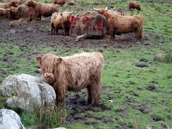
Once I reached the bridge at the new-looking bridge over the river Elchaig things improved as on the other side there was a good track. I was soon speeding along this and I soon overtook John, who was having a rest on a bridge abutment. I said hello and headed on, soon passing a herd of Highland Cattle who watched me warily. I also watched them warily, as a couple of years before a walked got gored to death by one. I got through safely (the young Highland Cattle looked lovely if slightly bedraggled) and headed on. I soon reached another couple who were also on the TGO - they were planning to walk up past loch Mullardoch and then on to Dumnadrochit.
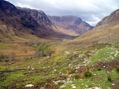
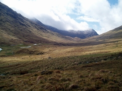
I felt pleased when I reached the house at Carnach, and as there was a lull in the drizzle I stopped for a rest. As soon as I had put my rucksack down the couple came past, and I chatted to them again before John came along. The four of us chatted before the couple went off, and John joined me to shelter behind the same boulder as me. As soon as he sat down it started to rain, and so we picked our packs up and started following the easy to follow pack uphill to the southeast. We then had a choice - we could either go directly up beside the Allt Coire Easaich, or alternatively take a longer route around. The path beside the river was visible and looked quite steep, and so I opted for the longer way round. It had stopped raining, and so John stopped for a rest and I plodded on along the track, which was boggy in places but very easy to follow
I reached the top earlier than I expected, but as it was raining again I decided to plod on without stopping for a rest. The track was initially easy to follow as it curved around to head southwestwards to rejoin the path to the north of Loch Lon Mhurchaidh. The track had other ideas, however, and skirted to the east of the lake by some distance. I was not bothered as it was heading south and I needed to be heading south, so I put my head down and strolled along. By this stage the weather was getting worse, and there was a long and annoying hailstorm, the hail coming down so hard that it stung the backs of my hands. The track soon became indistinct aand then ended, and I was forced to walk south along some very boggy ground - each foot squelched in water as I strode along, making for a very wet progress.
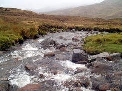
Eventually I came across the path, and this too was boggy although a better option than going cross-country. The path rose and fell, and large sections of it were flooded, and with every step water spurted up onto my waterproof trousers. At this point it started to sleet, and despite this I was still in quite high spirits. I gave myself the target of reaching the track at the end of Loch a' Bhealaich by half three, and this spurred me on and actually made the walk enjoyable to a certain extent. I powered on, but when I came to the allt Thuil Easaich I came unstuck; the stream was flowing very strongly and was very wide. I spent a few minutes for the best point to cross and then started across. I got nearly to the other bank using my poles to steady myself against the flow and this worked quite well, but as soon as I got my left foot onto the bank my trailing right foot went straight in. Fortunately I did not lose my balance and I did not tip in after it.
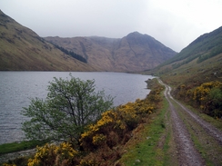
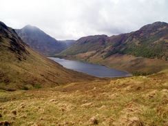
Fortunately that was the last difficult stretch and the rest of the way to the loch was far easier. I reached Loch Gaorsaic just as the sun came out for a short period, and the surface of the lake looked superb as water glinted off little wavelets. This spurred me on, and I was soon walking past Loch a' Bhealaich and looking for the path underfoot. I was well south of where it was due to start by the time that I found it, and even then it was fairly indistinct. It led me on, however, and soon I found the track that led from Bealach an Sgairne that led to the bothy. If I was hoping for firmer ground underfoot, however, I would be disappointed; the path, although distinct, was in places totally waterlogged and consequently was not the best walking.
The path did allow me to make better time, however, and I was soon back to my normal pace despite weary legs. As time went on the going became easier and although bogy, much more enjoyable if I could ever use that word in conjunction with the rain that as lashing down. As I approached the bothy I could see a couple of people in front of me, and I resolved to overtake the first of these as soon as possible (the first being too far away). I did this about half a mile from the hostel, and it turned out that he too was a first-time challenger.
When I got to the hostel I was relieved to find that there were quite a few beds free. I ended up sharing a room with the two men that I had raced to the end, and they also opted to stay rather than camp. I could easily have walked on further but I really fancied staying somewhere warm tonight, and good job - when I unpacked my rucksack my sleeping bad is wet through at one end, despite my having wrapped it in two plastic bags. This could be a significant problem, and I will see how well I can sleep in it tonight before I work out how well I will sleep in it tomorrow, when I have to camp. It was a good crack in the hostel tonight, and it certainly made me feel better about the rest of the walk as far as Fort Augustus. One of the people staying here tonight was on the train (the gent from near Marlborough), and he will be following a similar route to me, which is nice to know. Hopefully all my gear (except perhaps my boots) will be dry ready for another day's soaking. John came in at 19.15 - two and a half hours after me, and he looked absolutely cream crackered at the end. Ellen, the warden at the hostel, is very friendly, and I wonder how she copes with living in the hostel for most of the year - it is a three hour walk to the Cluanie Inn and the nearest glimpse of civilisation. A final note; John (who has completed ten challenges) said yesterday was the worst weather that he can remember having encountered on a challenge.
Directions
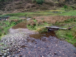
This walk starts off at the Faery Towers house in Camas-luinie. Go down the drive of the house and then turn right to walk along the road, where a track leads off to the right, with a little footbridge over a small stream. cross this bridge and at a gate turn left to start heading eastwards, roughly skirting the southern bank of the River Elchaig. After a little over a kilometre the path enters some woodland, and not far after it merge a farmstead is reached next to a bridge over the river. Cross this bridge, and when you meet a track on the other side turn right to head eastwards along the northern bank of the river.
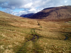
Follow this track for a little over four miles until a house is reached at Carnach. Here leave the track by turning right and hading down past the house to reach a little bridge over the river. Cross this, and once on the other side start following an obvious track uphill. After a short distance the track curves to the left to head slightly north of east along a pronounced valley; follow it as it does so, skirting a stream. the stream jinks to the right as it climbs and so does the path, heading southeastwards for a short distance, still climbing, before curving away to the right to head southwestwards. The track became indistinct but was still easy to follow as it headed on the eastern side of Loch lon Mhurchaidh, and from here a final climb took me up to the Allt Coire lochain.
From here simply follow the Abhainn Gaorsaic southwards; you may wish to stay a little higher to the east to avoid the boggiest ground. It is a hard walk in bad weather and is quite boggy. There is a path marked on the map from NH 027217, but this is indistinct on the ground; just keep on walking past the eastern shore of Loch a' Brealaich until a distinct path is reached near NH029206. At the path turn left and start following the path, which is reasonably distinct throughout, as it heads eastwards for about three and a half miles as it skirts the northern bank of the Allt Gleann Gniomhaidh, until the obvious Alltbeithe youth hostel in Glen Affric is reached.
Distances
| From | To | Distance (m) | Ascent (ft) | Descent (ft) |
|---|---|---|---|---|
| Camas-luinie | Carnach | 5.7 | 650 | 459 |
| Carnach | Loch a' Bhealaich | 6.3 | 1598 | 623 |
| Loch a' Bhealaich | Alltbeithe SYHA | 3.6 | 164 | 554 |
This makes a total distance of 15.6 miles, with 2412 feet of ascent and 1636 feet of descent.
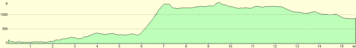
For more information on profiles, ascents and descents, see this page
Accommodation
I spent the night at the Glen Affric Scottish Youth Hostel, which cost me Ł11.00 for the night. This hostel is literally in the middle of nowhere, but it provides a good base for walking all the local mountains.
Disclaimer
Please note that I take no responsibility for anything that may happen when following these directions. If you intend to follow this route, then please use the relevant maps and check the route out before you go out. As always when walking, use common sense and you should be fine.
If you find any information on any of these routes that is inaccurate, or you wish to add anything, then please email me.
All images on this site are © of the author. Any reproduction, retransmissions, or republication of all or part of any document found on this site is expressly prohibited, unless the author has explicitly granted its prior written consent to so reproduce, retransmit, or republish the material. All other rights reserved.
Although this site includes links providing convenient direct access to other Internet sites, I do not endorse, approve, certify or make warranties or representations as to the accuracy of the information on these sites.
And finally, enjoy your walking!
This walk was mentioned in the following routes:
| The Great Outdoors Challenge 2005 |
Nearby walks
| # | Title | Walk length (miles) |
|---|---|---|
| 504 | Glenelg to Morvich | 18.0 |
| 505 | Morvich to Kyle of Lochalsh | 15.6 |
| 506 | Kyle of Lochalsh to Strathcarron | 19.7 |
|
|

|