Walk #664: Kyle of Lochalsh to Camas-luinie
 |
 |
|
General Data
| Date Walked | 06/05/2005 |
| County | Highlands |
| Start Location | Kyle of Lochalsh |
| End Location | Camas-luinie |
| Start time | 09.14 |
| End time | 16.14 |
| Distance | 15.6 miles |
| Description | This was a varied walk, with long road and path sections. |
| Pack | Today I carried my 70-litre Craghoppers WildPlaces rucksack, filled with full camping gear. |
| Condition | I am fairly tired after this walk, but aside from this and a few other little niggles (I may have a blister on a toe on my right foot) I am fine. |
| Weather | Today's weather was very mixed, with sunny periods interspersed with heavy showers. It was about thirteen degrees Celsius, and there was not much wind to chill me down when I was wet. |
| OS map | Landranger number 33 (Loch Alsh, Glen Shiel & Loch Hourn) |
 |
 |
|
 |
 |
|
Map of the walk
Maps courtesy of Google Maps. Route for indicative purposes only, and may have been plotted after the walk. Please let me have comments on what you think of this new format. For a detailed table of timings for this walk, please see the table file.
 |
 |
|
 |
Notes
I had a bit of Delhi belly last night, whether that was down to the long journey or nerves I do not know. This morning I woke up early to watch the election results on the TV, and went for breakfast at 07.30. I then went for a walk though Kyle, mainly to go to the shop to buy some last minute provisions, but also to walk down the slipway in order to dip my feet into the sea-hopefully in twelve days I will be doing the same on the east cost. I found walking around the car park upsetting as I had clear memories of staying there with Sam in Mervan. The weather was very mixed, with light drizzle interspersed with sunshine. it was also surprisingly chilly, and I decided that when I se off I would be wearing my coat as more showers are forecast. I am fairly low with memories of the coast walk and Sam, mixed with my stomach ache, but hopefully once I hit the road I shall be fine.
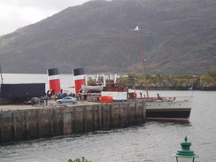
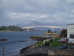
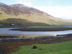
At the car park I got a good view over to the steamer Wavereley, which had just arrived, replacing the factory ship at the quay. It was a nice sight, and I watched it and the surrounding crowd for a few minutes before getting a passer-by to take my photo. I left Kyle feeling quite low, and as I walked out of the town northwards I could not help but to think back about the last time I had walked along the road, heading on to Stratchcarron via Plockton There were some good views of the sea and the Skye Bridge to be had, although as I passed through Badicaul it finally slipped out of sight. At Creag-dhubh I finally left the coast road and took a road that climbed uphill eastwards, reaching a height of 131 metres before descending past a couple of little Lochs to the attractive village of Balmacara Square.
I had been planning to follow the road on the short distance to the A87, but a sign pointed uphill, marking a path that led to Kirkton. This was visible on the map and so I decided to follow it instead of the long trudge along the road. This path proved to be a joy to walk along and far better than the road, and I managed to get some good views along Loch Alsh towards the Skye Bridge. Once past Reraig it got lower, but it was still a nice walk and I was annoyed when the path ended, unceremoniously dumping me onto the A87.For the first couple of miles there was a pavement, but once past Nostie it ended and I had to walk along the road for a mile until the Ardelve turning. Fortunately the road was not too busy and the tarmac surface allowed me to make good time.
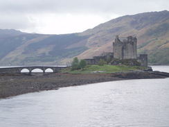
I had to sign in at the Loch Duich Hotel as the official start point of the TGO, and I had thought that this was actually in Dornie village itself. Fortunately just as I was approaching the bridge that carries the A87 over the loch I saw a sign for the hotel, and so I made a diversion to it in order to sign in. The bar was not open, so after using their toilet I headed off across the bridge, stopping frequently to photograph the fantastic Eilean Donan Castle. I was very tempted to go into the castle (which I did not visit on my Coastwalk either), but this was not a tourist trip and so I plodded on into the village.
I was in need of a rest and so instead of walking on I called in at the Clachan Bar in the village. This was a very friendly little place, and I spent an hour drinking a single pint of Red Cuillin and easting a baked potato with cheese and beans. I could easily have left after half an hour, but as I sat there was torrential rain outside (the morning had only had a few light showers), and so I decided to let the rain die down before heading out. Because of the rain I put my waterproof trousers and gaiters on, which proved to be a good decision later on. Eventually the rain abated and I started out heading northeastwards along a quiet minor road to Bundalloch.
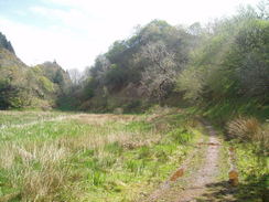
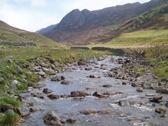
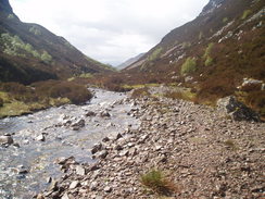
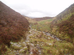
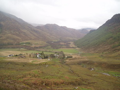
The going was easy until the road ended at a bridge over the River Glennan, where I joined a path that climbed slowly eastwards. Initially the path was easy to follow, but as it climbed it became less distinct. After a couple of kilometres I had to change almost continuously from one side of the river to the other, a task that became easier as I climbed and the river became smaller. It started raining and this became fierce for a time, but it was followed by sunshine and, just when my coat had dried, another shower. This turned out to be the weather pattern for the rest of the day - sunshine and heavy showers. The going was very boggy in places and the path indistinct, and although the climb was gradual I could certainly feel it in my legs and my feet (my socks were, by this time, wet). Eventually a pleasant seep climb took me to the very top, where I could see the spectacular Eas Ban waterfall of to my right and the little hamlet to Camas-luinie below.
I found it slightly difficult to find the path that led down to the village, and when I did find it the ground underfoot was very boggy. Eventually I found my way onto the road and I walked the short distance to the bunkhouse, where I had booked accommodation for the night. No-one was in, and so I sat down on the porch to shelter from the rain and studied my maps. Eventually a lady came and directed me to Faery Towers, a superb holiday cottage that they were letting me have for an incredibly low Ł7.50 for the night. I waited for another shower to finish before making my way to the house. And what a place it turned out to be - under floor heating, two washing machines, immaculate interior, nice, well-sprung beds - the place is heaven after a wet day's walking. Additionally they also have a phone, which means that I will not have to make the trudge up to the phone box in Killilan.
As I sat trying to work out which remote switched the television on (yes, the place even has satellite TV!) a gentleman called Ben came in, who turned out to be another walker who is climbing some of the local Munros. We had a good chat about walking and other matters, and he kindly offered to make me dinner, which I quickly accepted. He is from Peebles and has a car and bike with him, so he has far more provisions than I could ever have carried in. It made for a truly excellent evening. I also spent some time planning tomorrows walk after advice from the owner of the establishment (a very kind, generous man) I decided to alter my route slightly, going along the track to Carnach before crossing over to Gleann Gniomhaidh. Not only does this involve less climbing (which will be a boon if the weather is like today), but it will allow me to perhaps visit the Falls of Glomach if I feel like it.
Shortly after nine another couple of challengers came in. They had been camping further up the valley after a very strenuous and wet day's walking from Plockton (deer fences to be climbed, rivers to be forded etc). They had put their tents up at 19.30, but shortly afterwards a herd of Highland Cattle came sniffing around their tents. Not wanting to get tents ripped by the horns, they decided to break camp and came to stay in the flat. They were a nice couple of men, both individual TGO'ers who wee following the same route for the day.
Directions
This walk starts off at the Kyle of Lochalsh tourist information office. Leave the car park by the TI and head north towards a traffic light controlled crossroads. Cross over, and walk on past the Kyle Hotel and over a bridge over the railway line. Continue following this road as it winds through Kyle, eventually leaving the village and continuing northwards along the coast The road passes through Badicaul and Creag-dubh, where it starts to tame a more easterly course. At around NG 770298 a road junction is reached; turn right and follow this new road as it climbs slowly uphill eastwards, reaching a summit and passing Loch Palascaig and Loch lain Oig before descending down to Coilemore and Balmacara Square.
Cross a little bridge over a stream near some houses in Balmacara Square and continue on southwards for another couple of hundred yards until a track leads of to the left, signposted for Reraig and Kirkton. Take this track and follow it as it heads uphill, passing a high point and slowly descending down to Reraig. In Reraig it skirts past a house before continuing on eastwards for a little over a kilometre, eventually emerging onto the A87 at Kirkton. From here there is little alternative but to follow the A87 eastwards; fortunately there is a pavement for the first couple of miles. The road passes a junction with the A890 and heads on to the road junction in Nostie, where the pavement ends. Continue on for another mile until a road leads off to the right; follow this road as it head southeastwards through Ardelve, soon joining up with the A87 once again to cross Loch Long.
Once on the southern side of the bridge (and just before Eilean Donan Castle is reached) turn left along a surfaced footpath that leads down to the road that passes through Dornie. Continue along the road as it head out of the village along the eastern bank of Loch Long, passing through Lagg and Carndu before eventually reaching Bundalloch. The road eventually ends at a bridge over the River Glennan; cross this and immediately turn right to follow a track that heads eastwards along the northern bank of the river. The track soon ends and becomes a path that slowly climbs uphill. On the map it is shown as quickly crosing over to the southern bank of the river, but there was a mostly distinct path on the northern bank that I followed for a few kilometres. Eventually the path started crossing and re-crossing the river; initially this was not the easiest fording in the world but a I got higher and the river tamer it became easier. The going gets increasingly boggier and rougher until eventually the bealach is reached
From the bealach head straight eastwards down towards the houses visible in the valley below; as you descend ensure that you look at the spectacular waterfall off to the right. The path is indistinct in places, but just heads eastwards downhill, keeping to the north of the Allt Mor stream. The path bypasses a white house by a muddy, fenced path (which is the place where I stayed) and after this the road is hit. If you want the bunkhouse then turn left along the road; the bunkhouse is the last house on the left in the village.
Distances
| From | To | Distance (m) | Ascent (ft) | Descent (ft) |
|---|---|---|---|---|
| Kyle of Lochalsh | Dornie | 10.6 | 1470 | 1457 |
| Dornie | Camas-luinie | 5.0 | 938 | 869 |
This makes a total distance of 15.6 miles, with 2408 feet of ascent and 2326 feet of descent.
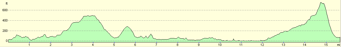
For more information on profiles, ascents and descents, see this page
Accommodation
I spent the night at the Tigh Iseabeal hostel, 1 Camusluinie, Killilan, Nr Kyle IV40 8EA, tel/fax: (01599) 588205. The hostel was actually full but the owner kindly let me stay with some other walkers in their superb holiday cottage for the night. This cost the same amount as the bunkhouse, Ł7.50.
Disclaimer
Please note that I take no responsibility for anything that may happen when following these directions. If you intend to follow this route, then please use the relevant maps and check the route out before you go out. As always when walking, use common sense and you should be fine.
If you find any information on any of these routes that is inaccurate, or you wish to add anything, then please email me.
All images on this site are © of the author. Any reproduction, retransmissions, or republication of all or part of any document found on this site is expressly prohibited, unless the author has explicitly granted its prior written consent to so reproduce, retransmit, or republish the material. All other rights reserved.
Although this site includes links providing convenient direct access to other Internet sites, I do not endorse, approve, certify or make warranties or representations as to the accuracy of the information on these sites.
And finally, enjoy your walking!
This walk was mentioned in the following routes:
| The Great Outdoors Challenge 2005 |
Nearby walks
| # | Title | Walk length (miles) |
|---|---|---|
| 503 | Kinloch Hourn to Glenelg | 19.9 |
| 504 | Glenelg to Morvich | 18.0 |
| 505 | Morvich to Kyle of Lochalsh | 15.6 |
|
|

|