Walk #23: The Limestone Way from Pomeroy to Castleton
General Data
| Date Walked | 23/05/1999 |
| County | Derbyshire |
| Start Location | Pomeroy |
| End Location | Castleton |
| Start time | 07.20 |
| End time | 13.30 |
| Distance | 14.0 miles |
| Description | This was the second day of the Limestone Way between Pomeroy and Castleton. |
| Pack | Today I carried full hiking kit, including tent, cooker and sleeping bag. |
| Condition | I feel okay after this walk. I took it easy as the early start meant that I would finish early. The biggest problem is a serious case of chaffing on the inside of my thighs that is more than a little painful. |
| OS map | Outdoor Leisure number 24 (The Peak District - White Peak Area) |
Map of the walk
Maps courtesy of Google Maps. Route for indicative purposes only, and may have been plotted after the walk. Please let me have comments on what you think of this new format. For a detailed table of timings for this walk, please see the table file.
Notes
; (23/05/1999)I am sitting in Castleton, waiting to be picked up to go home. Generally today was a far better day than yesterday, both health-wise and scenery-wise. Because I got a quite early start (07.15) I was able to take it fairly easy all day, and took a couple of unnecessary stops to waste time.
Healthwise I am reasonable. I have two small blisters on the usual culprits on my right foot, but nothing which have caused problems. The big problem are the inside of my thighs, which once again are bleeding. It is typical that when I was packing for this walk I left out the vaseline and the large strip plasters to save weight and bulk. In the future, if I even start to get soreness there, I must stop and treat the are liberally with vaseline. It is annoying to suffer a great deal after a hike for such a stupid reason.
The scenery on this stretch of the walk was much better than yesterday, especially the section between the A623 and Castleton.
Directions
For more details of this walk, see the book "Walking the Limestone Way", by R&E Haydock, B&D Allen, Scarthin Books, ISBN 0 907758 92 4. The only exception to this is the start of the walk, where I followed roads back to Flagg, where I had left the Limestone Way yesterday to make my way to the campsite.
Since 1994, the Limestone Way was extended from it's previous Matlock to Castleton route, to the new Rocester to Castleton alignment. The old route now forms the northern leg of this walk, and is still by far the most frequently walked. In the future I will walk the Rocester to Matlock section that I have yet to do, although knowing the area I actually believe that there are better alignments that can be walked, and that the route they chose for this section was constrained by having to reach Matlock.
Distances
| From | To | Distance (m) | Ascent (ft) | Descent (ft) |
|---|---|---|---|---|
| Pomeroy | Millers Dale | 5.9 | 518 | 1096 |
| Milers Dale | A623 | 4.8 | 1270 | 696 |
| A623 | Castleton car park | 3.3 | 341 | 965 |
This makes a total distance of 14.0 miles, with 2129 feet of ascent and 2757 feet of descent.
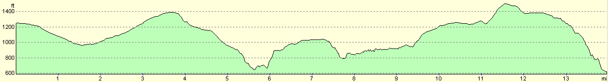
For more information on profiles, ascents and descents, see this page
Disclaimer
Please note that I take no responsibility for anything that may happen when following these directions. If you intend to follow this route, then please use the relevant maps and check the route out before you go out. As always when walking, use common sense and you should be fine.
If you find any information on any of these routes that is inaccurate, or you wish to add anything, then please email me.
All images on this site are © of the author. Any reproduction, retransmissions, or republication of all or part of any document found on this site is expressly prohibited, unless the author has explicitly granted its prior written consent to so reproduce, retransmit, or republish the material. All other rights reserved.
Although this site includes links providing convenient direct access to other Internet sites, I do not endorse, approve, certify or make warranties or representations as to the accuracy of the information on these sites.
And finally, enjoy your walking!
This walk was mentioned in the following routes:
| My sectional Land's End to John O'Groats walk |
Nearby walks
| # | Title | Walk length (miles) |
|---|---|---|
| 13 | Edale and Kinder Scout | 11.0 |
| 14 | Friden, Long Dale and Gratton Dale | 7.8 |
| 17 | Alport circular | 11.8 |
|
|

|