Walk #17: Alport circular
General Data
| Date Walked | 04/04/1999 |
| County | Derbyshire |
| Start Location | Alport |
| End Location | Alport |
| Start time | 09.15 |
| End time | 13.40 |
| Distance | 11.8 miles |
| Description | This was a pleasant walk through some of the dales in the White Peak. |
| Pack | Today I carried a full pack. |
| Condition | I feel fine after this walk. |
| Weather | It was slightly cloudy today. It was a bit cold due to the wind on the tops. |
| OS map | Outdoor Leisure number 24 (The Peak District - White Peak Area) |
Map of the walk
Maps courtesy of Google Maps. Route for indicative purposes only, and may have been plotted after the walk. Please let me have comments on what you think of this new format. For a detailed table of timings for this walk, please see the table file.
Notes
This was a very pleasant walk through the Derbyshire Dales, following the River Bradford and River Lathkill to Monyash. It is an area that I used to know well, and it felt great to be walking over the tops and through the dales once again.
Directions
This walk starts off in the pretty little village of Alport. Leave the village and take a footpath that follows the River Bradford southwestwards. After two-thirds of a mile at SK213639 a bridge is reached and the Limestone Way joined; continue on westwards along the southern bank of the river. At a footbridge below Youlgreave the footpath changes over onto the southern bank; continue on for another two-thirds of a mile. Shortly after the river curves to the right, cross the river and head westwards along a footpath that heads steeply uphill.
A road is met at the top of the hill; turn right along this road and follow it northwards. When the road curves sharply to the right continue straight on along a footpath that soon ends at another road. Turn left along this road and then continue along the Limestone Way as it heads straight on to the west, before curing to head northwards to another road.
Turn left along this road for a short distance, then at a junction turn right to continue following the Limestone Way northwestwards. The path skirts a farm at Calling Low before descending steeply into Cales Dale. The path climbs out of the dale westwards and then passes through One Ash Grange Farm. Continue along the Limestone Way as it heads across fields for a little over a mile and a half until a road is reached. This heads northwestwards for a short distance before curving to the right to head northwards into Monyash.
Follow the road northwards out of Monyash. At a road junction at SK150668 turn right along a track that leads into Bagshaw Dale. Half a mile later the path ends at the B5055 road. Turn left foe a few yards and then right to join another path that starts heading eastwards. Soon the banks on either side start to grow higher as Lathkill Dale is entered. The path runs along the northern bank of the formative river as it winds eastwards for four miles; at Conksbury Bridge turn right to cross the bridge, and then left along another footpath that heads southeastwards along the southern bank of the River Lathkill. After a mile Alport is reached, where this walk ends.
Distances
| From | To | Distance (m) | Ascent (ft) | Descent (ft) |
|---|---|---|---|---|
| Alport | Monyash | 6.1 | 1185 | 755 |
| Monyash | Alport | 5.7 | 679 | 1109 |
This makes a total distance of 11.8 miles, with 1864 feet of ascent and 1864 feet of descent.
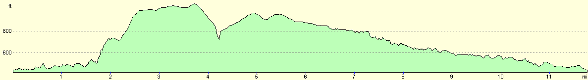
For more information on profiles, ascents and descents, see this page
Disclaimer
Please note that I take no responsibility for anything that may happen when following these directions. If you intend to follow this route, then please use the relevant maps and check the route out before you go out. As always when walking, use common sense and you should be fine.
If you find any information on any of these routes that is inaccurate, or you wish to add anything, then please email me.
All images on this site are © of the author. Any reproduction, retransmissions, or republication of all or part of any document found on this site is expressly prohibited, unless the author has explicitly granted its prior written consent to so reproduce, retransmit, or republish the material. All other rights reserved.
Although this site includes links providing convenient direct access to other Internet sites, I do not endorse, approve, certify or make warranties or representations as to the accuracy of the information on these sites.
And finally, enjoy your walking!
Nearby walks
| # | Title | Walk length (miles) |
|---|---|---|
| 2 | Waterbeach to Newmarket Road, Cambridge | 5.4 |
| 5 | A short walk around Waterbeach to Car Dyke | 3.0 |
| 6 | Waterbeach to Newmarket Road, Cambridge | 5.4 |
|
|

|