Walk #6: Waterbeach to Newmarket Road, Cambridge
General Data
| Date Walked | 18/01/1999 |
| County | Cambridgeshire |
| Start Location | Waterbeach |
| End Location | Newmarket road, Cambridge |
| Start time | 07.15 |
| End time | 08.41 |
| Distance | 5.4 miles |
| Description | This walk followed the western bank of the Cam as far as Baits Bite Lock, Milton before crossing over to the eastern bank. It was a nice, gentle walk, starting off in dark for the first ten minutes. I managed to jog the last couple of hundred yards to the office door, which felt like a nice way to finish the walk. |
| Pack | Heavy. All the ususal stuff plus the two barbells and fresh clothes. |
| Condition | Good. A hotspot has developed on the ball of my right foot. |
| Weather | The weather this morning was fine. There was not much wind, and although it was cold and frosty it was pleasant when the sun was shining on me. |
| OS map | Landranger number 154 (Cambridge & Newmarket, Saffron Walden) |
Map of the walk
Maps courtesy of Google Maps. Route for indicative purposes only, and may have been plotted after the walk. Please let me have comments on what you think of this new format. For a detailed table of timings for this walk, please see the table file.
Notes
Today looked as though it was going to be a nice day, and so I decided that it may be a nice idea to walk into walk. The most obvious route was to follow the River Cam southwards, and then cross the river at Baits Bite Lock and walk down into Fen Ditton, from where my workplace is just a ten minute walk away. I had walked this route before several times in the past, and so I was defintely going to be on home ground.
There is plenty of interest to see on the walk and it was far from a boring stroll. Just to the south of Waterbeach there is the place where the Roman Car Dyke (a canal that used natural watercourses and man-made cuts) met the Cam. This Dyke allowed Roman boars to go between the Cam and Lincoln, and traces of it can also be seen in Lincolnshire.
Further to the south, just beyond Baits Bite Lock, I came across a flotilla of rowing boats. Some were single sculls, whilst others were twin, four-man or eight-man boats. Each one of the eight-man boats was accompanied by a cyclist pedaling beside the boats as they rowed at speed down the river, yelling instructions at them. It all left me wondering how many of those rowers may be appearing for Cambridge in the boat race in future years.
Directions
(Note that these directions are from my flat in Bannold Road, Waterbeach; to walk it from the centre of the village remove 1/2 a mile, and from the railway station 3/4 of a mile).
Walk along Bannold Road towards Bottisham Lock and the River. Once the river has been reached, follow the western bank southwards until you reach the road near the railway station.
Cross over the road, and take a path in the field opposite which follows the road. This brings you out by the river just upstream of the road bridge.
Follow the river for a couple of miles. This is a very nice section of river and a joy to walk. Eventually you reach Bait Bite Lock, just south of a path leading to the village of Milton.
Cross over the bridge over the lock and follow the path past a house and then southwards through a wooded area. This wood then finished, and you cross a field and a stile before coming to a bridge under the A14. Pass under this, trying to ignore the noise of the traffic and cross a stile before angling across a field and onto a road.
Follow this road as it twists and turns through Ditton Green. At a junction near a cross, take a path straight ahead which leads eastwards through Fen Ditton.
When you reach a crossroads, turn right and follow Ditton Lane southwards for a little over half a mile. When this ends at a T-junction with Newmarket Road turn right; Acorn computers is immediately on the right. (note 2010: Acorn Computers is sadly no more; it became Element-14 and then part of Pace, before closing in 2002).
Distances
| From | To | Distance (m) | Ascent (ft) | Descent (ft) |
|---|---|---|---|---|
| Flat in waterbeach | Acorn Computers | 5.4 | 49 | 20 |
This makes a total distance of 5.4 miles, with 49 feet of ascent and 20 feet of descent.
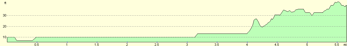
For more information on profiles, ascents and descents, see this page
Disclaimer
Please note that I take no responsibility for anything that may happen when following these directions. If you intend to follow this route, then please use the relevant maps and check the route out before you go out. As always when walking, use common sense and you should be fine.
If you find any information on any of these routes that is inaccurate, or you wish to add anything, then please email me.
All images on this site are © of the author. Any reproduction, retransmissions, or republication of all or part of any document found on this site is expressly prohibited, unless the author has explicitly granted its prior written consent to so reproduce, retransmit, or republish the material. All other rights reserved.
Although this site includes links providing convenient direct access to other Internet sites, I do not endorse, approve, certify or make warranties or representations as to the accuracy of the information on these sites.
And finally, enjoy your walking!
Nearby walks
| # | Title | Walk length (miles) |
|---|---|---|
| 2 | Waterbeach to Newmarket Road, Cambridge | 5.4 |
| 5 | A short walk around Waterbeach to Car Dyke | 3.0 |
| 7 | Waterbeach - Burwell - Swaffham - Waterbeach | 17.1 |
|
|

|