Walk #386: Pwllcrochan to Milford Haven
 |
 |
|
General Data
| Date Walked | 17/03/2003 |
| County | Dyfed |
| Start Location | Pwllcrochan |
| End Location | Milford Haven |
| Start time | 09.40 |
| End time | 17.02 |
| Distance | 16.9 miles |
| Description | I quite enjoyed this walk, and whilst some of it was dominated by an oil refinery, it also passed the imposing and much more attractive Pembroke castle. |
| Pack | Today I carried my 30-litre Karrimor HotRock rucksack, which was filled with my packed lunch, waterproof leggings, water bottle and a couple of spare shirts, together with the usual assortment of odds and ends. |
| Condition | The main problem I had today was tiredness, which really spoilt the day. Aside from this I had no other problems, although my feet ached a little by the end of the day. |
| Weather | This was by far the hottest day of the year so far, and the sun was shining all day with scarcely a cloud to be seen in the sky. The wind that has been annoying for the last few days was much less strong and much warmer. There was absolutely no sign of any rain, and all in all it was an absolutely beautiful day. |
| OS map | Landranger number 157 (St David's & Haverfordwest) |
 |
 |
|
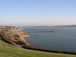 |
Map of the walk
Maps courtesy of Google Maps. Route for indicative purposes only, and may have been plotted after the walk. Please let me have comments on what you think of this new format. For a detailed table of timings for this walk, please see the table file.
Notes
Last night was yet another night when I did not get much sleep, and this is starting to really get to me. Although today generally went well, and it was quite an enjoyable day, I found the walk far harder than it should have been as my legs were stiff and my head hazy through tiredness. I really will have to get a batter night sleep tonight, or I will be in no fit state for another walk tomorrow. I do not have much of an idea about why I a finding it hard to sleep, but I am thinking a lot whilst I am awake. It is quite ironic that the most trouble I am having at the moment is lack of sleep, rather than a more obvious physical problem.
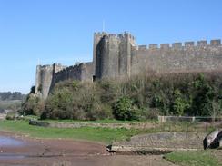
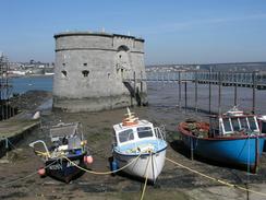
It was with leaden legs that I finally reached the massively impressive Pembroke Castle, which towers above the town. Most of the castle was built between 1190 and 1245 by William Marshal, and it's Great Keep is the best of its kind in Britain. The castle really is superb, and I wish that I could have taken more time to look around it, but I had to press on, as I had to meet Sam at Pembroke Dock. When I reached the village I met Sam at the Shipwrights Inn, a lovely little pub which is adjacent to the Gun Tower, a large stone tower in the river that is now a museum. Over 250 ships were built in the dockyard between 1814 and 1926, and the inn had a list of all of them on the wall. It even built five Royal Yachts, and was a pioneering shipyard, building the first steam-powered man of war, the Tartarus, as well as the first screw-powered ship for the Royal Navy. I enjoyed reading the list of the names, including unship like ones such as Gnat as well as more traditional names such as Conflict. After the docks shut the area became a flying boat base for nearly thirty years, including the Second World War.
The weather was so hot today that at lunchtime I had to take my coat off, and thus the afternoon was the first long period that I had walked without my coat on for five and a half months. Apparently Aberystwyth was the hottest place in Britain yesterday, and it reached a very un-spring like nineteen degrees Celsius! Hopefully the long stretch of sun that I have been benefiting from for a week now will continue, as it has been quite enjoyable and better than the rain that I had before.
I am very thankful for the Neyland Bridge. This was built between 1967 and 1975 and replaced a ferry that used to ply across the river. Near Saundersfoot a couple of days ago I met a couple who were walking their last section of the Pembrokeshire Coast Path, having started in the early seventies before the bridge was built. They have walked the entire estuary as far as Haverfordwest, and the bridge means that I thankfully do not need to do this because of the bridge - the estuary upstream of the bridge is quite long. The view from the bridge was quite lovely in both directions, with the upstream views being more attractive than those downstream, which were dominated by the refineries. The ferry service between Neyland and Pembroke Dock stopped when the bridge was opened in 1975, and thus ended a service that was started when Brunel made South Wales Railway terminus at Neyland. The railway closed during the Beeching cuts, and the ferry service thus did not last much longer.
Near the refinery I came across a footpath diversion order attached to a stile. I looked at it and worked out that the order had not yet come into force, so I continued on. I soon came across a work site, and I started chatting to a man who I was surprised to learn was an archaeologist. The refinery was getting ready to build two very large liquid gas storage tanks, and the foundations for these will go down one hundred feet into the ground, and this would totally destroy the archaeology of the old village of Newton (which had a connection with the famous astronomer Sir Isaac Newton). The archaeologists were thus excavating the area before the tanks were built, and they had already found the remnants of a Dovecote, only the eleventh known to exist in Pembrokeshire. The gentleman was extremely fascinating, and I enjoyed chatting to him - he was certainly very engrossing and knew his subject.
I have had two relatively short days now, and this has been a good thing, as I have been feeling under the weather. Tomorrow I would like to be able to get a bit further, and do a longer walk, perhaps getting past St Ann's Head (although this depends on the state of the tide when I reach the two estuaries that have tidal short cuts, and if the tide is low I should be able to get well past the headland).
Directions
| This walk follows the Pembrokeshire Coast Path, the route of which is detailed in the Ordnance Survey National Trail Guide 7, Pembrokeshire Coast Path (ISBN 1-85410-770-4). Unfortunately the route description is written in reverse to the direction that I am walking, but the 1:25,000 maps in the book are clear and the signs on the ground are very good. Please click on the image to the right to go to the Amazon page for this book. |
 |
Distances
| From | To | Distance (m) | Ascent (ft) | Descent (ft) |
|---|---|---|---|---|
| Pwllcrochan | Pembroke | 5.6 | 722 | 722 |
| Pemborke | Milford Haven | 11.3 | 1591 | 1617 |
This makes a total distance of 16.9 miles, with 2313 feet of ascent and 2339 feet of descent.
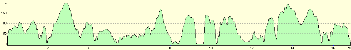
For more information on profiles, ascents and descents, see this page
Accommodation
We parked Mervan at the side of a street in Milford Haven, which had some nice views over the estuary to the jetties on the other side and the ships berthed at them.
Disclaimer
Please note that I take no responsibility for anything that may happen when following these directions. If you intend to follow this route, then please use the relevant maps and check the route out before you go out. As always when walking, use common sense and you should be fine.
If you find any information on any of these routes that is inaccurate, or you wish to add anything, then please email me.
All images on this site are © of the author. Any reproduction, retransmissions, or republication of all or part of any document found on this site is expressly prohibited, unless the author has explicitly granted its prior written consent to so reproduce, retransmit, or republish the material. All other rights reserved.
Although this site includes links providing convenient direct access to other Internet sites, I do not endorse, approve, certify or make warranties or representations as to the accuracy of the information on these sites.
And finally, enjoy your walking!
This walk was mentioned in the following routes:
| My walk around the coastline of Britain |
| Pembrokeshire Coast Path |
Nearby walks
| # | Title | Walk length (miles) |
|---|---|---|
| 384 | Lydstep to Castlemartin | 20.6 |
| 385 | Castlemartin to Pwllcrochan | 15.9 |
| 387 | Milford Haven to Wooltack | 19.7 |
|
|

|