Walk #384: Lydstep to Castlemartin
 |
 |
|
General Data
| Date Walked | 15/03/2003 |
| County | Dyfed |
| Start Location | Lydstep |
| End Location | Castlemartin |
| Start time | 08.30 |
| End time | 17.02 |
| Distance | 20.6 miles |
| Description | This was another superb walk, and one that I can recommend to anyone, as long as the section of path through the military tank range is open. |
| Pack | Today I carried my 30-litre Karrimor HotRock rucksack, which was filled with my packed lunch, waterproof leggings, water bottle and a couple of spare shirts, together with the usual assortment of odds and ends. |
| Condition | I feel absolutely fine after this walk, and have no significant problems to report. It is nice to know that I can do such a long and quite hard walk and not suffer from any problems. |
| Weather | The weather today was nice an sunny, with few clouds in the sky at any time. Unfortunately there was also a stiff breeze, and this was quite annoying when I was on the cliffs or exposed directly to the wind at a lower level. Yet again there was no sign of any rain, which is nice after the wet week that I had last week. |
| OS map | Landranger number 158 (Tenby & Pembroke) |
 |
 |
|
 |
 |
|
Map of the walk
Maps courtesy of Google Maps. Route for indicative purposes only, and may have been plotted after the walk. Please let me have comments on what you think of this new format. For a detailed table of timings for this walk, please see the table file.
 |
 |
|
 |
 |
|
Notes
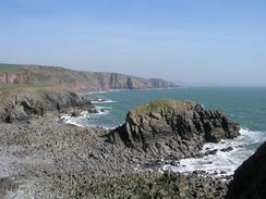
This was yet another stupendous day, and one that was very enjoyable. The scenery was without exception superb, and there was hardly a minute when there was not a great view of one sort or another. It was everything that I was expecting the Pembrokeshire Coast Path to be, and I can honestly say that the last couple of days have been better than I can remember any two consecutive days of the South West Coast Path as being, a fact that has surprised me considerably. Sam went into Pembroke to have her hair cut today, and she found out that the section of path through the Castlemartin tank ranges was open. This was very lucky, as this section of path was quite spectacular, and well worth seeing.
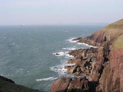
The first military range that I passed today was Manorbier Camp, which the path passes to the north of, missing out on the walk around the headland on which the camp is based. There were many interesting things to be seen through the fence, including various artillery pieces, a surface to air rocket launcher and two shipping containers that contain Petrel Rockets. Beside one of the buildings were some squaddies filling up canteens with water, obviously getting ready to go on exercise somewhere. I must admit that I find this sort of thing fascinating, and wish that I could have a look around such places. Yet again this is my love of big hardware showing through, as it did this evening when we passed the main camp for the Castlemartin artillery range at Merrion and saw a collection of tanks outside on display outside it.
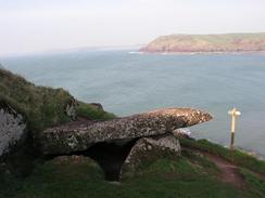
As I was walking past Priest's Nose (with its large vertical cracks ready to claim any unwary walker) I came across the King's Quoit. This is a series of stones that used to be a burial chamber, the first of this sort that I have seen of this walk and well worth seeing. It consists of a large slab set against the rock face, with a couple of smaller stones propping it up.
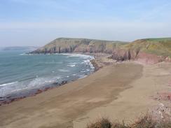
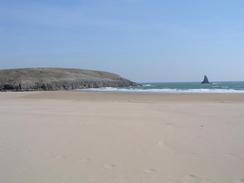
During my walk towards Broad Haven I had a phone call from BBC Radio Pembrokeshire so that I could record a radio interview. Unfortunately I could hardly hear a word she was saying due to the wind on the cliff top, so I asked her to call me back in five minutes, which would give me enough time to walk down to the beach at Broad Haven. This was a good idea in theory, but unfortunately it was let down buy the fact that at the beach I had no mobile reception. I jogged across the beach and up the cliffs on the other side hoping to regain reception, but as I got to the top I could see Mervan sitting in a car park. I had not been expecting to meet Sam, and as I approached I could see she was on the phone. As my mobile had been out of range the phone call had diverted to Sam's Orange phone, and fortunately Sam was still talking to the lady from the radio station when I arrived. Unfortunately I was both breathless and flustered when I arrived, and so the interview was nowhere near the best that I have ever done, but it should be being played sometime tomorrow, which will be nice.
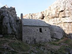
St Govan's Chapel was a lovely surprise. The chapel is built into the cliff face to the west of St Govan's Head, and is accessed down some steep stone steps. The chapel is quite an amazing building, built in a fissure in the rocks and dates back to at least the eleventh century, and was probably founded in the sixth century by St Govan. Legend has it that pirates pursued him to the edge of the cliff above the chapel, and miraculously a cleft in the rock opened where Govan could hide. He remained in the area until he died in 586, so it is likely the very earliest bits of the chapel date back to that time. The chapel is well worth the climb down to visit it, although it is very easy to pass it as it is not very well signed (I only found it because I was looking for it).
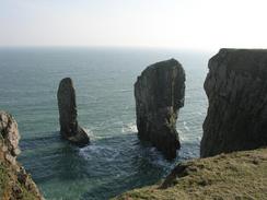
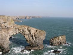
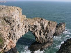
The walk westwards along the edge of the rifle range was superb, with some great views and a good track underfoot, which allowed me to speed along unhindered. The walk through the range ends at the superb scenery of the Elegug Stacks and the Green Bridge of Wales, the latter of which was one of the best views I have had on the entire walk. The bridge is a beautiful 80-foot high arch beside the cliff, with a stack alongside it, and it looked absolutely sublime in the bright sunshine. A couple of wooden platforms have been built to allow people to view them better, although I found the best views were available by getting nearer to the edge of the cliff. The Elegug Stacks were less impressive, mainly because I have seen many impressive sea stacks on this journey, and also because I had to view them into the sun, and could not find a position where I could photograph them away from it.
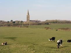
It was really nice to see some Old Red Sandstone cliffs again, the first that I can recall seeing since South Devon. The church here at St Petrox next to the campsite is made of the stone, and it looked absolutely superb as the sun set behind it - a fitting final view on this fantastic day. The church itself is quite Tardis-like, as it is surprisingly larger on the inside than it is on the outside. We have been told that the church is actually quite rare, as it is one of only two churches in the country that have carved heads (of a king and queen) on the outside of an east-west window.
Tomorrow I think that I will do a slightly shorter walk, and walk about sixteen miles instead of doing a longer walk and getting as far as Pembroke. I have had a couple of lovely days, and it will be nice to be able to take a shorter day and spend more time enjoying myself as I walk. The weather also promises to be slightly better, with less of the wind that annoyed me so much today. Annoyingly, however, I do not think that the cliffs will be as high, so the wind would not have been so annoying if it had been as strong.
 |
Directions
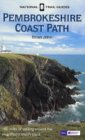
| This walk follows the Pembrokeshire Coast Path, the route of which is detailed in the Ordnance Survey National Trail Guide 7, Pembrokeshire Coast Path (ISBN 1-85410-770-4). Unfortunately the route description is written in reverse to the direction that I am walking, but the 1:25,000 maps in the book are clear and the signs on the ground are very good. Please click on the image to the right to go to the Amazon page for this book. |
 |
Distances
| From | To | Distance (m) | Ascent (ft) | Descent (ft) |
|---|---|---|---|---|
| Lydstep | Barafundle Bay | 9.6 | 2431 | 2621 |
| Barafundle Bay | Castlemartin | 11.0 | 1250 | 1083 |
This makes a total distance of 20.6 miles, with 3681 feet of ascent and 3704 feet of descent.

For more information on profiles, ascents and descents, see this page
Accommodation
We spent the night at the campsite at The Old Rectory, OS Field 1066, St Petrox, Pembrokeshire SA71 5EQ. They can be contacted on (01646) 683980. This site cost us seven pounds and twenty-five pence for the night, and was a nice enough site, placed right next door to the beautiful church of St Petrox.
Disclaimer
Please note that I take no responsibility for anything that may happen when following these directions. If you intend to follow this route, then please use the relevant maps and check the route out before you go out. As always when walking, use common sense and you should be fine.
If you find any information on any of these routes that is inaccurate, or you wish to add anything, then please email me.
All images on this site are © of the author. Any reproduction, retransmissions, or republication of all or part of any document found on this site is expressly prohibited, unless the author has explicitly granted its prior written consent to so reproduce, retransmit, or republish the material. All other rights reserved.
Although this site includes links providing convenient direct access to other Internet sites, I do not endorse, approve, certify or make warranties or representations as to the accuracy of the information on these sites.
And finally, enjoy your walking!
This walk was mentioned in the following routes:
| My walk around the coastline of Britain |
| Pembrokeshire Coast Path |
Nearby walks
| # | Title | Walk length (miles) |
|---|---|---|
| 383 | Pendine to Lydstep | 17.8 |
| 385 | Castlemartin to Pwllcrochan | 15.9 |
| 386 | Pwllcrochan to Milford Haven | 16.9 |
|
|

|