Walk #383: Pendine to Lydstep
 |
 |
|
General Data
| Date Walked | 14/03/2003 |
| County | Dyfed |
| Start Location | Pendine |
| End Location | Lydstep |
| Start time | 08.45 |
| End time | 16.40 |
| Distance | 17.8 miles |
| Description | This was an absolutely superb day, and probably he best since the end of the South West Coast Path. There was hardly a minute without a great view, and some of the villages I passed were beautiful. |
| Pack | Today I carried my 30-litre Karrimor HotRock rucksack, which was filled with my packed lunch, waterproof leggings, water bottle and a couple of spare shirts, together with the usual assortment of odds and ends. |
| Condition | I feel absolutely fine after this walk, and have no significant problems to report. My ankle ached again today, but nowhere near as much as yesterday, and not enough to worry me. |
| Weather | The weather today was absolutely superb, with bright sunshine all day and very few clouds in the sky. Unfortunately the wind was still quite strong, but not enough to really worry me. It felt as if it was quite hot in the mid afternoon, and at times I was quit glad of the wind to cool me down. |
| OS map | Landranger number 158 (Tenby & Pembroke) |
 |
 |
|
 |
 |
|
Map of the walk
Maps courtesy of Google Maps. Route for indicative purposes only, and may have been plotted after the walk. Please let me have comments on what you think of this new format. For a detailed table of timings for this walk, please see the table file.
 |
 |
|
 |
 |
|
Notes
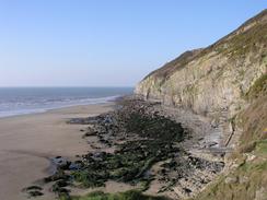
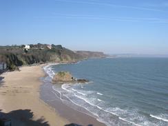
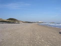
There are not enough superlatives to describe today. After a week that I have really not enjoyed much, today was great, superb, stunning, beautiful and enjoyable. It was also hard and steep in places, but the former points massively made up for the latter problems. The walk started well, with a steep walk up to Gilman and Ragwen Points giving some lovely views eastwards over Pendine Sands.
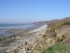
The first part of this walk was surprisingly hard, with steep climbs and descents to be made up Gilman Point, Ragwen Point and the hillside above Marros Sands. The views however, more than made up for the exertion spent, and in particular the early views eastwards over Pendine Sands were great. I could not walk around the headlands around Marros Sands (apparently it can be done at low tide), and this involved a good climb up and around Telpyn Point.
Wiseman's Bridge is a lovely area that I have visited before - an Auntie of mine has a cottage nearby. The area is so called because in 1943 Eisenhower, Churchill and Montgomery met there whilst preparations were being made for the Normandy landings. I stopped by the bridge over the stream and chatted to a couple for a few minutes, who were kind enough to give me some donations for the charity.
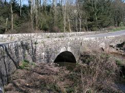
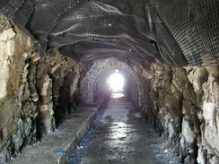
Between Wisemans Bridge and Saundersfoot the path follows the course of an old narrow gauge railway line, and this involved walking through three railway tunnels, the first of which was quite long. I enjoyed walking through these, the dark interiors having water dripping off the roof and onto the floor and making an eerie noise as it fell.
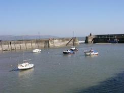
Tenby was absolutely wonderful, and I enjoyed walking through its streets and the views over the harbour, which my high-level route allowed me. The multi-coloured houses the flank the harbour looked superb in the sunshine, and the scene was, to my eyes at least, absolutely sublime. I met Sam by the harbour, and I ate my sandwiches (a very late lunch) whilst we waited for a report from a local newspaper to turn up. I then had the normal sort of interview and posed for some photographs before he left. We then had a little walk around the little headland around Castle Hill before ending up exactly where we had been (we could not descend down onto the South Beach from Castle Hill as the tide was too high). We therefore had to walk through the town before descending down onto the South Beach.
As has been the case over the last several days, military ranges intervened on my route. Today it was the Penally rifle range, and as I approached it along the South Beach from Tenby I could see red flags flying near a bunker on Giltar Point. This meant that I could not visit Giltar Point, which is a shame, and had to divert inland via Penally and the A4139 road. Fortunately there is a pavement beside the road and so it was not very dangerous, but it was nowhere near as nice as a walk around the point would have been. As I made my way back uphill along the western side of the range I had a quick chat to a solitary guard in a bunker who was well wrapped up against the piercing wind. It was a quick chat because neither of us could hear very well over the noise of the wind, and the bunker was a few metres within the range.
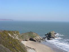
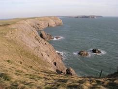
I had been considering walking as far as Manorbier, but by the time that I reached Tenby it was obvious that it was further than I wanted to do today. I therefore arranged with Sam to meet her at Lydstep, which is a little way inland. The last section of the walk from the range to Lydstep was quite spectacular, and in particular the views from the cliffs around Proud Giltar were well worth seeing, with Caldey Island looking superb on the skyline to the east.
I am unsure about how far I shall get tomorrow, as there are a couple of military area to negotiate, and the distance that I will have to walk is dependant on whether these ranges are open or closed. One in particular to the south of Castlemartin is very large, and I hope that this is open as it gives access to the spectacular Elegug Stacks and the natural arch called the Green Bridge of Wales. I will be a great shame if the range is closed and I cannot see these features.
 |
Directions
| This walk follows the Pembrokeshire Coast Path, the route of which is detailed in the Ordnance Survey National Trail Guide 7, Pembrokeshire Coast Path (ISBN 1-85410-770-4). Unfortunately the route description is written in reverse to the direction that I am walking, but the 1:25,000 maps in the book are clear and the signs on the ground are very good. Please click on the image to the right to go to the Amazon page for this book. |
 |
The exception to this is the start of the walk; the walk starts off at the car park in Pendine. Walk west towards the cliffs and then take a path that winds uphill to the top of Dolwen Point, before continuing on to the summit of Gilman Point. A steep descent follows to a small beach before ascending uphill along a zigzag path to Ragewn Point, before descending down onto the beach at Marros Sands. It is apparently possible at low tide to walk west from here along the beach and around the headland of Telpyn Point, but if the tide is high then when a house is reached on the right at Marros Mill head a little way past it before turning right to head uphill along a track. After a hairpin bend a footpath leads off to the left and heads westwards (not along the route marked on the map) which leads to Top Castle before descending down into a valley and ascending uphill again to Telpyn Point. From the point a path heads downhill, and I joined Amroth Beach right beneath the point, although if the tide is high you may have to join the road and walk the short distance along it to Amroth Castle, where the Pembrokeshire Coast Path begins.
Distances
| From | To | Distance (m) | Ascent (ft) | Descent (ft) |
|---|---|---|---|---|
| Pendine | Amroth | 6.0 | 1644 | 1637 |
| Amroth | Tenby | 6.7 | 1988 | 1978 |
| Tenby | Lydstep | 5.1 | 814 | 650 |
This makes a total distance of 17.8 miles, with 4446 feet of ascent and 4265 feet of descent.
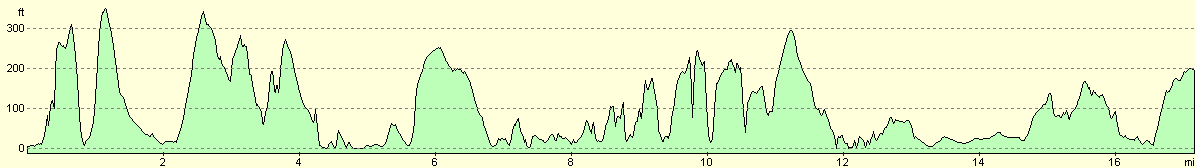
For more information on profiles, ascents and descents, see this page
Accommodation
We parked Mervan in the car park of the Lydstep Tavern in Lydstep, and the landlord of the Inn was kind enough to let us do this.
Disclaimer
Please note that I take no responsibility for anything that may happen when following these directions. If you intend to follow this route, then please use the relevant maps and check the route out before you go out. As always when walking, use common sense and you should be fine.
If you find any information on any of these routes that is inaccurate, or you wish to add anything, then please email me.
All images on this site are © of the author. Any reproduction, retransmissions, or republication of all or part of any document found on this site is expressly prohibited, unless the author has explicitly granted its prior written consent to so reproduce, retransmit, or republish the material. All other rights reserved.
Although this site includes links providing convenient direct access to other Internet sites, I do not endorse, approve, certify or make warranties or representations as to the accuracy of the information on these sites.
And finally, enjoy your walking!
This walk was mentioned in the following routes:
| My walk around the coastline of Britain |
| Pembrokeshire Coast Path |
Nearby walks
| # | Title | Walk length (miles) |
|---|---|---|
| 382 | Llansteffan to Pendine | 19.4 |
|
|

|