Walk #382:Llansteffan to Pendine
 |
 |
|
General Data
| Date Walked | 13/03/2003 |
| County | Dyfed |
| Start Location | Llansteffan |
| End Location | Pendine |
| Start time | 09.00 |
| End time | 17.31 |
| Distance | 19.4 miles |
| Description | This was a lovely walk on a sunny day, with some beautiful views available along the coast at times. |
| Pack | Today I carried my 30-litre Karrimor HotRock rucksack, which was filled with my packed lunch, waterproof leggings, water bottle and a couple of spare shirts, together with the usual assortment of odds and ends. |
| Condition | I had the first serious aches with my bad ankle for some time today, but after a thirty minute rest at Laugharne it had recovered and gave me no more bother. The worst thing is my stomach, which was unsettled and got worse as the day went on. It never got to the stage where I needed to find a toilet quickly, but it is very uncomfortable nonetheless. |
| Weather | The weather today was absolutely superb, with sunshine for most of the day and not much cloud. The wind that had been present for the last week had also died own, making it a lovely spring day. I can only hope that it can continue like this for as along as possible. |
| OS map | Landranger number 159 (Swansea & Gower, Carmarthen) and Landranger number 158 (Tenby & Pembroke) |
 |
 |
|
 |
 |
|
Map of the walk
Maps courtesy of Google Maps. Route for indicative purposes only, and may have been plotted after the walk. Please let me have comments on what you think of this new format. For a detailed table of timings for this walk, please see the table file.
Notes
After the travails of yesterday today was a much better day, and I ended up in a much better, and positive, mood. A walk such as this requires a great deal of mental effort, and yesterday had used up all my spare reserves. Fortunately today has recharged my reserves somewhat, and I feel much more confident, and generally higher in most ways. I am generally quite a positive person, and this means that it does not take much to make me cheerful, and today had bucket loads of things to make me positive.
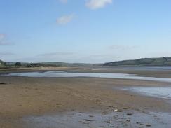
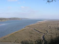
The first part of the walk from Llansteffan around Wharley Point was absolutely superb, with some great views available to the south, east and west, and this view alone made me feel better. It was well worth the climb, and its memories kept me going through the next section that was far from classic.
I met Sam by the church in St Clears, and we walked down the road to the Santa Clara pub. The door was shut and unlocked, so we went in to find the small bar absolutely deserted. We called out and looked around to no avail, and went out to the little shop next door to the pub to ask if it was open or not. As we did so the landlord came down the road with a loaf of bread, and we had a long chat to him as I supped my pint. the pub was small but lovely, and I enjoyed the break that this gave me from the walking. Later on as I was walking along the road to Pendine I received a text message on my mobile from Graham Harbord, who is currently in Edinburgh, and he commented on how nice it is to have long days, and I can only agree with him.
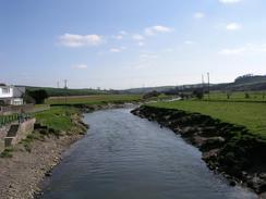
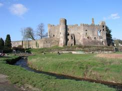
Laugharne was a very pleasant surprise. The whole village is very pretty, and I enjoyed stopping for a short while in the car park. This car park is in a beautiful situation, with a stream running in front of it and the ruins of the 12th Century castle towering above to the left. The castle is the most impressive ruin that I have seen for some time and is in a very spectacular setting, but unfortunately it was shut to the public and does not reopen until May. This is a great shame, as it is something that I would have loved to have a look around. I have passed many castes (or fortified manor houses) over the last couple of weeks, and the area must have been as unsettled as Northumberland, where I also came across many castles. Laugharne is also famous as a place where Dylan Thomas, the famous Welsh poet, lived. The boathouse in which he spent the last years of his life was under renovation and was therefore not open to the public, but I could look down on it from the footpath above it.
Unfortunately I could not walk along the long expanse of Pendine Sands, as the beach is used by the Ministry of Defence for research purposes. The beach is famous as a place where five world land speed record were broken in the 1920's, the last being a speed of 174.88 mph by Sir Malcolm Campbell in his car Bluebird in 1927. The beach is six miles long, and had near-ideal conditions for breaking such records, and I believe that it is also home to a military rocket-sled test range, where the model for the latest land speed record holder, Thrust 2, was tested at supersonic speeds. In the car park in Pendine where we spent the night there is a museum of speed, but this was also shut (all the exhibits were covered with dust sheets, so it is obviously shut until the season starts).
On the way to Pendine I passed a place called the Salt House, and this had two tracks outside it. Near one of them I notice a plaque on a stone which stated 'Salt House bypass, opened 1997', which made me laugh out loud. As I walked down the track towards the A4066 road I met the owner of the Salt House, who had heard about my walk on BBC Radio Wales a couple off weeks ago. We had a pleasant chat and he gave me a donation to the charity, which was kind of him.
Tomorrow I have a short but steep walk to reach Amroth, and the start (or officially the end) of the Pembrokeshire Coast Path. I am very much looking forward to this, as it promises to have some absolutely superb sections of path. This also means that the path will be much more strenuous than it has been recently, but this should not matter as the views will hopefully more than make up for the extra exertion.
Directions
This walk starts at the car park beside the beach in the village of Llansteffan. Walk south to leave the car park and walk along the beach for a few yards until some steps lead up to the right. Climb up these steps and then turn left along another footpath. This path skirts beneath the castle and descends down to near St Anthony's Well, from where a permissive path heads off around Wharley Point. There are some lovely views available from this path over the estuaries of the Gwendraeth, Towy and Taf. When the path ends at a road turn left to head northwestwards before taking the first road off to the left, which heads westwards downhill towards Pentowyn. Immediately after a quarry on the right turn right along a footpath that heads northwards, skirting the side of a hillside before reaching a road at Mwche.
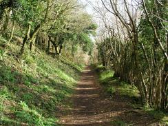
Join the road and turn left to head downhill, continuing past a road junction on the right until a T-junction is reached. Turn left to head towards a farm at Cwmcelyn, and when the road ends continue on through the farmyard. This next bit was quite difficult as there is no footpath for a couple of hundred yards, but continue on along the boggy flood plain until some woodland starts on the right. Climb up into the field beside the woodland and then turn left to join a broad path through the trees. This path emerges from the trees and continues on and ends at a road at Llandilo-aberowin. Turn left to walk through the farmyard and then turn right to head northwards. There is a footpath marked on the map for this section, but it is very indistinct on the ground, but keep the river floodplain in the left and head for the two sets of power lines. The path passes a standing stone next to the second set of power lines before the path crosses a boggy area and ends at a road.
At the road turn left and follow it as it heads uphill to the west until it ends at a T-junction. From this T-junction a footpath heads straight uphill ahead, but the stile to gain access to this was very overgrown and I had to find a gateway that gave access into the field. Head straight ahead uphill towards the trig point at the top of a hill (which is hidden behind a hedge). Continue on downhill slightly before turning to the right to head downhill, where a track is met that leads on to the farm at Pant-dwfn. From the farm head northwestwards along a footpath for a short distance downhill until another track is reached, which crosses over the Afon Dewi Fawr River and leads on to the A4066 road in St Clears.
If you wish to visit the church in the village then it is a short distance to the north. If not then turn left to walk south along the A4066 road for a few miles towards Laugharne. About a mile before the village is reached (at grid reference 298118) take a road that heads off to the left. This road passes a caravan site, and when it turns sharply to the right continue straight on downhill along a track until it reaches Delacorse. The path continues on across a couple of fields eastwards until it meets the estuary, and then follows the estuary around through some woodland. As it enters the village it passes Dylan Thomas's boatyard before meeting a road. Turn left to head downhill into the centre of the village, and descend downhill to the car park beneath the castle.
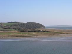
From the car park continue southwards along a track, and then before the track ends at a little water treatment plant turn right along a footpath that climbs uphill through an area of woodland. This path skirts the eastern flank of Sir John's Hill, which gives some lovely views over the River Taf and the sand dunes of the Pendine Burrows. The path eventually descends down to meet a track beside the Salt House, from where a footpath head along a track westwards. When this track ends turn right up a road for a short distance until it ends at the A4046 road. Turn left and walk westwards along the A4046 road for about four miles, until the village of Pendine is reached. The walk ends at a car park in the village next to the Museum of Speed.
Distances
| From | To | Distance (m) | Ascent (ft) | Descent (ft) |
|---|---|---|---|---|
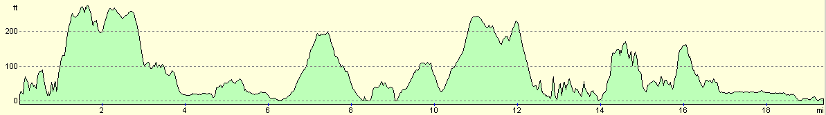
| Llansteffan | St Clears | 8.8 | 1070 | 1043 |
| St Clears | Laugharne | 5.1 | 764 | 787 |
| Laugharne | Pendine | 5.5 | 594 | 607 |
This makes a total distance of 19.4 miles, with 2428 feet of ascent and 2437 feet of descent.
For more information on profiles, ascents and descents, see this page
Accommodation
We spent the night in the car park in Pendine, which as usual had a sign prohibiting overnight parking. In accordance with our usual behaviour, we totally ignored the sign and parked in the car park. We have been doing this for some time, and I suppose that we will get caught out sometime. These car parks are incredibly useful, however, and in small places like this there is not much on-street parking.
Disclaimer
Please note that I take no responsibility for anything that may happen when following these directions. If you intend to follow this route, then please use the relevant maps and check the route out before you go out. As always when walking, use common sense and you should be fine.
If you find any information on any of these routes that is inaccurate, or you wish to add anything, then please email me.
All images on this site are © of the author. Any reproduction, retransmissions, or republication of all or part of any document found on this site is expressly prohibited, unless the author has explicitly granted its prior written consent to so reproduce, retransmit, or republish the material. All other rights reserved.
Although this site includes links providing convenient direct access to other Internet sites, I do not endorse, approve, certify or make warranties or representations as to the accuracy of the information on these sites.
And finally, enjoy your walking!
This walk was mentioned in the following routes:
| My walk around the coastline of Britain |
Nearby walks
| # | Title | Walk length (miles) |
|---|---|---|
| 380 | Pwll to Ferryside | 17.8 |
| 381 | Ferryside to Llansteffan | 18.6 |
|
|

|