Walk #380: Pwll to Ferryside
 |
 |
|
General Data
| Date Walked | 11/03/2003 |
| County | Dyfed |
| Start Location | Pwll |
| End Location | Ferryside |
| Start time | 08.25 |
| End time | 15.40 |
| Distance | 17.8 miles |
| Description | This was quite an enjoyable walk, following the coast as far as Pembrey Beach before heading inland around the Gwendraeth estuary. |
| Pack | Today I carried my 30-litre Karrimor HotRock rucksack, which was filled with my packed lunch, waterproof leggings, water bottle and a couple of spare shirts, together with the usual assortment of odds and ends. |
| Condition | I feel absolutely fine after this walk, and have no significant problems to report. I am still feeling slightly grotty in the mornings, but this soon goes after a couple of cups of coffee. |
| Weather | Today was by far the best day for some time, and was also my second dry day in a row. The forecast had said that there would be showers in the morning, but although the skies were quite black at times it never rained. As the day went on the clouds cleared, and late on there was some lovely sunshine, the first for about a week, and a very welcome sight. It was quite mild, and the winds that have been annoying me for the last few days also died down as the sun came out, making it an absolutely superb afternoon for walking. |
| OS map | Landranger number 159 (Swansea & Gower, Carmarthen) |
 |
 |
|
 |
 |
|
Map of the walk
Maps courtesy of Google Maps. Route for indicative purposes only, and may have been plotted after the walk. Please let me have comments on what you think of this new format. For a detailed table of timings for this walk, please see the table file.
Notes
I should really have enjoyed this walk, but unfortunately I found it rather lacklustre for some reason. The initial stretch was very easy to walk, as I was following the National Cycle Network route 4 all the way to the beach at Pembrey Burrows, and this was for the most part a firm surface underfoot.
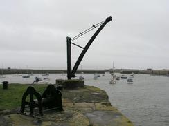
Burry Port looked nice this morning, and I enjoyed the walk around the harbour, which had recently been altered to keep a reservoir of water inside the harbour, even at low tides. I was interested to fins a well-worn stone plaque beside the harbour that commemorated the fact that Amelia Earhart landed her seaplane, Friendship, at the port after her record-breaking first flight across the Atlantic on June 18th 1928. She is more famous for disappearing on her attempt to fly around the world a few years later, but it is strange to think that such a momentous and famous journey ended at a spot like Burry Port, which can hardly be the first bit of land she came to on the flight.
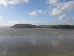
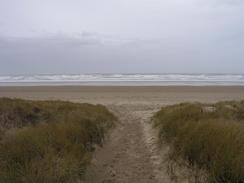
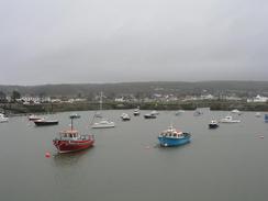
The walk along Pembrey Sands was very nice, and the walk along it was good, is a little bracing due to the stiff breeze. The beach was littered with cuttlefish bones, which seemed to be much more common that more normal shells. I must admit I got slightly lost in a highly stupid way. It had been my intention to walk along the beach until a track was met that leads northeastwards through the forest that lies directly behind the beach. I worked out the grid reference of where the path was, and when I got within a hundred metres of it I decided to climb up on top of the dunes to see if I could see it. I could not and I was concerned about missing it, so I rather stupidly decided to try and press on through the dunes towards the forest. This was easier said than done, as the area immediately behind the seaward dunes was covered in a tangled mesh of spiky bushes and brambles. I valiantly fought my way to the crest of another ridge of dunes, but from here on it was just too thick. I wandered up and down trying to find my way through, before giving up and going back to the beach. This was easier said than done, as the dunes were full of hollows that were invariably filed with the bushes, and this made for a rather slow and painful progress. When I reached the beach I turned right and walked along it for a short distance, and the gap through the dunes where the track reached the beach was clearly visible.
The military were making their presence felt over the Pembrey Sands. Occasionally as I approached there were some loud booms, and as I walked along the track through Pembrey Forest a plane was making a circuit overhead, diving down on one part of the circuit as if bombing something on the ground. Sometimes as the plane pulled away some other firecracker-style noises could be heard, as if guns were being let off or small munitions exploding. This went on all day, and as I walked to Ferryside along the northern edge of the estuary I got another good view of them enjoying themselves. Seeing this sort of thing always makes me curious about exactly what is going on, and it is slightly annoying that I will probably never know. Such vast areas of Britain are given over to the military, and so little knowledge is available of the details of what goes on inside them.
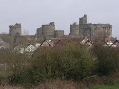
I had been warned by a local that Kidwelly was not a very nice place, so I was pleasantly surprised when I reached the village and found that it was not as bad as I feared. True, it was slightly depressed, as many towns in South Wales are, but it had lots of things to note in it, particularly the castle. I did not visit this, but I could get a good view of it from the floodplain as I walked away from the town. The first castle was of timber and earth construction, and was built in 1106 during the reign of Henry I. After many battles between the Normans and the Welsh it was rebuilt in stone in 1275, and was extended several times over the years, including the massive gatehouse that was completed in the early 1420's after the Owain Glyndwr uprisings. The church in the town was also quite nice, although it looked a little bleak even in the sunshine, the dark stone looking forbidding from a distance. Unfortunately I could not really get a good ankle from which I could take a photograph of it, which is a shame.
Since there was a campsite only a few miles away from where I finished today's walk, we decided it would be best if we stopped there for the night - we had been planning to stay at a campsite tomorrow night, but this one was fairly convenient. When we arrived there we got directed into an area, but whilst Sam was turning Mervan around the wheels got stuck in the mud. Much wailing and gnashing of teeth was then done, before we managed to get it out and manoeuvred into position for the night, a procedure that also involved a ladder, saw, and the amputation of a very large branch. Whilst all this was going on we got invited over to see a lamb that had been born a matter of a couple of minutes before, and it was a wonderful sight - the first time that I can remember seeing one quite so young. Hopefully we shall be able to get Mervan out of its current position in the morning without getting bogged down again - we are on a relatively hard surface, but this did not stop us getting bogged down earlier. The problem is that there has been so much rain over the last few days - the ground is totally saturated.
Although today was a significantly better day weather wise than has been the norm recently, I am left with a strange sense of despondency. I am unsure about why this is, but it may be something to do with the fact that I do not appear to be making much progress on my map - all these river estuaries are slowing me down. I managed to get another decent distance done today, but even this is starting to pall against when I think about how much remains to be done. Tomorrow I have another river estuary to walk around - another long one around the River Towy to Carmarthen and back again - and this is immediately followed by another estuary, this time the River Taf. The only good things about these estuaries are that they herald the start of the Pembrokeshire Coast Path, which starts a short distance west of the River Taf, and is a walk that I am very much looking forward to.
Directions
This walk starts off at Pwll, which is to the west of Llanelli. From the A484 road in Pwll head south across a playing field until a National Cycle Network cycle track is reached. Turn right along this cycle track and follow it as it heads westwards, soon crossing over onto the southern side of the railway line and reaching Burry Port. Walk around the harbour in Burry Port and then continue on westwards along the cycle track as it heads into Pembrey Burrows. When the cycle track turns to the right to head northeastwards continue straight on and onto Pembrey Beach.
Walk northwestwards along Pembrey Beach for a few miles until you reach grid reference 376025. Here a track leads inland to the northeast into Pembrey Forest, and after a mile it joins the cycle route once more. Follow the cycle route as it heads through Pembrey Forest and then skirts the southern edge of the mudflats beside the Gwendraeth Estuary and reaches the A484 road. Turn left and walk north along the A484 road for a few hundred yards. Immediately after crossing the Gwendraeth Fawr a roundabout is reached; turn left at this roundabout to head northwestwards along another road. After another couple of hundred yards a track leads off to the left immediately before the road goes over a railway bridge. Turn left down this track and follow it over another railway line, and on the other side of the bridge join a footpath that heads to a flood bank. When the flood bank is reached turn right to head northwestwards along it to a quay.
At the quay cross the remains of a canal and head eastwards along a track that becomes a road. It crosses a railway line on a level crossing by Kidwelly Station and continues on northeastwards into the centre of Kidwelly. When this road ends at a T-junction near the church turn left and follow another road that crosses over the Gwendraeth Fach. On the other side of the bridge turn left along a footpath that follows a flood bank westwards for about a kilometre before it ends at another road. At this road turn left and follow it for about four miles as it parallels the coast, slowly curving to the right as it does so to head northwards towards Ferryside. When the road ends at a T-junction turn to the left and follow another road that descends down to the riverside and continues on to Ferryside Station, where this walk ends.
Distances
| From | To | Distance (m) | Ascent (ft) | Descent (ft) |
|---|---|---|---|---|
| Pwll | Kidwelly | 13.0 | 338 | 358 |
| Kidwelly | Ferryside | 4.8 | 390 | 384 |
This makes a total distance of 17.8 miles, with 728 feet of ascent and 742 feet of descent.
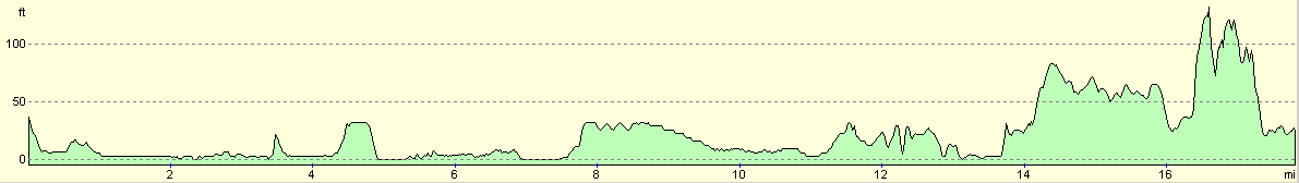
For more information on profiles, ascents and descents, see this page
Accommodation
We stayed at the campsite at Cilwg, Llandyfaelog, Kidwelly, Carmarthenshire SA17 5PY. They can be contacted by telephone at (01267) 267541. This site was fairly minimal and did not have a shower, but the owners were very friendly and helpful when we managed to get ourselves stuck.
Disclaimer
Please note that I take no responsibility for anything that may happen when following these directions. If you intend to follow this route, then please use the relevant maps and check the route out before you go out. As always when walking, use common sense and you should be fine.
If you find any information on any of these routes that is inaccurate, or you wish to add anything, then please email me.
All images on this site are © of the author. Any reproduction, retransmissions, or republication of all or part of any document found on this site is expressly prohibited, unless the author has explicitly granted its prior written consent to so reproduce, retransmit, or republish the material. All other rights reserved.
Although this site includes links providing convenient direct access to other Internet sites, I do not endorse, approve, certify or make warranties or representations as to the accuracy of the information on these sites.
And finally, enjoy your walking!
This walk was mentioned in the following routes:
| My walk around the coastline of Britain |
Nearby walks
| # | Title | Walk length (miles) |
|---|---|---|
| 378 | Port Eynon to Landimore | 18.6 |
| 379 | Landimore to Pwll | 19.7 |
| 381 | Ferryside to Llansteffan | 18.6 |
|
|

|