Walk #378: Port Eynon to Landimore
 |
 |
|
General Data
| Date Walked | 09/03/2003 |
| County | West Glamorgan |
| Start Location | Port Eynon |
| End Location | Landimore |
| Start time | 09.33 |
| End time | 17.06 |
| Distance | 18.6 miles |
| Description | This was a nice walk around the western edge of the Gower Peninsular, taking in Worms Head. |
| Pack | Today I carried my 30-litre Karrimor HotRock rucksack, which was filled with my packed lunch, waterproof leggings, water bottle and a couple of spare shirts, together with the usual assortment of odds and ends. |
| Condition | I feel absolutely fine after this walk, with no significant problems to report. The biggest problem is that I have a slightly sore throat, and early in the morning I a coughing slightly, although this clears up after a couple of hours. |
| Weather | Te morning was thankfully dry after the deluge of yesterday, although the wind was still present. There were even a few minutes of sunshine when the clouds parted enough, although this did not last long. In the afternoon rain clouds came in, and although this was light the wind made it feel quite nasty. Nonetheless it was nowhere near as bad as it was yesterday, and I ended the day in a far better mood, and far dryer. |
| OS map | Landranger number 159 (Swansea & Gower, Carmarthen) |
 |
 |
|
 |
 |
|
Map of the walk
Maps courtesy of Google Maps. Route for indicative purposes only, and may have been plotted after the walk. Please let me have comments on what you think of this new format. For a detailed table of timings for this walk, please see the table file.
 |
Notes
I had a very late start today, as I wanted to take advantage of the fact that we had mains power and I could use the computer. It had been my intention to get up at two to watch the Formula 1 grand prix from Australia, but I did not get to bed until nearly midnight as I was doing some script hacking. This was a shame, as it looks as though it was a good race for once, and the first race since 1999 that a Ferrari has not been on the podium. Because of going to bed late I also woke up late, and I found it quite hard to pull myself together wake up and get going.
After a very short day yesterday I am very glad that I managed to get a reasonable distance walked today. Even though I walked over nineteen miles, this still does not compensate for the rather miserable eleven miles that I did yesterday. Hopefully if I get another good distance tomorrow, I shall be back at an average sixteen miles a day over the last few days. I hate doing short days, as it really upsets my mental flow - something that is difficult to explain to anyone who is not walking long distance day after day. If I do a short day I get the feeling that I have to do longer distances over the next few days to compensate, and this puts pressure on me that I could do without.
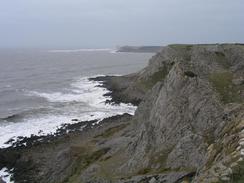
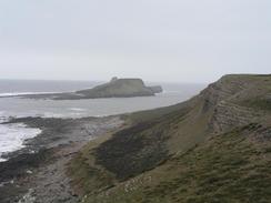
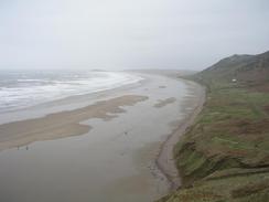
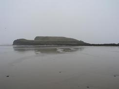
I have always heard great things about the Gower Peninsular, and whilst there were some nice views and scenery, it was nothing compared with the cream of the South West Coast Path. It could have been the weather, which even though it was not raining were reduced by the haze. The views over to Worms Head were not as spectacular as I had been led to believe, although some of the cliffs in the vicinity were lovely. On one of them were a series of rock climbers going up and down, and I stood and watched them progress for a couple of minutes, as I in turn was watched by some ponies that were beside me. In the sunshine this could have been an absolutely superb walk, but in today's weather it was just a mediocre one, which is a great shame. I will have to come back here sometime with someone who knows this area, so I can be shown the best parts - it could be that I missed them as I followed the coast.
As I was walking along the beach northwards from Rhossilli I got a phone call from Sam. As she had been moving off from the campsite she heard a noise and the clutch went soft. She stopped, and found a piece of metal in the foot well of the van. It looks as though part of the spring in the clutch assembly has broken, and although the van is still drivable it is something that needs to get fixed. This is only the second time that the van has let us down in any way, which is quite good considering the distance that we have driven in it over the last six months. Sam is going to drive into Llanelli in the morning to go and find a brake and cutch shop that can have a look at it.
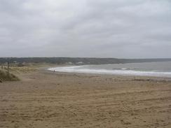
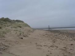
I walked further than I expected today, as when I planned the walk I had not intended to walk up as far as Whiteford Point, as there is only one footpath on and off the point. However when I reached the southern end of Broughton Bay I could see that the tide was out, so I decided to walk northeastwards along the beach past Prissen's and Hills Tor, before reaching the long expanse of Whiteford Sands to Whiteford Point. This lengthened the walk by two or three miles, and it would have been a very nice walk if it had not been for the rain that was falling as I walked along the beach. This rain prevented me from taking any photographs as I walked on this stretch, except for two or three short lulls in the rain.
I managed to burn the two smallest fingers on my right hand tonight in a rather stupid little incident. I was frying some mushrooms in a pan on the hob whilst Sam was beating eggs beside me, and because of the cramped cooking area I accidentally hit the handle and the pan slipped off the stove. I reacted instinctively and my right hand shot out to push the pan back onto the stove, and in the process I burnt the two fingers. Luckily the mushrooms did not spill onto the floor, and Sam finished off the omelettes whilst I sat with my hand submerged in a glass of water. I do not think that it is too bad, but it has made typing on my Psion (which is always difficult at the best of time) quite hard and slow.
Directions
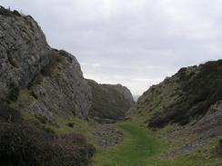
This walk starts off at the roundabout in Port Eynon, which is at the end of the A4118 road on the southern side of the Gower Peninsular. From the roundabout head south for a short distance to the beach, and then turn right along the beach towards the Youth Hostel. At the hostel turn right along a footpath that heads inland for a short distance before turning to the left and climbing up to the top of Port Eynon Point. Follow the footpath as it heads around the Point and passes Overton Mere and Overton Cliff. Shortly after this the footpath heads inland along a little valley, from where it heads inland before turning to the left and heading westwards along the coast. What follows is a lovely little walk that keeps away from the edge of the cliff, but descends and ascends several little valleys before eventually reaching the information centre at Kitchen Corner, next to Worms Head.
From Kitchen Corner follow a footpath that heads eastwards along the northern side of the peninsular into Rhossili. Immediately after a pub on the left take a footpath that heads steeply downhill to the left to reach the southern end of the beach. On the beach head north along it for a couple of miles until Spaniard Rocks are reached at the northern end. At the end of the beach turn right and head along a footpath that heads uphill through the dunes of Broughton Burrows before descending through a caravan park to Broughton Bay. If the tide is out then walk northeastwards along the beach past Prissen's Tor and Hills Tor, and then continue along Whiteford Sands until Whiteford Point is reached. At the point turn right and follow the beach eastwards for a short distance before turning right to head south past some woodland.
The footpath heads through the woodland before joining a track that crosses some boggy ground as it heads southwards. When the track reaches a wall on the left at The Groose then follow a footpath that runs southeastwards along the top of the wall at the edge of the marshland. After a few hundred metres follow the footpath as it turns to head southwards, where it joins a track that heads uphill and ends at a road in the village of Cheriton. Turn left along this road and follow it as it heads eastwards past the chapel and a church, before ascending and continuing on for about a mile to the village of Landimore, where this walk ends.
Distances
| From | To | Distance (m) | Ascent (ft) | Descent (ft) |
|---|---|---|---|---|
| Port Eynon | Worms Head | 6.4 | 1043 | 1073 |
| Worms Head | Landimore | 12.2 | 1293 | 1175 |
This makes a total distance of 18.6 miles, with 2336 feet of ascent and 2248 feet of descent.
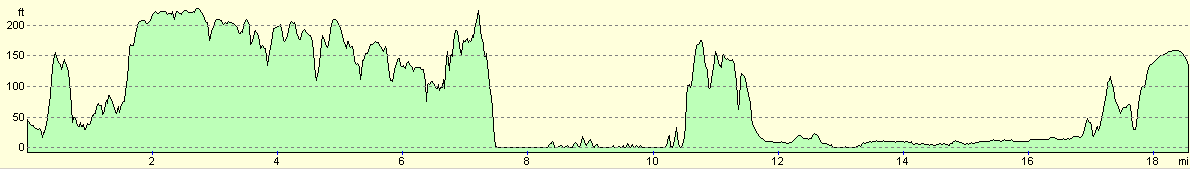
For more information on profiles, ascents and descents, see this page
Accommodation
We parked the van in a street in Landimore, which had no facilities but that did not really bother us that much.
Disclaimer
Please note that I take no responsibility for anything that may happen when following these directions. If you intend to follow this route, then please use the relevant maps and check the route out before you go out. As always when walking, use common sense and you should be fine.
If you find any information on any of these routes that is inaccurate, or you wish to add anything, then please email me.
All images on this site are © of the author. Any reproduction, retransmissions, or republication of all or part of any document found on this site is expressly prohibited, unless the author has explicitly granted its prior written consent to so reproduce, retransmit, or republish the material. All other rights reserved.
Although this site includes links providing convenient direct access to other Internet sites, I do not endorse, approve, certify or make warranties or representations as to the accuracy of the information on these sites.
And finally, enjoy your walking!
This walk was mentioned in the following routes:
| My walk around the coastline of Britain |
Nearby walks
| # | Title | Walk length (miles) |
|---|---|---|
| 377 | Caswell to Port Eynon | 11.3 |
| 379 | Landimore to Pwll | 19.7 |
| 380 | Pwll to Ferryside | 17.8 |
|
|

|