Walk #379: Landimore to Pwll
 |
 |
|
General Data
| Date Walked | 10/03/2003 |
| County | West Glamorgan, Dyfed |
| Start Location | Landimore |
| End Location | Pwll |
| Start time | 08.20 |
| End time | 16.10 |
| Distance | 19.7 miles |
| Description | This was a reasonable days walk, taking in the last, northwestern section of the Gower Peninsular and a long walk along a cycle path through Lanelli. |
| Pack | Today I carried my 30-litre Karrimor HotRock rucksack, which was filled with my packed lunch, waterproof leggings, water bottle and a couple of spare shirts, together with the usual assortment of odds and ends. |
| Condition | I feel absolutely fine after this walk, and have no significant problems to report. My feet are okay, which is slightly surprising considering I wore new boots for the first time. |
| Weather | For the first time in a few days today was dry, with no rain. There was no sign of the sun, however, and the cloud layers were quite thick for most of the day. The most annoying thing was the wind, which at times was quite strong and gusting, particularly when it blew straight into my face, making progress slow. |
| OS map | Landranger number 159 (Swansea & Gower, Carmarthen) |
 |
 |
|
 |
Map of the walk
Maps courtesy of Google Maps. Route for indicative purposes only, and may have been plotted after the walk. Please let me have comments on what you think of this new format. For a detailed table of timings for this walk, please see the table file.
Notes
During the course of today's walk I finished walking around the Gower Peninsular, and I must admit that I am to see the back of it. The weather has frankly been fairly awful, and this has meant that I have seen the area in far from the best light. Fortunately I can look forward to some more spectacular walking over the next couple of weeks around the Pembrokeshire Coast, although I still have a long way to walk to get there. It has been a shame that the Gower has been so disappointing, and I will have to visit here again at a time when the weather is better.
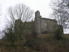
Early on in the walk I passes the curiously-named Weobley Castle, a 13th-century fortified manor house, like the ruined Candleston Castle that I passed last week. The castle is perched 150 feet above the Llanrhidian Marsh, and looked fantastic from my viewpoint almost immediately beneath it. Unfortunately that same viewpoint prevented me from getting a really good look at it, and trees partially obscured the view. I considered climbing up the hillside to get a better view of it, but it was early on in the walk and I was more concerned with pressing on and getting some miles under my belt.
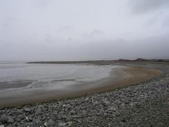
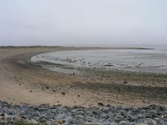
The latter half of the walk followed the National Cycle Network route 4, from Loughor to Pwll. Much of this was also a trail through the Millennium Coastal Park, which is a nice area that is slowly being landscaped. There is still much work remaining to be done, but it was still far better than an average road walk. The views across the estuary to the Gower were very nice, and I could easily make out the little light at Whiteford Point, which I walked past in the rain yesterday afternoon.
I nipped into the Wildfowl and Wetlands Centre to the south of Llanelli so that I could use their facilities. The Millennium Coastal Park passes right past the centre, and although I know very little about bird life I was quite impressed by what I saw of the centre, which has recently been extended with new flooded pits. I chatted to a very nice couple at the reception desk for ten minutes, and they seemed very interested in what I am doing. They told me lots about the centre, which is the Welsh centre of the Wildfowl and Wetlands Trust, which also have a centre at Welney, near where I live in Cambridgeshire.
I wore a pair of new boots today, my third pair of the trip so far. My second pair is not yet fully worn out, but they were quite damp after the last few days and so I decided to wear a new pair. Considering they were new my feet stood up well to them, with no blisters or hot spots on my feet resulting. My feet ached more than usual, but I was walking for a long way on tarmac or semi-made cycle paths, so this was hardly surprising. I changed out of my boots and into my trainers when I met Sam in Llanelli, and this helped me get a bit further without any problems.
We parked Mervan for the night within easy staggering distance of the Talbot Inn in Pwll. Children were happily playing in the street when we arrived, a nice sight in these times, and our arrival obviously attracted some comment. Over the next couple of hours until it got dark occasionally a child would come over and look as us through the window, making me feel rather like a caged animal in a zoo. As we walked out to the pub one young child asked us if it was our van and when I replied yes, he nodded and said that it was a good one. Such precocious knowledge in a child!
Tomorrow I should be able to get near to Carmarthen, following the National Cycle Network route 4 and local routes again to get there. Hopefully the weather (which has become rather an obsession of mine over the last few days) will be dry or, even better; I may be able to get a glimpse of that rare beastie called the sun!
Directions
This walk starts off at the crossroads in the little village of Landimore, on the northern side of the Gower peninsular. Leave the crossroads and walk northwards along a road towards the marshes beside the sea. After a short distance take a footpath heads off to the right and angles towards the base of the hills to the right. Te footpath meets the bottom of the hill and follows it as it passes under the delightfully named Weobley Castle and continues on for over a mile until it meets a track. The track continues on until it ends at a road in the village of Llanrhidian. At the junction continue on down another, tidal, road that heads northeastwards out of the village along the edge of the Llanrhidian marshes.
This road my be flooded on high tides; however it was dry enough when I walked along it, and I think it would have to be a very high tide to flood it. The road passes the hamlet of Wernffrwd as it parallels the B4295 road and enters Crofty. In this village follow the road northwards through it until the B4295 road is met. Turn left and follow the B4295 road, which has a pavement alongside it so it is safe enough. The road initially heads northeastwards into Pen-clawdd, where it turns to head eastwards for nearly three miles until a junction is reached on the left with Pont y cob road, where my route meets the National Cycle Network Route 4, which it shall follow until the end..
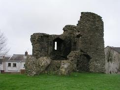
Turn left to head northwards up this road. It crosses a small bridge over a stream and then reaches one over a river near Island House. On the other side of this larger bridge follow the road around to the left before diving under a railway line and the A484 on a bridge. Follow the road on through Loughor until it ends at the A4240 road. Turn left along this road and follow it as it heads downhill past the remains of a castle until a roundabout is reached. At the roundabout continue straight on along a bridge over the River Loughor, and on until a roundabout is reached. Turn right at this roundabout down the B4297 road before taking a turning to the left that leads into a car park.
From this car park take the cycle path that heads out of it and heads or an elegant bridge over the A484 and the railway line. On the other side of the road the cycle path heads westwards beside the sea wall before it slowly turns to head inland. It passes under a footbridge that leads to part of the Wildfowl and Wetlands Centre before joining a surfaced road past the entrance to the centre. Just before the road passes under a et of power lines the cycle path leads off to the left, slowly turning to head southwestwards until it meets the estuary once again at Penrhyn Gwyn. The cycle path then turns to head northwestwards until it meets the B4304 road, which it follows northwards until a bridge is reached to the left. Cross this bridge into a car park, where the cycle path turns to the right and heads northwards along the edge of the estuary. It crosses over a railway line on a new bridge (which is actually more like a tunnel), and on the other side it turns to the left to follow the railway line westwards. After a mile a cricket ground is met on the right, and this can be crossed to reach the A484 road in Pwll. This walk ends at the Talbot Inn in Pwll, which is adjacent to the church in the village.
Distances
| From | To | Distance (m) | Ascent (ft) | Descent (ft) |
|---|---|---|---|---|
| Landimore | Bridge over River Loughor | 10.9 | 554 | 689 |
| Bridge over River Loughor | Pwll | 8.8 | 253 | 213 |
This makes a total distance of 19.7 miles, with 807 feet of ascent and 902 feet of descent.
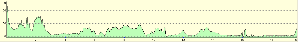
For more information on profiles, ascents and descents, see this page
Accommodation
We parked Mervan in a side street about a hundred yards up the road from the Talbot Inn in Pwll, which was convenient for the pub and other facilities. The only slight problem was that when we went into the pub we had a long chat about how the name of the town was pronounced, and after a few minutes neither of us had got it right!
Disclaimer
Please note that I take no responsibility for anything that may happen when following these directions. If you intend to follow this route, then please use the relevant maps and check the route out before you go out. As always when walking, use common sense and you should be fine.
If you find any information on any of these routes that is inaccurate, or you wish to add anything, then please email me.
All images on this site are © of the author. Any reproduction, retransmissions, or republication of all or part of any document found on this site is expressly prohibited, unless the author has explicitly granted its prior written consent to so reproduce, retransmit, or republish the material. All other rights reserved.
Although this site includes links providing convenient direct access to other Internet sites, I do not endorse, approve, certify or make warranties or representations as to the accuracy of the information on these sites.
And finally, enjoy your walking!
This walk was mentioned in the following routes:
| My walk around the coastline of Britain |
Nearby walks
| # | Title | Walk length (miles) |
|---|---|---|
| 376 | Port Talbot to Caswell | 16.0 |
| 377 | Caswell to Port Eynon | 11.3 |
| 378 | Port Eynon to Landimore | 18.6 |
|
|

|