Walk #376: Port Talbot to Caswell
 |
 |
|
General Data
| Date Walked | 07/03/2003 |
| County | West Glamorgan |
| Start Location | Port Talbot |
| End Location | Caswell |
| Start time | 08.30 |
| End time | 15.47 |
| Distance | 16.0 miles |
| Description | This was a fairly boring one, the only high point being the area around Mumbles Head, which was quite picturesque. The first half of the walk involved a really boring walk westwards into Swansea, and I am very glad that it is over. |
| Pack | Today I carried my 30-litre Karrimor HotRock rucksack, which was filled with my packed lunch, waterproof leggings, water bottle and a couple of spare shirts, together with the usual assortment of odds and ends. |
| Condition | I feel absolutely fine after this walk, and I have no significant problems to report. I have a curious abrasion mark on the top of the big toe on my right foot, yet I felt no rubbing on that part of my foot at all today. |
| Weather | Today's weather was very different to yesterdays, and in a negative way. I set off in some light rain with periods of heavy rain, and it remained that way until I reached the van in Swansea for lunch. The afternoon was better, with some sunny periods, but also some heavy showers and some very strong gusts of wind. It was fairly mild and I did not feel very cold, and I soon dried out after the showers in the afternoon due to the sun and wind. |
| OS map | Landranger number 170 (Vale of Glamorgan, Rhondda & Porthcawl) and Landranger number 159 (Swansea & Gower, Carmarthen) |
 |
 |
|
 |
 |
|
Map of the walk
Maps courtesy of Google Maps. Route for indicative purposes only, and may have been plotted after the walk. Please let me have comments on what you think of this new format. For a detailed table of timings for this walk, please see the table file.
 |
 |
|
Notes
The weather was the most noticeable item today, with the morning being characterised by continuous rain that was more than just annoying. To make matters worse, the route that I was following was along National Cycle Network 4, which is the nearest route to the sea and followed a busy dual carriageway. On more than once occasion lorries went past and threw up a great spray of water that covered me from head to toe, This was all utterly depressing, and there really was nothing to recommend this stretch of the walk at all. It is a classic example of where the weather totally dominates the walk, and removes any little pleasure that I may have got from the walk.
Fortunately the weather improved whilst I was in the van in Swansea Docks eating my lunch, and I set off again in the dry, which I was very thankful for. There were a couple of fierce showers that were accompanied with strong, gusting winds, but the same wind also ensured that once the showers were over I dried off quite quickly. Sam met me on the promenade and we walked for the last couple of miles to Mumbles Head together, escaping into a pub for a while to avoid one of the showers. The pub was empty when we entered, and we chatted to the barmaids for a few minutes until suddenly people came in and it became busier - it is not often that I feel like a trend setter (although more likely people were just coming into avoid the rain!)
I was not very impressed with Swansea, particularly when compared with Cardiff. I may not be being totally fair, as I did not walk through the city centre, and approach into the centre was along seven miles of boring dual carriageway that was hardly the most impressive way to reach the centre of any city. The area around the docks that I did see were pretty enough, but the rest of the city that I could see looked rather depressed. This is a shame, as it could be so nice, but it just looked anodyne and there was little of any distinction that I could see.
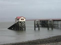
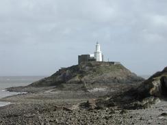
Mumbles Pier was quite nice, and it was not as overly commercialised as many of the piers that I have seen on the walk. That may be due to the fact that there is a 50 pence entry charge to get onto the pier; this may give the owners a reasonable income without having to fill it up with amusement arcades and slot machines. It also looked fairly well kept, and there was some quite nice architectural details on things like he handrails. The view over to the lighthouse on Mumbles Head was also quite nice, and if the rest of the Gower Peninsular is like this then I can see why it is famous.
I finished the walk at jut the right time, as a few minutes after I reached Mervan it started to rain, a heavy, persistent rain that was accompanied by some very strong gusts of wind. As it was I had managed to finish relatively dry, with only my trousers being damp, the strong wind having dried out my coat fairly quickly after the last shower. It was nice not to have to turn the interior of Mervan into a Chinese laundry, as we only had to dry my trousers out.
Tomorrow I shall be starting the walk around the Gower peninsular, which is a walk that I am very much looking forward to, and I can only hope that I have decent weather for it. Unfortunately the forecast is for more rain, and this means that this may be a less than enjoyable day.
Directions
This walk starts off by the A4241 road beside the Seaway Parade Industrial Estate, immediately to the south of the bridge over the M4 in Port Talbot. The first part of this walk into Swansea follows National Cycle Network Route 4, which is well marked on Ordnance Survey maps. Turn left to head over the M4 along Seaway Parade, and when a roundabout is reached on the other side turn left along the A48 road, which skirts to the north of a railway line and the M4. At a roundabout turn left along the A48 Eastwaood Bypass, which climbs to a bridge over the River Neath before descending to another roundabout. At this roundabout turn left down the A483 Fabian Way, which skirts to the south of the Swansea Bay golf course. The Ordnance Survey map shows the cycle route heading off to the north along the B4290 at the first roundabout; the signs on the ground continue along the A483.
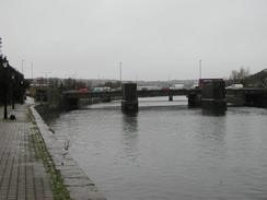
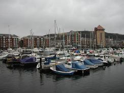
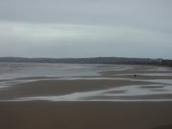
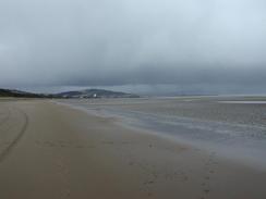
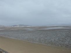
Walk westwards along the A483 Fabian Way for a few miles as it passes to the south of a works and then the north of the docks. When the road crosses the River Tawe turn left to walk along the western bank of the river until the old docks are reached. Walk down the northern side of the Tawe Basin before crossing a footbridge over the basin entrance and joining Trawler Road. Turn right down this road and follow it past the South Dock Marina until it approaches the coast, and then turn left to join the promenade along the coast. Follow the promenade westwards, or drop down to walk along the beach, for a few miles past Black Pill and The Mumbles until the pier at Mumbles Head is reached.
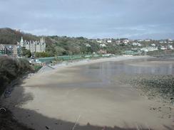
At the pier head back a few yards and take a road that heads uphill to join Mumbles Road. This road heads southwestwards past a large car park and The Tutt before curving around Limeslade Bay, where the road ends. A good footpath then heads on westwards along the coast, passing below Rams Tor before reaching Langland Bay. The path then continues on along Newton Cliff before eventually descending down the eastern side of Caswell Bay to meet Caswell Road, where this walk ends.
Distances
| From | To | Distance (m) | Ascent (ft) | Descent (ft) |
|---|---|---|---|---|
| Baglan | Swansea | 7.4 | 367 | 384 |
| Swansea | Caswell | 8.6 | 994 | 915 |
This makes a total distance of 16.0 miles, with 1361 feet of ascent and 1299 feet of descent.
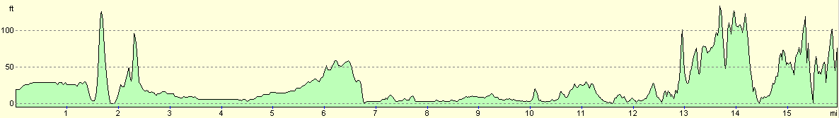
For more information on profiles, ascents and descents, see this page
Accommodation
We parked Mervan in the large car park at Mumbles Head, as the car park in Caswell was too exposed to the gusting wind, which was causing the van to rock. Unfortunately tonight there were many cars outside roaring up and down the car park, local youths using it as a racetrack. A couple of times cars screeched to a halt alarmingly near to the van, which caused Sam to wake up - she was concerned about how close they were. Eventually before eleven they all roared off, leaving us to the relaxing noise of the sea.
Disclaimer
Please note that I take no responsibility for anything that may happen when following these directions. If you intend to follow this route, then please use the relevant maps and check the route out before you go out. As always when walking, use common sense and you should be fine.
If you find any information on any of these routes that is inaccurate, or you wish to add anything, then please email me.
All images on this site are © of the author. Any reproduction, retransmissions, or republication of all or part of any document found on this site is expressly prohibited, unless the author has explicitly granted its prior written consent to so reproduce, retransmit, or republish the material. All other rights reserved.
Although this site includes links providing convenient direct access to other Internet sites, I do not endorse, approve, certify or make warranties or representations as to the accuracy of the information on these sites.
And finally, enjoy your walking!
This walk was mentioned in the following routes:
| My walk around the coastline of Britain |
Nearby walks
| # | Title | Walk length (miles) |
|---|---|---|
| 375 | Merthyr Mawr to Port Talbot | 21.3 |
| 377 | Caswell to Port Eynon | 11.3 |
| 379 | Landimore to Pwll | 19.7 |
|
|

|