Walk #339: Mevagissey to Portscatho
 |
 |
|
General Data
| Date Walked | 27/01/2003 |
| County | Cornwall |
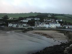
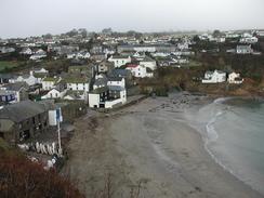
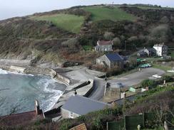
| Start Location | Mevagissey |
| End Location | Portscatho |
| Start time | 08.05 |
| End time | 16.25 |
| Distance | 18.3 miles |
| Description | This was a long and tiring walk along some superb coastal scenery. |
| Pack | Today I carried my 30-litre Karrimor HotRock rucksack, which was filled with my packed lunch, waterproof leggings, water bottle and a couple of spare shirts, together with the usual assortment of odds and ends. |
| Condition | I feel quite fatigued after this walk, but aside from this I had no real problems. My back was itching again and I had a few twinges from my bad ankle at times, but neither of these were major enough to come anywhere near spoiling the day. |
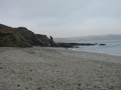
| Weather | The weather today was dominated by low cloud and mist, which hovered just above the cliffs and occasionally dipped below their tops. Despite this low cloud it never really rained, and the cloud was not dense enough for me to get wet from walking through it. It did spoil some of the views however, and also made photography difficult at times. The sun came through a few times in the afternoon, but there was always a sign of the low cloud that always made a reappearance, aided by the wind that was quite strong at times. |
| OS map | Landranger number 204 (Truro & Falmouth, Roseland Peninsula) |
 |
 |
|
 |
 |
|
Map of the walk
Maps courtesy of Google Maps. Route for indicative purposes only, and may have been plotted after the walk. Please let me have comments on what you think of this new format. For a detailed table of timings for this walk, please see the table file.
 |
 |
|
Notes
Part of my aim for today was to get a nice, long distance completed, as I have been rather slack around some of the estuaries in southern Devon and Cornwall and have been doing shorter distances. Now that the days are getting longer and it is not getting dark until five in the afternoon, I can afford to walk for longer, even on these rugged cliffs that I walk at a slower pace. Hopefully if I can get another few long days done it will push up my total mileage quicker, but this depends on the weather as much as anything else.
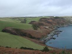
The first part of this walk was quite tough walking, with lots of little ascents and descents to be made. These were not as bad as yesterday's, however, and the last section of the walk southwestwards from Portloe was much flatter, which allowed me to have a little rest and get some speed up. There should have been some good views available on the first part of the walk, but unfortunately this was not the case due to mist at first and low cloud later on, which at times restricted visibility.
Mentally I found this walk tough. I do not know why, but for one of the few occasions on this trip so far I found myself questioning why I was putting myself through all this. Strangely enough this period of self-doubt occurred not at the end of the walk when I was not tired, but near the beginning. It also soon went, replaced with a strange sense of euphoria and joy. This is very strange, and I have no idea why I went through these strange and contradictory emotions.
Early on in today's walk I had a little slip, in a silly and rather unexpected manner. I was walking on a rather uncomplex but muddy section of path that sloped slightly down to my left when my right foot slipped down and I fell unceremoniously onto my right-hand side. I put my right hand out to stop myself, and I managed to place it on a patch of nettles - the first nettles that I can remember seeing for a long time. Fortunately I did not do myself any lasting harm, and I could continue with the walk as soon as I picked myself up. I did get the side and bottoms of trousers caked in mud, which during he day dried off and I spent a few minutes peeling this dried mud off whilst I ate lunch. Sometimes I find it amazing how I manage to waste time whilst I am on my lunch breaks!
Since we had been out for three nights without staying on a campsite we decided that it would be a good idea if we stayed in one tonight. Sam booked us into one, and it turned out hat it was right beside the South West Coast Path. Today's walk was due to be a long one and so I was unsure if I could manage the little extra distance to the campsite, but as I neared the scheduled end of the walk at Portscatho I phoned her up and told her not to meet me as I would walk to the site. This should save us a little time and hassle in the morning, as it means that I can set of without having to pack everything up in the van to drive the half mile into the village.
Sam shaved my head tonight, which was the first haircut that I have had since a few weeks before we set off on this trip. My hair was very long and was quite bushy, as my hair is totally unmanageable when it gets long, particularly when I wear hats during the day. I feel much better now that it has been cut as I feel like I am half presentable, but the downside is that my head will be colder whilst it is winter - I will have to wear my hat more. I am hoping that this will not be a case of Samson and Delilah, and that cutting off my hair has not sapped my strength!
Directions
| During this walk I followed the South West Coast Path, the route of which is detailed in the Ordnance Survey National Trail Guide 10, Falmouth to Exmouth (ISBN 1-854108-90-5). Unfortunately the route description is written in reverse to the direction that I am walking, but the 1:25,000 maps in the book are clear and the signs on the ground are very good. Also to be recommended is the South West Coast Path Association guidebook (ISBN 0-907055-04-4), which has less concise directions and no maps, but includes accommodation details and grades each section of the walk according to difficulty. They also publish reverse directions, which are suitable for walking in the direction that I walked the route. They have a website at www.swcp.org.uk, which is well worth a visit. | 
|
| 
| |
| |
| |
Distances
| From | To | Distance (m) | Ascent (ft) | Descent (ft) |
|---|---|---|---|---|
| Mevagissey | Gorran Haven | 3.0 | 741 | 725 |
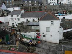
| Gorran Haven | Portloe | 8.0 | 2375 | 2336 |
| Portloe | Treloan Farm, Portscatho | 7.3 | 1608 | 1558 |
This makes a total distance of 18.3 miles, with 4724 feet of ascent and 4619 feet of descent.
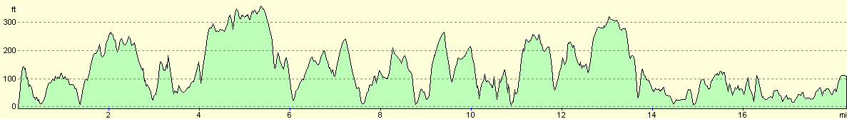
For more information on profiles, ascents and descents, see this page
Accommodation
We stayed at the campsite at Treloan Coastal Farm, which is just to the south of Portscatho. Their address is Treloan Coastal Farm Holidays, Treloan lane, Portscatho, The Roseland, Truro, Cornwall TR2 5EF, and they can be contacted on (01872) 580989 or by email at holidays@treloan.freeserve.co.uk. This site cost us ten pounds for the night including electricity hook-up, and was very handy for the South West Coast Path, as they have a dedicated path leading the couple of hundred yards frorm the campsite to the path.
Disclaimer
Please note that I take no responsibility for anything that may happen when following these directions. If you intend to follow this route, then please use the relevant maps and check the route out before you go out. As always when walking, use common sense and you should be fine.
If you find any information on any of these routes that is inaccurate, or you wish to add anything, then please email me.
All images on this site are © of the author. Any reproduction, retransmissions, or republication of all or part of any document found on this site is expressly prohibited, unless the author has explicitly granted its prior written consent to so reproduce, retransmit, or republish the material. All other rights reserved.
Although this site includes links providing convenient direct access to other Internet sites, I do not endorse, approve, certify or make warranties or representations as to the accuracy of the information on these sites.
And finally, enjoy your walking!
This walk was mentioned in the following routes:
| My walk around the coastline of Britain |
| South West Coast Path |
Nearby walks
| # | Title | Walk length (miles) |
|---|---|---|
| 338 | Fowey to Mevagissey | 16.9 |
| 340 | Portscatho to Ruan Lanihorne | 17.9 |
| 341 | Ruan Lanihorne to Feock | 16.6 |
|
|

|