Walk #340: Portscatho to Ruan Lanihorne
 |
 |
|
General Data
| Date Walked | 28/01/2003 |
| County | Cornwall |
| Start Location | Portscatho |
| End Location | Ruan Lanihorne |
| Start time | 08.28 |
| End time | 16.23 |
| Distance | 17.9 miles |
| Description | This was a fairly long walk, initially following the South West Coast Path and then following a combination of roads and footpaths around various tributaries of the Fal River. |
| Pack | Today I carried my 30-litre Karrimor HotRock rucksack, which was filled with my packed lunch, waterproof leggings, water bottle and a couple of spare shirts, together with the usual assortment of odds and ends. |
| Condition | I am more or less okay after today's walk. My bad ankle ached slightly at certain stages, but it never got to the stage where it was actually hurting. Aside from this I am fine, except for a slight fatigue. |
| Weather | Wind dominated today, and at times it was so windy that it was hard to make progress against it. Fortunately these periods were short lived and gusty, but when rain accompanied the wind it was really quite nasty. Out of the wind it was colder than it has been for the last few days, but in the wind it was very cold indeed. |
| OS map | Landranger number 204 (Truro & Falmouth, Roseland Peninsula) |
 |
 |
|
 |
 |
|
Map of the walk
Maps courtesy of Google Maps. Route for indicative purposes only, and may have been plotted after the walk. Please let me have comments on what you think of this new format. For a detailed table of timings for this walk, please see the table file.
Notes
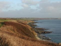
The wind was the most memorable part of today's walk. It was very strong all day, and whenever I emerged from the shelter of trees or onto the top if a hill I was exposed to the full fury of the wind. Unfortunately I did not take my walking poles with me this morning, and this was a shame, as these would have helped me cope with the wind more easily.
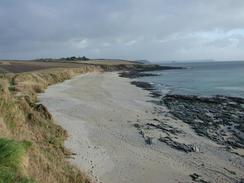
In some places I did not choose to walk the route nearest to the sea (or in most cases, river). Sometimes this was due to the fact that I did not realise that there was a closer route, and at others because I did not want to do long loops. I believe that I am justified in doing this as the main thing is for me to follow the coastline accurately and not the estuaries.
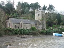
I visited a few churches on today's walk, and thankfully many of these were open. Again many of the saints commemorated by the church had unusual names - St Just, for instance. Many of these parish churches have the same sort of layout - a Nave and a south aisle, separated by an arcade of arches, with no north aisle.
I stopped off for a little rest at the Roseland Inn in Philleigh, which is a sixteenth century Inn. Just as I was passing the Inn a really wild patch of weather came over, and I decided to nip in and try to miss the worst of it. The Inn is exceedingly nice, and I sat by the warm fire as I chatted to the Brazilian barmaid as I supped a pint of Doom Bar, the local bitter.
I had been considering walking further than Ruan Lanihorne, but when I looked on the map it was obvious that there was not really any better place to be picked up on my route. There was also not much time left before it got dark, and so stopping there was probably the best thing.
Directions
| During this walk I followed the South West Coast Path, the route of which is detailed in the Ordnance Survey National Trail Guide 10, Falmouth to Exmouth (ISBN 1-854108-90-5). Unfortunately the route description is written in reverse to the direction that I am walking, but the 1:25,000 maps in the book are clear and the signs on the ground are very good. Also to be recommended is the South West Coast Path Association guidebook (ISBN 0-907055-04-4), which has less concise directions and no maps, but includes accommodation details and grades each section of the walk according to difficulty. They also publish reverse directions, which are suitable for walking in the direction that I walked the route. They have a website at www.swcp.org.uk, which is well worth a visit. | 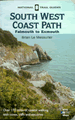
|
| 
| |
| |
| |
From Place Church follow the South west Coast Path through the graveyard until it hits a road. Here I turned to the right to follow the road for a couple of miles as far as Gerrans. However I later found out that you can follow the South west Coast Path to the ferry over to St Mawes, and then take a footpath through National Trust land around the peninsular, where it meets up with this road in Froe. This is a more coastal route, but I only discovered that the public could walk along it when I saw a sign in Froe!
The road enters Gerrans and passes the church before heading north out of the town. Immediately past the last house on the left take a footpath that leads off to the left, descending down to a stream before ascending up the other side and emerging onto a road opposite a cottage. Turn right down this road for a few yards to a triangular junction, at which you turn to the left. The road heads uphill, but after a few hundred yards take a footpath that leads off to the left. This footpath rises uphill slightly before descending through a couple of areas of scrub woodland before it reaches the A3078 road near Trethem Mill.
Turn left and follow the road as it heads uphill southwestwards into St Just In Roseland. Pass the junction with the B3289 road and then take the first road to the right, which heads downhill towards St Just Church. Enter the churchyard and follow a footpath past St Just's Well along the eastern side of a little creek. Follow the path northwards along the creek until it ends, and the footpath turns to the left to cross a stream. On the other side take a footpath that heads slightly to the right, signposted for Turnaware Point. The path heads up through an area of woodland before reaching a road.
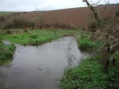
Turn right down this road and follow it northeastwards for a little under a kilometre until it reaches a T-junction with the B3289 road. Turn left down this road for about a mile, passing the farm at Penperth. When the road turns sharply to the left take a road that heads off to the right. This road heads through the little village of Phileigh before becoming more winding. Pass a road junction on the right and when a tarmac driveway is met to the left turn down it towards Trenestrall Farm. The tarmac ends and the track becomes unsurfaced as it passes between buildings, and when the track turns sharply to the left take another track that leads off to the right. This track becomes increasingly rougher as it descends downhill until at the bottom there was a flooded boggy area that I had to cross carefully.
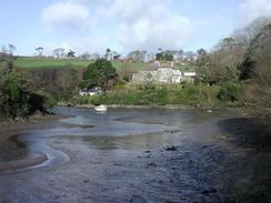
There is a little bridge over the actual stream, and on the other sided of this the track ascends uphill before ending at a bend in a road near the farm at Trelonk. Continue on down this road past the farm and follow it as it descend to a stream before ascending to another road junction. At this junction turn left and follow the road for a short distance to the church in Ruan Lanihorne, where this walk ends.
Distances
| From | To | Distance (m) | Ascent (ft) | Descent (ft) |
|---|---|---|---|---|
| Portscatho | Gerrans | 7.9 | 1332 | 1266 |
| Gerrans | Ruan Lanihorne | 10.0 | 1503 | 1634 |
This makes a total distance of 17.9 miles, with 2835 feet of ascent and 2900 feet of descent.
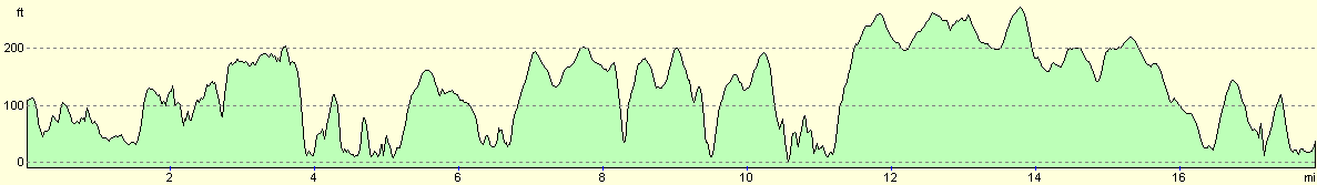
For more information on profiles, ascents and descents, see this page
Accommodation
There was not really anywhere practical to park in Ruan Lanihorne, so we drove three miles into Tregony and parked on the roadside in that town. The main street was very wide and sheltered us from the overnight gale force winds, and there was a nice pub and a shop close by. Unfortunately we parked right by the clock tower, so every hour during the night we had to pt up with a number of rings corresponding to the hour. This woke me several times during the night, and I felt like going out and doing something - anything - to stop those bells.
Disclaimer
Please note that I take no responsibility for anything that may happen when following these directions. If you intend to follow this route, then please use the relevant maps and check the route out before you go out. As always when walking, use common sense and you should be fine.
If you find any information on any of these routes that is inaccurate, or you wish to add anything, then please email me.
All images on this site are © of the author. Any reproduction, retransmissions, or republication of all or part of any document found on this site is expressly prohibited, unless the author has explicitly granted its prior written consent to so reproduce, retransmit, or republish the material. All other rights reserved.
Although this site includes links providing convenient direct access to other Internet sites, I do not endorse, approve, certify or make warranties or representations as to the accuracy of the information on these sites.
And finally, enjoy your walking!
This walk was mentioned in the following routes:
| My walk around the coastline of Britain |
| South West Coast Path |
Nearby walks
| # | Title | Walk length (miles) |
|---|---|---|
| 339 | Mevagissey to Portscatho | 18.3 |
| 341 | Ruan Lanihorne to Feock | 16.6 |
| 342 | Feock to Falmouth | 15.4 |
|
|

|