Walk #341: Ruan Lanihorne to Feock
 |
 |
|
General Data
| Date Walked | 29/01/2003 |
| County | Cornwall |
| Start Location | Ruan Lanihorne |
| End Location | Feock |
| Start time | 08.46 |
| End time | 17.08 |
| Distance | 16.6 miles |
| Description | This was an eventful and frankly upsetting day's walk, and one that I shall remember for a long time for the wrong reasons. |
| Pack | Today I carried my 30-litre Karrimor HotRock rucksack, which was filled with my packed lunch, waterproof leggings, water bottle and a couple of spare shirts, together with the usual assortment of odds and ends. |
| Condition | I feel absolutely fine after this walk, and I could easily have walked further if there had been enough daylight or I had not been delayed. My ankle did not really ache today, so that was an improvement on yesterday. |
| Weather | The weather today was again dominated by the wind, which was extremely strong and gusty at periods. It was slightly drier than yesterday, but it was also colder and I wore my hat for much of the day. There were some periods of rain, and even hail later on, but these were shorter and less frequent than yesterdays. |
| OS map | Landranger number 204 (Truro & Falmouth, Roseland Peninsula) |
 |
 |
|
 |
 |
|
Map of the walk
Maps courtesy of Google Maps. Route for indicative purposes only, and may have been plotted after the walk. Please let me have comments on what you think of this new format. For a detailed table of timings for this walk, please see the table file.
Notes
Today was a very eventful day, for all the wrong reasons. Even as I type this entry, a few hours after the walk finished, I am still upset by the events and feel slightly silly for having this sort of reaction. I also feel guilty, which is more understandable but does not really get me anywhere. So with no further ado I shall describe what happened whilst it is still fresh in my mind.
In the later morning I was passing down the track that leads northwards from the Tresawsan Farm. I had passed the farm when I saw a collie dog running towards me, and it then started running all around me. This is a fairly common event with dogs, and so I payed no further attention. After another few minutes of walking I realised that the dog was still with me, running twenty yards up and down the track from me and into the neighbouring fields but always coming back around me. I assumed that the dog knew its territory, so I did not pay any attention to it. When I came to a gate I opened it and went through, and a minute later the dog squeezed its way under the bottom bar and came bounding towards me.
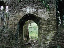
I then came to the little road at Merther, which I joined for a couple of hundred yards. Just before I turned off the road onto another track I came across a ruined church on the right. I had a look around this and it as quite a sight; the porch had only half a roof and the roof of the main church had fallen in, as had the columns of an arcade down the middle of the church. Only the tower was substantially intact, and the walls were quite severely bowed in place. It is strange to see plants and even small tress growing inside a church, and although I wanted to explore further I was worried about the state of the structure. In the past I have found other ruined churches to be quite spooky, but this was not and indeed I fond it quite dignified in its ruin.
As I walked down the next track I could see that the collie dog was still following me. I phoned Sam to ask her what I should do, and she suggested that I point back in the direction where I first met the dog and shout 'Home!'. I did this, but the dog just got more excited and ran around me. By this time I was getting slightly more concerned that I may have inherited the dog, so when I passed the farm at Treffry I called I but no one was at home. I considered trying to create a lead for the dog using some para cord that I always keep with me, but the dog had no collar and I was unsure how I could safely fashion one.
Shortly after this I reached a public road, and although this was quiet a couple of cars passed along it whilst I descended down towards a main road. It was obvious that the dog had no road sense, as it was running across the road all the time, even when the cars were approaching. I got to the main road and crossed the bridge over the River Tresillian, and the dog was still running over the road. The first building that I reached was a small garden centre, so I took the dog in there, where a nice lady called Debbie was working. I told her the situation, and I asked if she had a spare dog collar so that I could tie the dog up but unfortunately she did not have one,
Debbie got onto the phone to the local RSPCA, but whilst she was on the phone to some other numbers that they gave her the dog ran out of the room and onto the pavement beside the main road. I ran out after it, but when I called her back she ran right past me and into the road. A couple of cars passed her, but one then hit her from behind and threw her a few feet onto the other side of the road. Fortunately the traffic stopped, and I ran over to her, picked her up and carried her back into the garden centre. Debbie was still on the phone, this time to a dog warden, and I will find it hard to forget the look on her face when I carried the dog in. A few minutes after I put her on the floor her tail started to wag and she was moving her forelegs, which cheered me up as it could have been much worse.
The dog warden was unsure when he could come, so I phoned Sam up to see if she could take it to the vets. Fortunately after about fifteen minutes the dog warden came, and Sam arrived as I was opening the doors of the van for the dog to be put in. I phoned up the vets tonight and the owners of the dog have been found, despite the dog not having a collar or chip (I gave the warden the grid reference of where I first saw the dog, which is how they must have traced the owners). She has been X-rayed and she is being kept in overnight, so I hall ring tomorrow to check how she is.
I feel really guilty, as I should have tried harder to get the dog to go back to where she joined me, but I did not really have any way of controlling her. To make matters worse, because she joined me in a field away from the farm I was unsure where she came from or even if she was a stray. By the time I realised that she was following me and was not going to turn back I was a long way away from where we had met. Hindsight is a wonderful thing, and I wish I could have done things differently.
When I got into Truro I found and Internet Cafe and spent three quarters of an hour checking and replying to emails, as I had not done this for a few weeks and I had many stacked up awaiting replies. By the time that I had done this it was getting late, but I decided to press on for another few miles, and luckily I managed to get this done before it got dark.
On another, slightly more positive, note tomorrow I shall have reached 2,000 miles in total on this walk, which is quite a nice figure and one that we shall have to celebrate reaching tomorrow. I am very aware that I still have over 3,500 miles to go, but despite this reaching 2,000 miles gives me a very nice feeling.
Directions
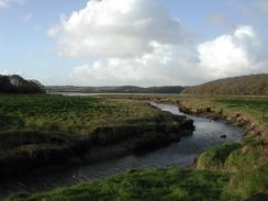
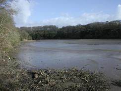
This walk starts at the church in Ruan Lanihorne. Walk past the church and then take a road that leads off downhill to the left, which descends down onto a floodplain. When the road ends at a junction turn right and follow a road that heads westwards along the northern side of the Ruan River until it turns to the right and reaches a a bridge over the River Fal.
Cross the bridge and continue on along the road a it climbs uphill through Lamorran Wood. The road then descends to cross a stream before ascending up on the other side for a short distance before ending at a T-junction. Turn left along this road and follow it through the village of Lamorran, where it turns to head in a more westerly direction as it heads through an area of woodland. Eventually this road crosses a private driveway before ending at a T-junction with another road near Tregonian.
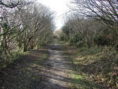
Turn right down this road and follow it as it descends to cross the private driveway once more, this time on a bridge, in Merther Lane. After another kilometre turn to the left down a surfaced driveway. This driveway passes the farm at Tresawsan before becoming unsurfaced and continuing on down a rough track and then up to end at a road in Merther. Turn right down this road, passing the remains of a ruined church on the right, before taking another track that leads off to the left.
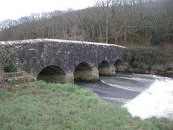
This track heads northeastwards, passing through a farm at Treffry before ending at a road. Turn left to descend down the road for a short distance before it ends at the A390 main road. At the main road turn left to head ssouthweatwards for a little over a kilometre, crossing the River Tresillian on a bridge before passing a garden centre and the Wheel Inn. Continue on out of the village, until the road turns sharply to the right where a footpath leads off to the left. Turn left down this footpath that crosses a stream before ending at a track. Turn left down this track, which immediately turns around to the right to head down the western bank of the River Tresillian. This eventually emerges at a road in St Clement, which can then be followed uphill past the church. Just past the church turn left up a footpath that initially heads along the driveway to Churchtown Farm before heading on uphill. It then descends down into some woodland and over a stream before ending at a road in Malpas.
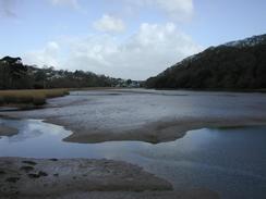
Follow the road as it heads through Malpas beside the river, before it turns sharply to the right to head northwestwards along the eastern bank of the Truro River for a couple of miles until it ends at a dual carriageway. Turn left down this carriageway (which has a pavement alongside it) over two bridges over the Truro River and then at a roundabout take the first road to the left. This road passes the entrance to an Tesco supermarket before hading into a more industrial area. When the National Cycle Network Route 3 heads off to the right follow it onto an old railway trackbed, which the path follow southwards before turning to the right to head westwards for a little over a kilometre before ending at a road.
Turn left down the road for a short distance until it ends in the village of Calenick. At the end of the road turn left to head straight on up another road and then take the first road off to the left, which heads uphill to Porthkea. When the road ends in Porthkea turn to the left and follow another road uphill, and just after the top of the hill turn right down another road to head southwards past the farm at Higher Lanner. This road descends down to the end of a creek at Cowlands before rising up on the other side. When the road turns sharply to the right continue straight on down a track that is part of the National Cycle Network Route 3. This descends downhill before rising steeply uphill and ending at the B3289 road. Cross this road and continue straight on southwards through the little hamlet of Trevilla and into Feock, where this walk ends at a car park on the left.
Distances
| From | To | Distance (m) | Ascent (ft) | Descent (ft) |
|---|---|---|---|---|
| Ruan Lanihorne | Tressillian | 6.6 | 866 | 889 |
| Tressillian | Truro | 5.0 | 551 | 568 |
| Truro | Feock | 5.0 | 758 | 725 |
This makes a total distance of 16.6 miles, with 2175 feet of ascent and 2182 feet of descent.
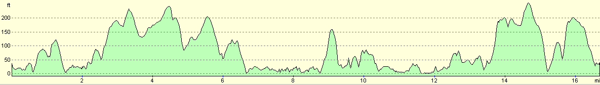
For more information on profiles, ascents and descents, see this page
Accommodation
We parked in a car park in Feock, which was a very handy place to stop for the night. It was also fairly sheltered, which was fortunate as it was exceedingly windy during he night. Unfortunately there were no facilities (i.e. pubs or public toilets) about in the village which we could use, but that was a small price to pay for the convenience of the site.
Disclaimer
Please note that I take no responsibility for anything that may happen when following these directions. If you intend to follow this route, then please use the relevant maps and check the route out before you go out. As always when walking, use common sense and you should be fine.
If you find any information on any of these routes that is inaccurate, or you wish to add anything, then please email me.
All images on this site are © of the author. Any reproduction, retransmissions, or republication of all or part of any document found on this site is expressly prohibited, unless the author has explicitly granted its prior written consent to so reproduce, retransmit, or republish the material. All other rights reserved.
Although this site includes links providing convenient direct access to other Internet sites, I do not endorse, approve, certify or make warranties or representations as to the accuracy of the information on these sites.
And finally, enjoy your walking!
This walk was mentioned in the following routes:
| My walk around the coastline of Britain |
| South West Coast Path |
Nearby walks
| # | Title | Walk length (miles) |
|---|---|---|
| 339 | Mevagissey to Portscatho | 18.3 |
| 340 | Portscatho to Ruan Lanihorne | 17.9 |
| 342 | Feock to Falmouth | 15.4 |
|
|

|