Walk #338: Fowey to Mevagissey
 |
 |
|
General Data
| Date Walked | 26/01/2003 |
| County | Cornwall |
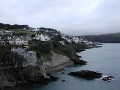
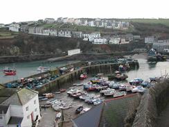
| Start Location | Fowey |
| End Location | Mevagissey |
| Start time | 08.20 |
| End time | 16.38 |
| Distance | 16.9 miles |
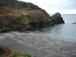
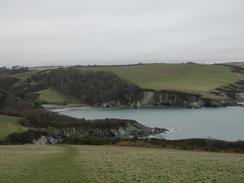
| Description | This was a lovely although strenuous walk following the South West Cost Path around St Austell Bay. |
| Pack | Today I carried my 30-litre Karrimor HotRock rucksack, which was filled with my packed lunch, waterproof leggings, water bottle and a couple of spare shirts, together with the usual assortment of odds and ends. |
| Condition | I feel absolutely fine after this walk, and I could easily have walked further if the hours of daylight had permitted. I had very little trouble with my bad ankle, which is a relief after the trouble I had with it the other day. |
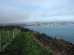
| Weather | Today was a cloud day, but for most of the time the cloud as a hundred metres or so above the top of the cliffs. Despite this it never rained, and the only sign of precipitation was on a couple of occasions when the cloud layer fell whilst I was on the cliffs, so I walking through the cloud. Later on the cloud state to lift and there were some sunny spells, but the strong wind meant that these did not linger too long. It was a very warm day for the time of year, and indeed one place in Scotland recorded the joint highest temperature ever recorded in January - eighteen degrees Celsius<. /TR> |
| OS map | Landranger number 204 (Truro & Falmouth, Roseland Peninsula) |
 |
 |
|
 |
 |
|
Map of the walk
Maps courtesy of Google Maps. Route for indicative purposes only, and may have been plotted after the walk. Please let me have comments on what you think of this new format. For a detailed table of timings for this walk, please see the table file.
 |
 |
|
 |
Notes
I found this walk quite hard going, as can be seen from the fact that it took me eight hours to do sixteen miles - a slow average of two miles an hour. Despite this I did not tire myself out too quickly and I found that I could push myself up the steep ascents without having to stop, even when they came one after another. An example is the short distance between Pentewan and Mevagissey had three steep ascents before I finally reached the end of the walk, and this shot section took me some time. Despite this I could have walked further if time had allowed, but I did not have much time left before it got dark, and certainly not enough time to reach Portmellon. This was the next place that Sam could have picked me up and was three miles away.
I am getting quite near to having walked 2,000 miles, a target that I should reach in four or five days. It will be a really nice feeling to reach this target, and I find it amazing to think how far I have come in the last 1,000 miles, yet alone the last 2,000 miles from Edinburgh.
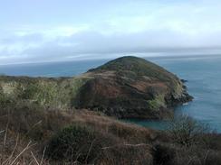
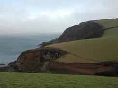
The daymark on Gribbin Head was visible for almost all of the day, from just past it to the hills above Mevagissey. This strange 84 foot high tower - painted red and white on three sides and white on the other side facing inland - was built in 1832 to help vessels tell the difference between this headland and the similar one at the entrance to Falmouth. The views from this headland were quite good despite the low cloud; on a clearer day there could be some very good views indeed. Black Head on the other side of the bay could also give some good views, and the promontory itself is quite impressive. I walked up to the top of the headland and sat down for five minutes, admiring the views across the bay before continuing on the hard walk.
Sam spent the day at the Eden project, which was something that she had very much been looking forward to going and visiting. It sounds as though she massively enjoyed this trip, and she was full of talk about it all evening. The Eden project is certainly a visionary project, and even better it is one that has a purpose and reclaims otherwise useless land - an old china clay quarry. I w9uld not have minded having a look around as well, but I could not justify taking a day off the walk.
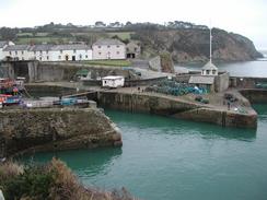
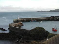
I was most impressed with Charlestown. This little harbour had three sailing ships berthed, and the whole place seemed quite picturesque. The harbour was built in 1791 by Charles Rashleigh, a mining entrapaneur and whose family were mentioned in several places on this walk between Fowey and Charlestown. I went into the Pier House Hotel on the quayside so that I could use their facilities and have a pint. This pub was very nice, and some of the food that they were serving up looked absolutely superb. I was very tempted to have a meal, but I had not yet eaten the sandwiches that Sam had made me and I could not justify the expense.
Tomorrow I will continue to walk along the South West Coast Path towards the start of the Fal Estuary. I will have to walk around this large estuary, which should take me a couple of days as I will have to go as far north as Truro. Immediately after the Fal estuary I have another, smaller, estuary to cross - the Helford River. After this I have a straightforward walk to and beyond Land's End, which I am thankful for as I am getting slightly fed up with having to walk around all these estuaries.
Directions
| During this walk I followed the South West Coast Path, the route of which is detailed in the Ordnance Survey National Trail Guide 10, Falmouth to Exmouth (ISBN 1-854108-90-5). Unfortunately the route description is written in reverse to the direction that I am walking, but the 1:25,000 maps in the book are clear and the signs on the ground are very good. Also to be recommended is the South West Coast Path Association guidebook (ISBN 0-907055-04-4), which has less concise directions and no maps, but includes accommodation details and grades each section of the walk according to difficulty. They also publish reverse directions, which are suitable for walking in the direction that I walked the route. They have a website at www.swcp.org.uk, which is well worth a visit. | 
|
| 
| |
| |
| |
Distances
| From | To | Distance (m) | Ascent (ft) | Descent (ft) |
|---|---|---|---|---|
| Fowey | Polkerris | 4.6 | 1381 | 1368 |
| Polkerris | Charlestown | 5.5 | 1060 | 1060 |
| Charlestown | Mevagissey | 6.8 | 2195 | 2254 |
This makes a total distance of 16.9 miles, with 4636 feet of ascent and 4682 feet of descent.
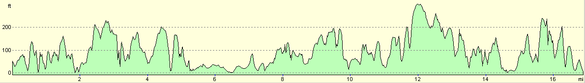
For more information on profiles, ascents and descents, see this page
Accommodation
We stayed at a car park in Mevagissey, as there did not really seem to be any parking anywhere else. There was no way we were going to try to get Mervan further into the village to see if there was any on-street parking.
Disclaimer
Please note that I take no responsibility for anything that may happen when following these directions. If you intend to follow this route, then please use the relevant maps and check the route out before you go out. As always when walking, use common sense and you should be fine.
If you find any information on any of these routes that is inaccurate, or you wish to add anything, then please email me.
All images on this site are © of the author. Any reproduction, retransmissions, or republication of all or part of any document found on this site is expressly prohibited, unless the author has explicitly granted its prior written consent to so reproduce, retransmit, or republish the material. All other rights reserved.
Although this site includes links providing convenient direct access to other Internet sites, I do not endorse, approve, certify or make warranties or representations as to the accuracy of the information on these sites.
And finally, enjoy your walking!
This walk was mentioned in the following routes:
| My walk around the coastline of Britain |
| South West Coast Path |
Nearby walks
| # | Title | Walk length (miles) |
|---|---|---|
| 335 | Freathy to Polperro | 16.0 |
| 336 | Polperro to Penpoll | 13.1 |
| 337 | Penpoll to Fowey | 15.6 |
|
|

|