Walk #337: Penpoll to Fowey
 |
 |
|
General Data
| Date Walked | 25/01/2003 |
| County | Cornwall |
| Start Location | Penpoll |
| End Location | Fowey |
| Start time | 08.30 |
| End time | 15.46 |
| Distance | 15.6 miles |
| Description | This was a nice but not spectacular walk up the western side of the River Fowey to Lostwithiel, which was followed by a walk mainly along roads south into Fowey. |
| Pack | Today I carried my 30-litre Karrimor HotRock rucksack, which was filled with my packed lunch, waterproof leggings, water bottle and a couple of spare shirts, together with the usual assortment of odds and ends. |
| Condition | I feel absolutely fine after this walk, and I do not have any problems to report. The problems with my ankle that I had yesterday eased during today, and after a while it was fine, which I am extremely thankful for. |
| Weather | The weather today was quite nice once again, with some sun and much cloud. There was no sign of any rain, and the wind compensated for the mild temperatures. All in all it was a nice day for a awalk. |
| OS map | Landranger number 200 (Newquay & Bodmin, Camelford & St Austell) |
 |
 |
|
 |
 |
|
Map of the walk
Maps courtesy of Google Maps. Route for indicative purposes only, and may have been plotted after the walk. Please let me have comments on what you think of this new format. For a detailed table of timings for this walk, please see the table file.
 |
 |
|
Notes
I got lost twice today, which is quite unusual. The first of these was at Cliff, when I followed a public footpath sign that led down to the foreshore, but this was not the path that I was meant to follow. This was unfortunate, and as I walked along the foreshore and slid over on a slippery rock. The second time that I got lost was also my fault, as I spent about twenty minutes walking around the village of Golant looking for the correct path, during which time I walked past a little way marker twice without seeing it. This was highly silly, and I must have been in a world of my own whilst I was looking. It was fortunate that today was not too long a day, as I probably lost three quarters of an hour on these silly escapades, which was quite a delay for this time of year.
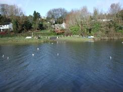
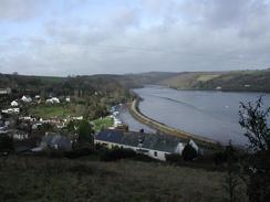
I met Sam at the car park in Lerryn and at the station car park in Lostwitheil. At the latter I sat down on the step into Mervan and ate my sandwiches whilst we had a quick chat. It is nice meeting up with Sam during the walk, although at this time of year with limited daylight hours I do not have the ability to stop for a long time if I am going to be doing a long distance that day. Lerryn is a lovely little place, although as the tide was high I could not cross the stepping-stones and had to go over the bridge. In the car park at Lerryn we met some people who we met the previous night in the pub, and we had a quick chat before I continued on.
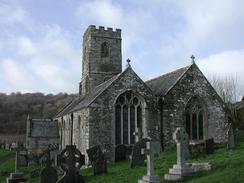
I visited three churches on this walk today - St Winnow Church in St Winnow, St Sampson in Golant and St Fimbarrus in Fowey. All of these churches were quite nice, but I particularly liked the intricate carved bench ends in St Winnow Church. It is nice to see churches in the middle of the country that are kept unlocked and open to the public, as so many are kept locked nowadays.
Many of the churches - and even towns - are named after saints whose names are not familiar to people who live elsewhere in England. In the area that I walked around today I passed references to St Sampson, St Winnow, St Fimbarrus, St Nectar and St Veep, all of whom I had never relly heard of before. Many of these saints are Celtic in origin, as the Saxon's did not really get to this part of England until very late, and their influence on the area was minimal.
Lostwithiel was quite a nice little town and I had a quick walk around it before continuing on out of the town. It was doubly nice as it was the end of another estuary, and reaching it meant that I was heading back to the sea once more. The church in the town looked quite nice from the outside, but unfortunately it was not open for visitors - it is only open at certain times during the summer.
This evening we went out into Fowey and visited the local pub collecting money. We also treated ourselves and had a meal of fish and chips in one of the pubs, as we were hungry and wanted something to eat. This was more expensive than we really wanted, but we are below budget for the week and felt like treating ourselves for once. We had tried looking for a fish and chip shop as I really desired some nice and greasy fish (as only a good British fish and chip shop can provide), but the two in Fowey were both shut for the winter, which was annoying.
Tomorrow I shall be walking along the South West Coast Path once more, and it shall be nice to be doing this after a fairly annoying and boring walk around an estuary.
Directions
| During this walk I followed the South West Coast Path, the route of which is detailed in the Ordnance Survey National Trail Guide 10, Falmouth to Exmouth (ISBN 1-854108-90-5). Unfortunately the route description is written in reverse to the direction that I am walking, but the 1:25,000 maps in the book are clear and the signs on the ground are very good. Also to be recommended is the South West Coast Path Association guidebook (ISBN 0-907055-04-4), which has less concise directions and no maps, but includes accommodation details and grades each section of the walk according to difficulty. They also publish reverse directions, which are suitable for walking in the direction that I walked the route. They have a website at www.swcp.org.uk, which is well worth a visit. | 
|
| 
| |
| |
| |
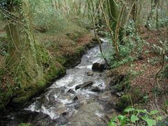
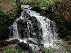
This walk starts off by the bridge over Penpoll Creek in Penpoll. Head uphill westwards through the village and when it reaches a junction with the road to the right protected by 'no entry' signs follow the road to the left. When this curves uphill to the right continue straight on westwards along a narrower road. This road passes the farm at St Cadix and then Haye Farm. When the road curves sharply to the right beyond Haye Farm take a footpath that leads off to the left. This footpath heads downhill along the edge of a field before turning to the right and descending northwards until it reaches the southern bank of a little stream. Turn left and follow the stream downhill until it meets a road in Cliff.
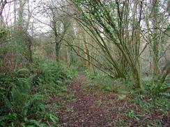
Turn right along the road in Cliff and follow it for a couple of hundred yards until it turns sharply to the right to head uphill. A few yards beyond this bend a footpath heads off to the left. Follow this footpath as it skirts through woodland along the southern bank of the River Lerryn for nearly two kilometres until it nears Lerryn. Here the path forks; you can either take a lower footpath beside the river or a higher footpath that joins an access road and then ends at the road in Lerryn. Turn left down this road for a short distance past the pub to the car park, which is also where the lower footpath ends.
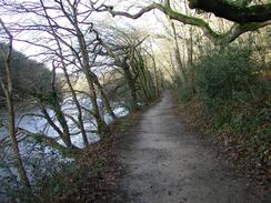
If the tide is low then you can cross the stepping stones onto the northern side of the river. If the tide is high, then you will have to follow the road through Lerryn to the bridge over the river. Cross the bridge and then take the first road to the left, which soon curves down to meet the northern bank of the river where the stepping-stones end. Continue along the lane alongside the northern bank of the river until a house is reached, Here the path passes immediately to the right of the house and becomes a nice and wide track through the trees of the Ethy Estate. The track winds around a little inlet before entering Great Wood. Through Great Wood the track slowly becomes a narrower footpath before turning to head northwestwards alongside the River Fowey. Eventually it leaves the woodland and descends down onto the foreshore of the river below St Winnow Church. Beyond the church climb up off the foreshore and join the road beside the church.
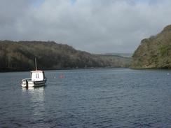
Turn left to head up this road. Immediately after you pass under some power lines the road curves to the right; here take a track that leads straight on downhill. The track crosses a stream before climbing uphill and ending at a public road near the driveway down to Newham Farm. Continue straight on along this road for a mile until you reach the B3268 road in Lostwithiel. Turn left down the B3268 road for a short distance as it crosses a level crossing by the railway station and then crosses the River Fowey on an attractive bridge. Carry straight on uphill past the church until the A390 is reached, and then turn left along this road through the centre of the town.
When the A390 road turns to the right continue straight on uphill along another road. This road passes a junction to the right and passes a cemetery where it turns to head southwards and descends down into Castle. In Castle the route I take joins the route of the Saints Way, which is fairly well waymarked. The road crosses a bridge over a stream to the south of Castle before it turns to the left to head southeastwards into Milltown. The road curves to the right and climbs up under the railway line and into Lantyan. Here follow the road as it curves to the left (do not take the road off to the right) as it climbs up and down past Lantyan Wood. On the last ascent take a footpath that heads off uphill to the left and leads on to the church in Golant. The footpath meets the road just before the church, so turn left along the road past the church. It then turns to the right to head steeply down into Golant.
Follow the Saints Way markers through Golant and out the other side, until it reaches a stream at the bottom of Colvithick Woods. The path then climbs uphill through the woodlands before emerging out into a field. Follow the path across the field until it ends at a road beside a barn in Penventinue. Turn left to head south down this road for a little over a kilometre until it ends at the B3269 road. At the junction turn left to head eastwards down the B3269 for a little under a kilometre until it turns sharply to the right by the ferry-landing place. This walk ends at the car park on the left at this bend.
Distances
| From | To | Distance (m) | Ascent (ft) | Descent (ft) |
|---|---|---|---|---|
| Penpoll | Lostwithiel | 8.2 | 1542 | 1539 |
| Lostwithiel | Fowey | 7.4 | 1516 | 1470 |
This makes a total distance of 15.6 miles, with 3058 feet of ascent and 3009 feet of descent.
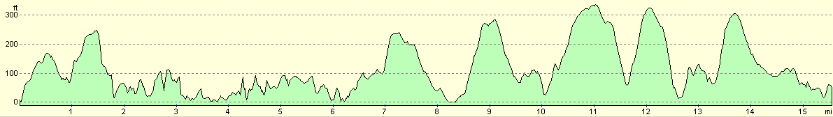
For more information on profiles, ascents and descents, see this page
Accommodation
We parked in the main car park in Fowey, which is situated a little distance above the town. This car park was free to park in at this time of year, but does not allow overnight parking. Were pretty much forced to do this, however, as we could find nowhere else suitable to park in the town, and we are relying on there being no inspectors about as the ticket machines are covered for the winter.
Disclaimer
Please note that I take no responsibility for anything that may happen when following these directions. If you intend to follow this route, then please use the relevant maps and check the route out before you go out. As always when walking, use common sense and you should be fine.
If you find any information on any of these routes that is inaccurate, or you wish to add anything, then please email me.
All images on this site are © of the author. Any reproduction, retransmissions, or republication of all or part of any document found on this site is expressly prohibited, unless the author has explicitly granted its prior written consent to so reproduce, retransmit, or republish the material. All other rights reserved.
Although this site includes links providing convenient direct access to other Internet sites, I do not endorse, approve, certify or make warranties or representations as to the accuracy of the information on these sites.
And finally, enjoy your walking!
This walk was mentioned in the following routes:
| My walk around the coastline of Britain |
| South West Coast Path |
Nearby walks
| # | Title | Walk length (miles) |
|---|---|---|
| 335 | Freathy to Polperro | 16.0 |
| 336 | Polperro to Penpoll | 13.1 |
|
|

|