Walk #754: Hatfield Peverel to Colchester
 |
 |
|
General Data
| Date Walked | 01/01/2007 |
| County | Essex |
| Start Location | Hatfield Peverel station |
| End Location | Colchester North station |
| Start time | 08.20 |
| End time | 15.17 |
| Distance | 20.4 miles |
| Description | This was a long and fairly uninteresting road plod, although some pretty villages were passed on the walk. |
| Pack | Today I carried my 30-litre Karrimor rucksack filled with my waterproofs, two litres of water, and various other odds and ends. |
| Condition | I feel relatively okay after this walk; my left knee ached occasionally, but aside from this I had no other problems. |
| Weather | The day started off slightly cloudy with patches of sunshine; however, the cloud soon lifted, and I was left with a bright sunny, if slightly chilly, day, with very little cloud in the sky. |
| OS map | Landranger number 167 (Chelmsford, Harlow & Bishop's Stortford) and Landranger number 168 (Colchester, Halstead & Maldon) |
 |
 |
|
 |
 |
|
Map of the walk
Maps courtesy of Google Maps. Route for indicative purposes only, and may have been plotted after the walk. Please let me have comments on what you think of this new format. For a detailed table of timings for this walk, please see the table file.
 |
 |
|
 |
 |
|
Notes
On the map of my walks there was an obvious gap in Essex, between the walk from London to Hatfield Peverel and Colchester; it had been over a year since I had last walked a walk on this stretch, and today I resolved to fill in the gap. It was also the first day of the year, and I quite fancied getting an early walk in. I therefore set off early in the morning, and about an hour later I was parking up in the car park at Hatfield Peverel. The roads had been very quiet, and on the M11 there had scarcely been a car in either direction.
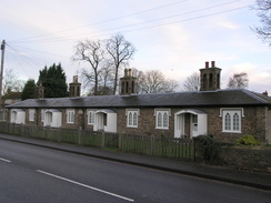
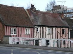
I slowly pulled my kit together and put my boots on, particularly concentrating on setting my brand-new GPS up, which had been a present from my girlfriend. Hatfield Peverel had some relatively pretty buildings, and I looked at these on the nearly-deserted new year streets. A shop was open but I did not bother going into it, and after passing the village sign I continued on. Once the pavement ended I headed on carefully along the road, but there was virtually no traffic, but it was nonetheless a relief when I turned off along a minor road.
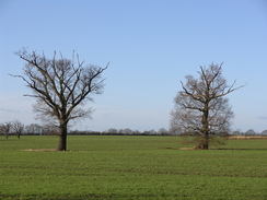
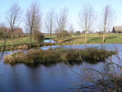
This road passed a fishing lake on the left, before curving around and taking me on eastwards, with more lakes on the right, seemingly the remains of old sand pits. As the entire day was going to be on roads I had decided to wear trainers instead of my boots, and as I had been on four-mile runs for the previous couple of days my legs were fairly stiff. The roads were wet after the recent rain, although the generally blue skies overhead made me fairly confident that my feet would not get too wet.
More roads took me on, descending down to cross the River Blackwater by the red-brick Wickham Place. To the left from the bridge I could see an old wooden viaduct, restored in 1995, behind Wickham Mill, which used to carry the Witham to Maldon railway line. The road then climbed to cross over the railway line on a bridge; the area underneath was overgrown and looked more like a canal, although the old station to the north was in better condition, with the platform edges painted in white.
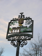
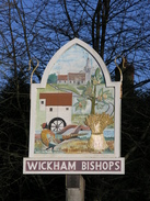
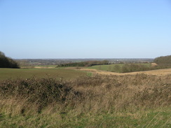
The road climbed uphill, before reaching Wickham Bishops church, which I took a few photographs before heading on along the road through the village. At a crossroads there was a war memorial, and after this I plodded on to reach another crossroads at Beacon Hill. Off to the right there was actually a beacon, and I diverted off the road for a few yards to reach the trig pillar, from which there were some hazy views down southwards towards Maldon and the Blackwater Estuary. A long road walk took me on towards Great Braxted, and it was very chilly on the exposed ridge in the wind.
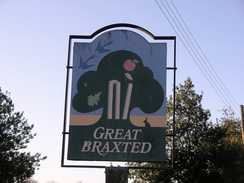
Great Braxted has a nice village sign, comprising of an apple falling and knocking off the bails on some cricket stumps - surely an archetypal English image. The village was small and I had soon exited it and continued on northeastwards towards Tiptree, as the few clouds eventually cleared and there were blue skies all around, although the winds were still chilly. A large reservoir was passed on the left before the road entered Tiptree. I used roads to skirt around the northern side of the two, and this tool me past the Maypole Inn, now a Thai restaurant, and I headed up along roads towards Messing, passing Messing Park on the way.
Messing church was fairly pretty, with a square brick tower rising above the adjacent trees, and outside it there was a simple stone war memorial. The main area of Messing itself was attractive, and one building near the church had a plaque denoting it as being Almhouses in 1748, a workhouse in 1799, village school in 1836 and finally the village hall in 1911, which is quite a change in usage! A road took me on, and some old Austin Seven's passed me, with people wrapped up well against the cold sitting in the seats.
Beside the road there was a gate leading into a field, which had been left rather redundant as the hedges on either side had been removed, leaving the gate standing proud and alone. I was surprised that it had not been removed, but a little further on I spotted another one, this one having nearly been submerged under ivy. A series of road junctions allowed me to skirt Easthorpe and head eastwards to reach the B1022. The road was busy and although it proved easy to follow down to the pub at Heckfordbridge, the next hundred yards uphill were awkward as the verges were non-existent and there was a long queue of traffic streaming past.
It was a relief when I could turn off the road and head north along another road, especially when a pavement started on the left just before the entrance to a working Tarmac sand and gravel pit was reached on the left, heading towards Stanway. Dyer's Road took me on towards Colchester, and another road took me on to Gryme's Dyke, the remains of a first Century BC pre-Roman defensive bank system; the three miles of Gryme's Dyke is the largest surviving stretch, although there are some remains of Lexden Dyke elsewhere in the city.
More road took me onwards, and there little really to see as I headed in towards Colchester. I was unsure which station my train back to Hatfield Peverel would go from, and in the end I decided to head off towards the northernmost station, which looked as though it was on the correct rail line. An underpass under a main road was decorated with large replica Roman coins, and as I followed the road northwards I started to see signs of the Roman presence in the town.
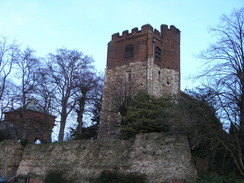
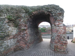
The most obvious of these was the stretch of Roman Wall around the Hole in wall pub, and the adjacent Balkerne Gate, the largest extant Roman gateway in Britain. I studied these for a few minutes, wondering how they had remained so intact for so long, and then went to take few photographs of the massive Grade-II listed Jumbo Water Tower. This was built in 1883 to draw water from an artesian well, and was latterly used as a holding tower for mains water. The tower is constructed of red brick and is 131ft high with arches on each side. It is crenelated around the top and surmounted by a wooden lantern. In the centre a shaft rises to the tank, which is made of cast iron plates tied with iron bars and measures 55ft 7in square and 12ft deep. The tank's capacity is 221,000 gallons. It is soon to be converted into a five bedroom home with a public viewing gallery at the top, and I was glad to find that it was note to be demolished, as had been threatened at one time.
As the path descended down from the Hall in the Wall pub the wall was visible on the right, and although much of it was relatively modern, some earlier layers similar in construction to the Balkerne Gate were visible lower down. The wall was soon left behind as I headed on towards the railway station; on the way I passed an unusual public water fountain, and my feet were getting very tired by the time I finally reached the station. I purchased a ticket and went on to the platform, relieved that I did not have long to wait for the train back to Hatfield Peverel and my car.
Directions
This walk starts off at Hatfield Peverel railway station. Leave the station and walk through the small car park to reach Station Road; turn left and head south down Station Road. This soon crosses the A12(T) on a bridge before ending at the B1137 road in the village. Turn left to head east along the B1137 through the village, before turning right down the B1019 Maldon Road opposite the car park of the Duke of Wellington pub. Follow this road southeastwards as it heads out of the village, and after passing a farm on the right turn left up Wickham Bishops Road.
Initially this road heads northwards, before curving sharply to the right to head eastwards as it passes Lane's Farm and ends at a T-junction with Hatfield Road. Turn left along this road to head northwards for a hundred yards, and then turn right to start following the B1018 road eastwards. The road starts to curves to the right to cross the River Blackwater on a bridge, before climbing up to cross an old railway line on a bridge.
Shortly after this the B1018 road curves sharply to the right; here continue straight on along Station Road, which heads slightly north of east before ending at a T-junction with Wickham Hall Lane. Turn left to head north along this lane for a few yards, and then turn right along Church Road. This immediately passes the church on the right, and when the road curves to the right turn left to continue along Church Road, which heads northeastwards. At a crossroads this becomes Tiptree Road, and continue along this, ignoring Carters Lane coming off to the left before coming to another crossroads. Here continue straight on along Beacon Hill Road, and after a short distance a crossroads is reached on Beacon Hill.
At this junction turn left along a road to head northwards; this soon curves to the right and starts heading slightly north of northeastwards. After a mile the village of Great Braxtred is reached; continue straight on along the road through the village, climbing uphill before reaching a crossroads with a larger road. Carefully cross this road, and continue on northeastwards on the other side. The road passes a mast on the right, and heads on towards Windmill Hill. The road passes a reservoir on the left, and then curves around to reach the B1023 Kelvedon Road.
Cross the B1023 and continue straight on northwards for a hundred yards up Townsend Road until it ends at a T-junction, and then turn right to head eastwards down Oak road. When this ends at the B1022 Maypole road turn left to join the road for a few yards, and then turn left to head northwards along a road. The road skirts the eastern edge of Messing Park, and when a road junction is reached on the right by a school turn right to head northeastwards down School Road. This road descends slightly and then turns to the left, shortly ending at a T-junction with another road. Here turn right and walk eastwards along a road that skirts past Messing Church before ending at another T-junction in the village.
Turn left along Lodge Road, and follow this road as it twists northeastwards for a couple of miles, as it passes Messing Lodge on the left. At Cantfield's Farm the road curves to the left to head northwards towards Easthorpe. About half a mile before the village is reached turn right shortly after Winterflood's Farm, to follow another road eastwards for about a third of a mile until it ends at a T-junction. Here turn left to head slightly east of north for about a kilometre, passing to the left of Whitehouse Farm before reaching a complex road junction.
Here turn right for a few yards, and when the road curves to the left turn right along another road that heads initially northeastwards before curving to head in a more easterly direction, passing to the north of a little lake before ending at a road junction. Turn right and head southeastwards along a road that twists around for a few hundred yards towards Bockingham Hall Farm, but when the road curves to the right for a second time turn left along Fountain Lane. This heads slightly north of eastwards for half a mile, before curving sharply to the right to head southeastwards up a slight hill for a few hundred yards until it ends at a T-junction with the B1022 road in Heckfordbridge.
The road heads northeastwards, descending downhill to cross a stream by a pub, after which the road curves to the left to head northwards uphill. Here the road narrows and you have to be careful for a couple of hundred yards on the climb as the verges are narrow. When the road soon curves to the right continue straight on down Warren Lane, which heads northwards for about a kilometre, passing a sand and gravel pit on the left, until Dyer's Road leads off to the right.
Turn right and follow Dyer's Road as it heads northeastwards for about half a mile before ending at a complex junction at Five Ways. Here turn right and follow Peartree Road eastwards for a kilometre, as it becomes Dugard Avenue before ending at a T-junction with Straight Road. Turn right and head southeastwards along Straight road until it ends at a junction with the B1022 road in Shrub End. Here turn left and follow the B1022 northeastwards for about half a mile. At some traffic lights the road curves slightly to the right, and a short distance after this turn left down Maldon Road.
Head northeastwards along Maldon Road for about a mile until it ends at a roundabout with the A1124 and A134 roads. Turn left to descend into a subway to pass under the A1124, and then head northwards along the A134 dual carriageway. The pavement rises up to meet a footbridge over the road, and turn right to cross this bridge to reach the Hole in the Wall pub, and then turn left to start heading northwards downhill to another roundabout.
Turn right at this roundabout to head eastwards for about a hundred yards, and at some traffic lights turn left to head northwards. This road soon ends at a roundabout; continue straight on and then cross to the western side of the road; the road that leads up to the railway station is a few yards ahead on the left, just before the railway bridge over the road is reached.
Distances
| From | To | Distance (m) | Ascent (ft) | Descent (ft) |
|---|---|---|---|---|
| Hatfield Peverel | Wickham Bishops church | 3.9 | 230 | 151 |
| Wickham Bishops church | Tiptree | 4.9 | 148 | 151 |
| Tiptree | Heckfordbridge | 6.1 | 105 | 256 |
| Heckfordbridge | Colchester station | 5.5 | 210 | 207 |
This makes a total distance of 20.4 miles, with 693 feet of ascent and 765 feet of descent.
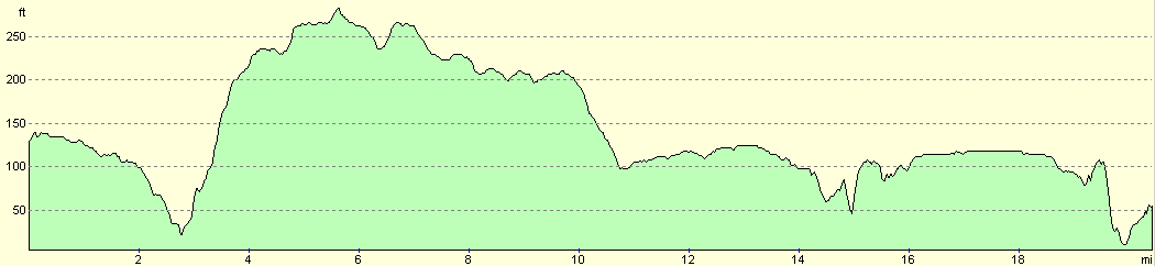
For more information on profiles, ascents and descents, see this page
Transport
There are regular train services from Colchester North station to Hatfield Peverel, which cost me Ł5.90 for a single ticket for the twenty minute journey. See the National Rail Enquiries website for more details.
Disclaimer
Please note that I take no responsibility for anything that may happen when following these directions. If you intend to follow this route, then please use the relevant maps and check the route out before you go out. As always when walking, use common sense and you should be fine.
If you find any information on any of these routes that is inaccurate, or you wish to add anything, then please email me.
All images on this site are © of the author. Any reproduction, retransmissions, or republication of all or part of any document found on this site is expressly prohibited, unless the author has explicitly granted its prior written consent to so reproduce, retransmit, or republish the material. All other rights reserved.
Although this site includes links providing convenient direct access to other Internet sites, I do not endorse, approve, certify or make warranties or representations as to the accuracy of the information on these sites.
And finally, enjoy your walking!
Nearby walks
| # | Title | Walk length (miles) |
|---|---|---|
| 270 | Brightlingsea to Fingringhoe | 15.2 |
| 271 | Fingringhoe to Tollesbury | 16.7 |
| 272 | Tollesbury to Maldon | 17.2 |
|
|

|