Walk #271: Fingringhoe to Tollesbury
 |
 |
|
General Data
| Date Walked | 19/11/2002 |
| County | Essex |
| Start Location | Fingringhoe |
| End Location | Tollesbury |
| Start time | 07.55 |
| End time | 14.32 |
| Distance | 16.7 miles |
| Description | This was a walk of two halves, the first half being along roads and the second half being along loop around sea banks to Tollesbury. |
| Pack | Today I carried my 30-litre Karrimor HotRock rucksack, which was filled with my packed lunch, waterproof leggings, water bottle and a couple of spare shirts, together with the usual assortment of odds and ends. |
| Condition | For the last couple of miles of this walk I was having some significant pains from my left ankle, more than I can remember having had during any other time of this walk bar the first walk. To make matters slightly more worrying, the aches did not stop after the walk had finished and continued on for most of the evening afterwards. Aside from this I had no other problems of any significance. |
| Weather | We awoke this morning to some heavy rain lashing on the van. Fortunately by the time I came to start the walk this had stopped, and the rest of the day was predominately cloudy, with the odd isolated period of sunshine. There was no sign of any rain whilst I walked, so the day turned out to be far better than it could have been. |
| OS map | Landranger number 168 (Colchester, Halstead & Maldon) |
 |
 |
|
 |
Map of the walk
Maps courtesy of Google Maps. Route for indicative purposes only, and may have been plotted after the walk. Please let me have comments on what you think of this new format. For a detailed table of timings for this walk, please see the table file.
Notes
This was my last night with Mike before he leaves and another friend, Terry takes over. I am sad to see Mike leave as he had done a really good job over the last few days but everyday that passes is a day nearer Sam coming back, and I am really missing her. I am due to meet Terry in Maldon, so I will have to get there relatively early ready for the changeover.
I had a choice to make today about whether or not to walk around Mersea Island. Doing this would break two of the (optional) rules of the walk - I do not have to walk around any islands or along anything where I will have to walk back the same way. In the end I decided that I would not walk it, but during the planning phase I had measured around it, so this will reduce my total mileage by a fair few miles. Fortunately I have already walked more miles than I was meant to get this far, so my overall total of 5,500 miles is not in danger.
The fog which had been a feature of the last two days was thankfully absent today, probably having been washed away from the rain we had this morning. This made the day feel much better, even with the thick cloud that was present for most of the day. This fact along raised my spirits and made the first part of the walk, which should have been a dreary road walk, appear much better.
Once I had left the church in Great Wigborough I went down the road, where I met a couple who were out riding their horses. I stopped and chatted to them for a short while about the walk, and their horses. They seemed a very nice couple, and the lady had at one time worked with the Riding for the Disabled Association in Colchester.
I am getting slightly concerned about my left ankle, which is the one that I have had trouble with in the past. This ankle started aching a few miles from the end of the walk, and for the first time on this trip it continued to ache after the walk had finished. Although it is only a ache and not pain, it is still something that I am slightly paranoid about, and so any slight aches or pains which persist are enough to cause me concern. Hopefully it will have stopped aching by the time I start the walk in the morning.
Directions
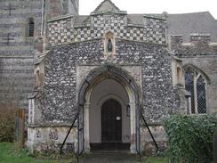
This walk starts off outside the church in Fingringhoe. From the church turn right to walk westwards to a road junction beside a pub. Cross over the junction to head down another road which heads southwestwards for a couple of miles until the road ends at a T-junction with the B1025 road to the south of the village of Abberton.
Carefully cross the B1025 road and take a footpath that heads across a field to the right of a house, crossing the field until you get to an area of woodland. The footpath actually goes through the woodland for a short distance before turning right to end at a road, but I found it easier to turn right and skirt the edge of the woodland to the road as the path through the woodland was narrow.
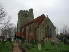
At the road turn left to head southwestwards for a mile into the village of Peldon, passing Pantile Farm and Haxells Farm on the way. Pass Peldon Church and continue on southwestwards until the road ends at a T-junction to the southwest of the village. At the T-junction turn right to head down a road through the little hamlet of Little Wigborough until you reach a road junction on the left, which leads down to a church.
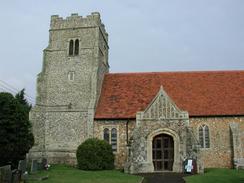
Walk on along the road for a short distance and then turn right down a track that immediately passes through a farmyard before entering a field. In the field the track is fairly indistinct, but when it ends at the end of the field turn left along the edge of the field and start climbing uphill towards the church. I could not find the start of the correct footpath which passes to the left of Moulsham's Farm, so I walked up their driveway which led directly past Great Wigborough Church.
Join the road that starts beside the church and follow this for a short distance downhill until it ends at a T-junction with another road. Turn left down this road and then turn right along a footpath that heaads uphill along a track. The path climbs over the brow of a hill before descending through a farmyard where there are several noisy black Labradors guarding the area. Past the farmhouse the track becomes grassy and continues downhill for a short distance before turning to the left and heading towards a road.
At the road turn right and follow it for a short distance until the B1026 road comes in from the right. Continue on for a short distance past this junction and then turn left down a footpath. This footpath follows the left edge of a couple of fields southwards until a rough track is met. Turn right down this track and follow it through the farmyard of a pig and cow farm. On the other side of the farm the track become a road and less muddy as it continues on to a T-junction with another road. At this road turn left and follow it eastwards past Salcott-Cum-Virley until it ends. At the end join a footpath that heads straight on for a short distance until it meets a sea bank.
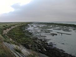
At the sea bank turn right and start following it, with Salcott Creek on the left. The path continues on along the bank for many miles past the Old Hall Marshes until a point is then met near Quarters Spit, with good views of West Mersea being available across the channel. At the point the path and bank start to turn around to head back westwards inland. The path passes Old Hall Farm and then turns to the left to head in a more southwesterly direction. Continue along the bank as it curves to head in a more easterly direction, passing an area where another sea bank to the right has been breached to create salt marsh. Continue on along the bank until just before a water treatment plant is reached, and then turn right down a footpath along the edge of a field which soon turns to the left and joins the concrete track which leads up to the Woodrolfe Green car park, where this walk ends.
Distances
| From | To | Distance (m) | Ascent (ft) | Descent (ft) |
|---|---|---|---|---|
| Fingringhoe | Salcott-cum-Virley | 8.1 | 285 | 341 |
| Salcott-cum-Virley | Tollesbury | 8.6 | 151 | 135 |
This makes a total distance of 16.7 miles, with 436 feet of ascent and 476 feet of descent.
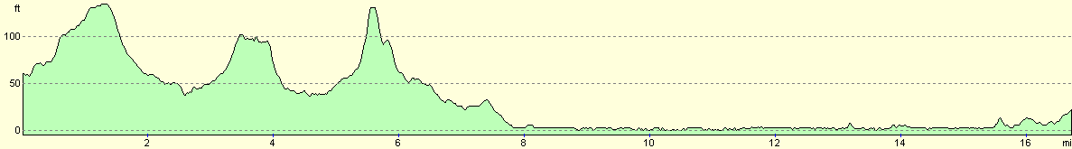
For more information on profiles, ascents and descents, see this page
Accommodation
We stayed at the Colchester Caravan and Camping park, Cymbeline Way, Lexden, Colchester, Essex CO3 4AG, at grid reference 968255. They have a website at www.colchestercamping.co.uk and can be contacted by phone on 01206 545551. This was probably the most complete site I have stayed on for some time, and was very professionally run, clean and tidy. It cost us twelve pounds per night for our pitch, which was very good value.
Disclaimer
Please note that I take no responsibility for anything that may happen when following these directions. If you intend to follow this route, then please use the relevant maps and check the route out before you go out. As always when walking, use common sense and you should be fine.
If you find any information on any of these routes that is inaccurate, or you wish to add anything, then please email me.
All images on this site are © of the author. Any reproduction, retransmissions, or republication of all or part of any document found on this site is expressly prohibited, unless the author has explicitly granted its prior written consent to so reproduce, retransmit, or republish the material. All other rights reserved.
Although this site includes links providing convenient direct access to other Internet sites, I do not endorse, approve, certify or make warranties or representations as to the accuracy of the information on these sites.
And finally, enjoy your walking!
This walk was mentioned in the following routes:
| My walk around the coastline of Britain |
Nearby walks
| # | Title | Walk length (miles) |
|---|---|---|
| 269 | Clacton-on-Sea to Brightlingsea | 18.8 |
| 270 | Brightlingsea to Fingringhoe | 15.2 |
| 272 | Tollesbury to Maldon | 17.2 |
|
|

|