Walk #490: Fort William to Camusnagaul
 |
 |
|
General Data
| Date Walked | 04/07/2003 |
| County | Highlands |
| Start Location | Fort William Railway Station |
| End Location | Camusnagaul |
| Start time | 10.04 |
| End time | 18.07 |
| Distance | 22.4 miles |
| Description | This was a nice walk along roads around Loch Eil, with some lovely views up and down the loch. |
| Pack | Today I wore Sam's bumbag with just a water bottle and spare batteries in it, so that I could give me shoulders a good rest. |
| Condition | The biggest problem that I had today was with my stomach, which has been unsettled all day. Wearing the bumbag put more pressure on it and did not help, and there were not many handy toilets on the walk. Later on my right shoulder also started aching, despite the fact that I did not have my rucksack on. Both calves were also aching early on after the exertions of yesterdays walk, but all these injuries could not have been too bad as I managed to walk a good distance today. |
| Weather | Today was another mainly sunny day, with only a few clouds to spoil it. Despite this it did not get too hot, perhaps as a result of the quite strong wind. |
| OS map | Landranger number 41 (Ben Nevis, Fort William & Glen Coe) and Landranger number 40 (Mallaig & Glenfinnan, Loch Shiel) |
 |
 |
|
 |
 |
|
Map of the walk
Maps courtesy of Google Maps. Route for indicative purposes only, and may have been plotted after the walk. Please let me have comments on what you think of this new format. For a detailed table of timings for this walk, please see the table file.
 |
 |
|
Notes
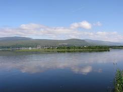
Sam and I went for a quick walk around Fort William this morning, to visit a couple of the walking shops and buy a few bits and bobs. This meant that I set off a little later than I wanted, but as the day was so glorious I really did not mind. I have done the first part of this walk along the northern bank of Loch Eil before, but I decided to take a different route to Corpach - instead of following the main road I would follow the first few miles of the Great Glen Way to the end of the Caledonian Canal. Unfortunately I found it very hard to find the way through Fort William, and it took me some time to find the bridge that leads over the River Nevis. Eventually I found my way through the housing estate (I had walked straight past the bridge without seeing it!) and joined the path as it headed beside the loch to Inverlochy Castle.
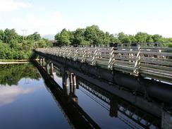
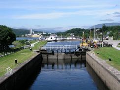
The Caledonian Canal is quite impressive, and I crossed it at the second loch from the sea at Corpach. The area was bustling with activity, and the water glinted and made a great contrast to Ben Nevis behind it. The canal runs all the way to Inverness, and although it is busy nowadays with pleasure traffic it did not have a long working life as the size of ships soon outgrew the size of it's locks. I followed much of it on a walk last year to Cape Wrath, and it made for a beautiful walk.
I got quite melancholic as I walked along the A830(T). I had walked along the road last year on the previous trip, and the day afterwards I had a little incident that could have been very serious and caused me to change all my plans. Everything came out all right in the end, but as I walked along the road I found that my mind kept on going back to that walk. Today I was only wearing a bumbag, but last year I had walked along the road with a full forty-five pound rucksack on - a vast difference in packs.
I met Sam at the junction of the A830(T) and the A861 road, and I went into Mervan for a quick lunch. We had a nice chat, but I was starting to feel a bit off colour and I was keen to continue. There is a range of hills that I have to go over in a couple of days, and as I want to do it at the start of the day I planned the next couple of walks so that I finish tomorrow's walk at the correct place. I really had to get a long day done today, but as the afternoon wore on I found the walk increasingly harder.
Sam phoned me as I was walking along the road on the south side of Loch Eil to tell me that she had a flat tyre on Mervan. She was parked at the Glenfinnan Monument, and she had tried to replace it herself but she could not get the spare tyre out from where it is stored under the van - I find it hard enough to do myself. She called the AA out, but they were going to be a long time and a nice gent did it for her, which was exceedingly kind of him. I got quite bored on this long road walk, and as the sun was behind me I started doing shadow puppets on the road before me. I created animals with both hands, and had them hiding behind the shadow of my hat before having them fighting. It is quite strange to admit this, but it was actually quite an enjoyable way of wasting a quarter of an hour.
Towards the end of the day I found it quite hard to walk as my stomach was feeling really upset. There were no toilets to be found anywhere, so I was forced to walk on. Sam passed me near the school at Achaphubuil, and I finally met her at the jetty at Camusnagaul. I went into the van and dropped off my gear, and almost immediately went to the toilet and sat on it for five minutes - not a pleasant experience. I can only hope that this gets better before tomorrow, as I do not fancy doing another walk feeling like I did this afternoon.
Directions
This walk sets off from For William Station. The initial part of it, as far as the Caledonian Canal, follows the Great Glen Way past Inverlochy. Set off from the station and turn right to head towards Inverlochy Castle. The path passes a supermarket and a sports complex before reaching a bridge over the River Nevis at its mouth. On the northern side of the river a path heads northeastwards beside the loch until Inverlochy Castle and the Soldiers Bridge, which is adjacent to the rail bridge and carries the footpath over the River Lochy. On the other side of the river turn left and climb up onto the B8006 road; from here the Great Glen Way is well signposted as it heads along the road before turning to the left to meet the side of the loch in Caol. The path eventually meets the Caledonian Canal in Corpach; cross the canal at one of the locks and head down the road, passing Corpach Station before meeting the A830(T).
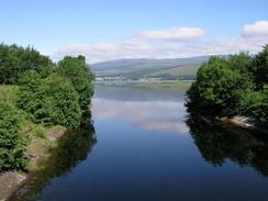
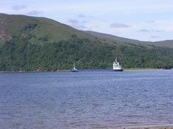
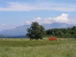
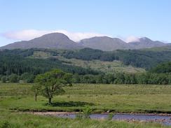
Turn left and walk westwards down the A830(T). This passes Loch Eil (Outwards Bound) Station and Locheilside Station before a junction with the A861 road is met beyond the head of the loch. Turn to the left and follow the A861 as it passes under a rail bridge and then goes eastward along the southern bank of Loch Eil for may miles. The road is very quiet, the views ahead are superb and this part of the walk was far better than I had any right to expect. Eventually the road passes the school at Achaphubuil and then rounds the corner to head south to the ferry jetty at Camusnagaul. If you want to make this a circular walk, then the ferry can be used to get back across Loch Linnhe to Fort William, because although the walk is over twenty miles long it has ended only a mile away from where it started, with only the loch in between.
Distances
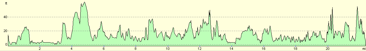
| From | To | Distance (m) | Ascent (ft) | Descent (ft) |
|---|---|---|---|---|
| Fort William Station | Corpach | 3.4 | 85 | 92 |
| Corpach | Drumsallie | 9.0 | 440 | 420 |
| Drumsallie | Camusnagaul | 10.0 | 650 | 676 |
This makes a total distance of 22.4 miles, with 1175 feet of ascent and 1188 feet of descent.
For more information on profiles, ascents and descents, see this page
Accommodation
We parked Mervan in a little car park by the ferry jetty in Camusnagaul. There were no facilities nearby, but we did not really need anything.
Disclaimer
Please note that I take no responsibility for anything that may happen when following these directions. If you intend to follow this route, then please use the relevant maps and check the route out before you go out. As always when walking, use common sense and you should be fine.
If you find any information on any of these routes that is inaccurate, or you wish to add anything, then please email me.
All images on this site are © of the author. Any reproduction, retransmissions, or republication of all or part of any document found on this site is expressly prohibited, unless the author has explicitly granted its prior written consent to so reproduce, retransmit, or republish the material. All other rights reserved.
Although this site includes links providing convenient direct access to other Internet sites, I do not endorse, approve, certify or make warranties or representations as to the accuracy of the information on these sites.
And finally, enjoy your walking!
This walk was mentioned in the following routes:
| My walk around the coastline of Britain |
Nearby walks
| # | Title | Walk length (miles) |
|---|---|---|
| 153 | Kinlochleven to Fort William | 14.1 |
| 154 | Ben Nevis from Fort William | 11.8 |
| 185 | Fort William to Glenfinnan | 15.2 |
|
|

|