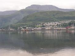
Walk #491: Camusnagaul to Inversanda
 |
 |
|
General Data
| Date Walked | 05/07/2003 |
| County | Highlands |
| Start Location | Camusnagaul |
| End Location | Inversanda |
| Start time | 09.36 |
| End time | 15.30 |
| Distance | 17.0 miles |
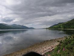
| Description | This was a long road walk along quiet roads, but it was quite enjoyable nonetheless, with some lovely views available over Loch Linnhe. |
| Pack | Today I wore Sam's bumbag with just a water bottle and spare batteries in it, so that I could give me shoulders a good rest. |
| Condition | Yet again I have had significant troubles today, the worst of which was my stomach that is significantly unsettled. Both of my claves also ached more than they did yesterday, and my neck and right shoulder also hurt at times. I feel as though I am falling to pieces! |
| Weather | Today was the cloudiest day for some time, although this did not turn itself into rain. There were some sunny periods, however, and it never got cold enough for me to put a fleece on over my t-shirt, despite a fairly stiff wind. |
| OS map | Landranger number 41 (Ben Nevis, Fort William & Glen Coe), Landranger number 40 (Mallaig & Glenfinnan, Loch Shiel) and Landranger number 49 (Oban & East Mull) |
 |
 |
|
 |
 |
|
Map of the walk
Maps courtesy of Google Maps. Route for indicative purposes only, and may have been plotted after the walk. Please let me have comments on what you think of this new format. For a detailed table of timings for this walk, please see the table file.
Notes
I met Sam for lunch at the Ardgour Hotel, and I could hardly wait to get there. For the last couple of miles my stomach had been doing somersaults, and I was desperately in need of the toilet. Sam met me a few hundred yards from the hotel, and when we entered it Sam went to order some drinks (orange and lemonade for me, I firmly knew that alcohol would not do my dodgy constitution any good!) and I used the opportunity to go to the toilet. Afterwards I felt much worse, and I was extremely tempted to stop the walk then, after only ten miles. I am a fairly stubborn bloke, however, and I knew that I would feel bad if I did such a small mileage. Outside the pub there were a few people, and they gave us some nice donations and we had a long chat. One gentleman in particular was born in an area of Staffordshire that I knew well, was brought up in South Devon near the place that we own some land, and he has worked in the complex where the Riding for the Disabled Association is based!
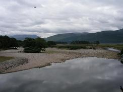
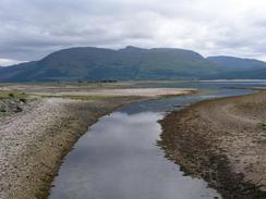
It was a nice chat, but I was feeling faint and wanted to get on whilst I could, as I was hoping that I would feel better once I started walking. The Loch at Corran is only half a kilometre wide, and yet I have walked over forty miles to get here via Fort William (and over fifty if you count my ascent of Ben Nevis). As we sat outside the pub I enjoyed watching the ferry ply to and from across the Corran Narrows, disgorging its contents and taking on new cars. The church in the village is quite tiny, and was one of a series designed by Telford in the early nineteenth century. They were sponsored by the government in a failed bid to create local employment, and I examined another of these churches, at Croich in the highlands, on a previous trip.
I had intended to walk a long way today, as I wanted to reach Kingairloch today. Unfortunately this was not to be, but I still managed quite a reasonable distance - over sixteen miles, the average that I had planned to do when I started the trip. It is a good sign that I now see sixteen miles a being a 'short' day, and twenty miles as being a 'good' day. Unfortunately I was feeling so ill by the time that I reached the junction between the A861 and B8043 at Inversanda I was glad of a rest, so I piled into Mervan and we drove to the campsite. I am quite glad that I have a campsite tonight, as it has allowed me to have a hot and luxuriously long shower, and also use the computer, which has taken my mind off my stomach pains somewhat. Sam bought some Imodium, and this seems to have helped more than a bit as well. The hot shower also helped to reduce the pain in my neck and shoulder slightly, which is more than a little useful and allowed me to relax in Mervan easier afterwards.
Wearing this bumbag is starting to get on my nerves - my shoulder has not stopped hurting me now that I am not wearing my rucksack. This is extremely worrying, as I had hoped that the pain would stop once I started walking with no load on my shoulders. The bumbag puts pressure onto my stomach, which is not a good thing the way it is feeling currently. I think that I shall wear my rucksack for the next day's walk, as this will allow me to carry all my kit without the irritation of using the bumbag. It will also allow me to see if my shoulder is any better, although I very much doubt that it will be as it has not really improved so far. It is getting to the stage where if it continues like this for another couple of weeks then I shall be forced to go to a doctor again to see what they say about it. Before I set off on the walk I was expecting to get an injury or two on the trip, as 5,500 miles is an extremely long way to walk with no problems. However I would not have guessed that the biggest problem that I would have would be with my neck and shoulder - my feet, ankles and legs were much more likely to have been injured.
I think that I will take tomorrow off, as I am feeling so bad today and a rest could do me good. As usual I am loath to take a day off, but this is probably the best thing to do as I am suffering from three problems; my stomach, my calves and, most worryingly, my right shoulder, which is still nowhere near right. I also have to decide the route that I take for the next day's walk; I had intended to go cross-country to Glensanda, but as I did not reach Kingairloch this will be a long walk to complete it in a day, especially as I am not exactly operating at one hundred percent. For this reason it will probably be best if I stick to the road, a fact that I am spitting blood about as I really would not mind doing the path down to Glensanda. I hate having to alter my route in such a way but I have to be pragmatic - there is no point doing something that may stop me from finishing the entire walk now that the end is so near.
Today has also been one of the few days on the trip when I have actually asked myself why I am doing this crazy thing, and whether I will be able to finish. Such negativity is never a good thing on a long distance walk, as confidence is a prerequisite in my opinion, but when you are feeling like I did today some self-doubt must be inevitable and, in a way, a good thing. As I am now eighty percent of the way through the walk I am more than a little determined to continue on and will change my route if I have to rather than abandon the walk. For instance if it turns out that I cannot carry a pack with full camping gear in due to my shoulder injury, then I shall have to alter my route so that it involves n camping. This will mainly involve altering my plans for two areas; Knoydart is going to be tricky, but Cape Wrath I could manage by using the bothy at Keravaig.
Directions
This walk starts off at the ferry jetty at Camusnagaul, across Loch Linnhe from Fort William. The directions for the walk are very simple; simply follow the A861 road southwestwards along the western bank of Loch Linnhe as it passes through Corran. The walk ends at the junction with the B8043 road in Inversanda.
Distances
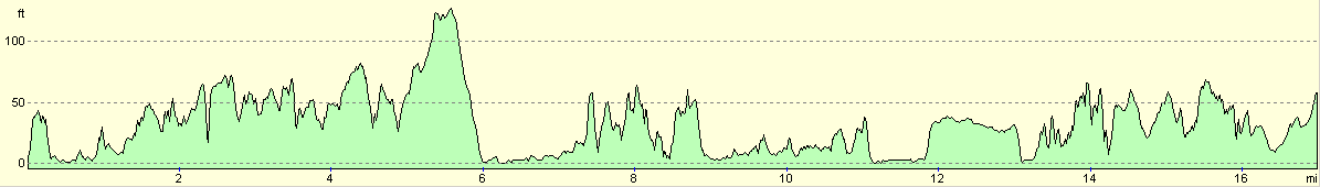
| From | To | Distance (m) | Ascent (ft) | Descent (ft) |
|---|---|---|---|---|
| Camusnagaul | Ardgour | 10.5 | 1014 | 1001 |
| Ardgour | Inversanda | 6.5 | 499 | 463 |
This makes a total distance of 17.0 miles, with 1513 feet of ascent and 1464 feet of descent.
For more information on profiles, ascents and descents, see this page
Accommodation
We spent the night at the Glenview Caravan Park, Strontian, Acharacle, Argyll, Highlands PH36 4JD. This site was nice, and the showers were fortunately piping hot. They can be contacted on (01967) 402123, and the site costs £11.50 per night (we stayed two nights at the site, and they gave us a reduction for the fist night so it only cost us £6, which was kind of them).
Disclaimer
Please note that I take no responsibility for anything that may happen when following these directions. If you intend to follow this route, then please use the relevant maps and check the route out before you go out. As always when walking, use common sense and you should be fine.
If you find any information on any of these routes that is inaccurate, or you wish to add anything, then please email me.
All images on this site are © of the author. Any reproduction, retransmissions, or republication of all or part of any document found on this site is expressly prohibited, unless the author has explicitly granted its prior written consent to so reproduce, retransmit, or republish the material. All other rights reserved.
Although this site includes links providing convenient direct access to other Internet sites, I do not endorse, approve, certify or make warranties or representations as to the accuracy of the information on these sites.
And finally, enjoy your walking!
This walk was mentioned in the following routes:
| My walk around the coastline of Britain |
Nearby walks
| # | Title | Walk length (miles) |
|---|---|---|
| 153 | Kinlochleven to Fort William | 14.1 |
| 154 | Ben Nevis from Fort William | 11.8 |
| 185 | Fort William to Glenfinnan | 15.2 |
|
|

|