Walk #154: Ben Nevis from Fort William
 |
 |
|
General Data
| Date Walked | 25/08/2001 |
| County | Highlands |
| Start Location | Glen Nevis Visitor Center |
| End Location | Fort William Railway Station |
| Start time | 08.40 |
| End time | 16.55 |
| Distance | 11.8 miles |
| Description | A walk up Britain's highest mountain, followed by a short walk back into Fort William. |
| Pack | My Karrimor 30-litre rucsack with fleece, coat and medical bag. |
| Condition | I feel fine considering the difficulty of the walk that I have just completed. This is shown by the fact that I felt fit enough after descending from the top of Ben Nevis to walk two miles back to Fort William. Indeed I felt far fitter at the end of today's walk than I did when walking into Fort William after yesterday's walk. I got slightly out of breath on the initial part of the ascent, but once the Lochan had been reached I felt much better and managed to make good time up the zig-zags to the summit. |
| Weather | At lower levels the weather was mainly a mixture of sunshine and light clouds with scarcely any wind. As the day went on the sunny periods got longer and the cloud level slowly rose. As height was gained I started to pass through some wispy clouds, and the summit was covered in cloud but with occasional breaks allowing some lovely views to be seen. At the top of the mountain it was quite cold, but as I started to descend it slowly got hotter. |
| OS map | Landranger number 41 (Ben Nevis, Fort William & Glen Coe) or Outdoor Leisure number 38 (Ben Nevis & Glen Coe) |
 |
 |
|
Map of the walk
Maps courtesy of Google Maps. Route for indicative purposes only, and may have been plotted after the walk. Please let me have comments on what you think of this new format. For a detailed table of timings for this walk, please see the table file.
Notes
Wow! What an absolutely stupendous way to finish a holiday! Yesterday I had been quite depressed having finished the last leg of the walk on this trip, but today has more than made up for it.
I started the day off by catching the 08.25 bus from the bus station in Fort William down Glen Nevis to the Ben Nevis Visitors Center. When I got there I prepared myself for a few minutes before setting off, only to find that the last leg of a National Three Peaks race was going on, with the weary leaders making their way down the mountain. I chatted to a few people for a short while and discovered that some people had started up the mountain at two that morning! I dread to think how difficult running up the path must be in daylight, yet along in the dark. The stream of people coming down the path was like the M1 in places, and I often had to stop to let people pass me as they came down.
In places the path up the mountain was nothing but rough boulders which made the going very hard. In particular I found the descent very hard on my ankles, which explains the relatively long time it took me to get down. My walking poles were in use the whole time, and they helped me keep my balance on the stoney surface.
It was truly a great feeling to reach the summit, especially as I had not intended to do it on this trip. I have now completed the highest of all the county tops and connected it to my LEJOG walk. Although Ben McDui, the second highest county top, is only a little lower than Ben Nevis, at least I know that I have the fitness to do high mountains eleven years after I last did any Munros.
After I finished my walk yesterday I went to my B&B and had a shower before heading into town to buy myself a small rucksack for this walk. I did this because I did not want to carry my 70-litre rucksack up the hill. In the end I bought a 30-litre Karrimor Hotrock 30, which proved to be absolutely fine for this walk.
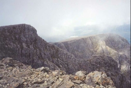
The top of the mountain was mostly wreathed in cloud whilst I was up there, although at times the cloud lifted to reveal some lovely views. At these times the mass of people tended to shift around to whichever side of the mountain the view was visible from.
On the summit is the remains of the old meteorological station, built by Public subscription and opened on the 17th of October 1883. It was manned throughout the year by a superintendant and two assistants and provided meteorological observations every hour for 20 years. It is now ruined, but enough remains to make you admire the hardy people for whom this was home. It finally closed on October 1st 1904 after the funds to run it ran out, and over the years it slowly fell into disrepair.
There were various sorts of people making their way up the mountain. As I was just starting the descent an eight year old boy with hismother were approaching the summit, which certainly put my climb in the shade. There were also people walkng up who were bareback, which must have been very cold indeed as I had to put my coat on near the summit due to the temperature decreasing.
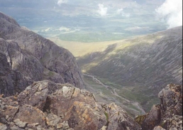
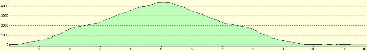
The halfway point of the climb is at the waterfall at Red Burn, at 2,230 feet above sea level, and this marks the start of a more difficult stage of the climb. The waterfall itself is very picturesque, and on the way down it was covered in people climbing around it. Beyond this the track climbs up the north west shoulder of the mountain in a series of four large zig zags, before flattening out and climbing over McLean's Steep to the summit.
If you think that reaching the top of Ben Nevis is an achievement, it is. I was quite proud of conquering my first Munro for 11 years, but I wish I had got a faster time. If you want a real achievement, however, then look no further than Mr. Kenneth Stuart, who made it to the top and back down again in a remarkable 1 hour, 25 minutes and 34 seconds during a Ben Nevis race. The ladies time is an equally impressive 1 hour, 43 minutes and 25 seconds, by Pauline Haworth. Comsidering that this is a quarter of my time I think that I can honestly say that there is no hope of me beating it - but who would want to? Surely racing up and down hills like this stops you from being able to view the glorious scenery?
Directions
This walk starts in the car park of the Ben Nevis Visitors Center, situated in Glen Nevis at NN 1220 7295. Go through the car park until you meet the River Nevis, and then turn left to follow the western bank of the river northwards to the end of the car park. Here a footbridge crries you over to the eastern bank of the river.
On the eastern bank of the river a footpath leads southwards for a short distance, before it turns to the left and heads eastwards for a short distance through the grounds of Achintree House. A stile leads across from the path to meet the end of a road. Turn right at the road and join the Neb Nevis Mountain Track (which was previously called the Ben Nevis Tourist Route) as it heads soithwards. As it does so it starts to rise from 30 metres above sea level at the road to 150 metres at NN 1320 7215, where the path leading up from the Youth Hostel in Glen Nevis meets the Mountain Track.
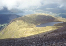
The track continues to rise as it skirts the western side of Meall an t-Suidhe, zig-zagging twice and crossing a couple of streams by means of a couple of funky small metal bridges to reach 350 metres above sea level. The tradck then starts to veer northwards, following the western bank of the Red Burn Gully. Another, larger zig-zag takes you up to the saddle between Ben Nevis to the east and Meall ant-Suidhe to the west at 570 metres above sea level.
The track passes to the east of Lochan Meall an t-Suidhe that lies in the saddle. It then turns to the right to start the ascent up the western side of Ben Nevis. At NN 1473 7186 the track crosses the Red Burn under a waterfall, and this marks the halfway point of the ascent, at 600 metres above sea level.
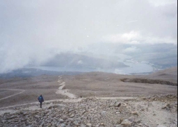
From the Red Burn the track continues up the north-western shoulder of Ben Nevis in a series of four giant zig-zags. Thse bring you out at the 1,200 metre level, and the gradient of the track starts to flatten out as it heads in a westwards directon. One last, but thankfully short, ascent of McLean's Steep leads to the summit plateau. Across here carful navigation is needed to reach the summit cairn at 1,344 metres above sea level. The summut plateau is bounded on the northeastern side by some very steep drops, including Tower Gully and Gardyloo Gully which the path runs adjacent to. Be careful to avoid these gullies, particularly in winter when cornices may have formed over the edge.
To reutrn from the top, continue down on the same route that you came up. There are other routes down the Ben which can be used if you are an experienced climber in good weather, including one along the Carn Mor Dearg Arete to Carn Mor Dearg and Carn Beag Dearg.
When you reach the visitor centre in Ben Nevis once more leave the car park and join the road. This leads northwards along Glen Nevis for about a mile and a half to the roundabout at Nevis Bridge. Go straight on at the roundabout and follow the road for half a mile into the town centre. The railway station is immediately to the right at the roundabout.
Distances
| From | To | Distance (m) | Ascent (ft) | Descent (ft) |
|---|---|---|---|---|
| Ben Nevis Visitors Center | Summit of Ben Nevis | 5.1 | 4409 | 112 |
| Summit of Ben Nevis | Ben Nevis Visitors Center | 4.9 | 112 | 4409 |
| Ben Nevis Visitors Center | Fort William Railway Station | 1.8 | 131 | 167 |
This makes a total distance of 11.8 miles, with 4652 feet of ascent and 4688 feet of descent.
For more information on profiles, ascents and descents, see this page
Accommodation
I stayed in a B&B in Alma Road, right above the centre of the town and not far from the railway station. I think that the number of the house was number 60, but memory fails me. It is a shame as it was a very nice place, and I would like to be able to recomend it.
Disclaimer
Please note that I take no responsibility for anything that may happen when following these directions. If you intend to follow this route, then please use the relevant maps and check the route out before you go out. As always when walking, use common sense and you should be fine.
If you find any information on any of these routes that is inaccurate, or you wish to add anything, then please email me.
All images on this site are © of the author. Any reproduction, retransmissions, or republication of all or part of any document found on this site is expressly prohibited, unless the author has explicitly granted its prior written consent to so reproduce, retransmit, or republish the material. All other rights reserved.
Although this site includes links providing convenient direct access to other Internet sites, I do not endorse, approve, certify or make warranties or representations as to the accuracy of the information on these sites.
And finally, enjoy your walking!
Nearby walks
| # | Title | Walk length (miles) |
|---|---|---|
| 152 | Kings House Hotel to Kinlochleven | 8.7 |
| 153 | Kinlochleven to Fort William | 14.1 |
| 185 | Fort William to Glenfinnan | 15.2 |
|
|

|