Walk #155: Caister-on-Sea to Sea Palling
 |
 |
|
General Data
| Date Walked | 08/09/2001 |
| County | Norfolk |
| Start Location | Caister-on-Sea lifeboat station |
| End Location | Sea Palling lifeboat station |
| Start time | 09.05 |
| End time | 13.43 |
| Distance | 12.5 miles |
| Description | This was a pleasant walk following the Norfolk coast, using both the beach and the clifftop paths. |
| Pack | Today I carried my Karrimor 30-litre rucksack with coat, trainers, medical bag and some extra clothes. |
| Condition | I am feeling reasonably okay after this walk. The underside of my right foot hurts but not my left one, which is highly unusual. My left ankle also ached for some periods, although it was never so bad that I started worrying about it. |
| Weather | The weather today was very varid. It started off with some rain, and a combination of sunshine, cloudy periods and showers followed me for the first hour or so. After this it brightened up slightly, although thw wind started to pick up ntil at the end of the day it was quite ferocious, and as it was coming from the northwest it was a headwind. Fortunately the wind was not very cold, so it did not chill me at all. |
| OS map | Landranger number 134 (Norwich & The Broads, Great Yarmouth) |
Map of the walk
Maps courtesy of Google Maps. Route for indicative purposes only, and may have been plotted after the walk. Please let me have comments on what you think of this new format. For a detailed table of timings for this walk, please see the table file.
 |
Notes
The item most worthy of note about today's walk was the wind, which at times was extremely fierce, particularly when I was walking along the beach towards the end. The wind made the going very hard as it was a headwind and a times I felt like I was not making any progress against it. I looked on with envy at the people who were walking in the opposite direction; on the least section of the walk I did not see anyone walking in the same direction as myself; I guess that they all had more sense.
I am slightly annoyed that I felt tired at the end of this walk as I should not have found it too strenuous; there were no hills to climb and I did not have a heavy pack. I put down my feeling of fatigue to the fact I spent long periods walking along beaches, which always seems to tire me out and make various parts of my body hurt. Certainly on a few occasions when I left the beach and hit tarmac of firmer ground my pace would instantly increase as my feet got better purchase.
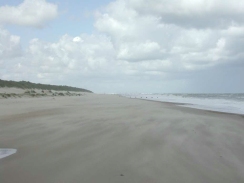
Some of the beaches were very picturesque, and in particular the one between Warren farm and Sea Palling was very nice. It was also almost deserted, and I did not see anyone for half-an-hour until I got nearer to Sea Palling. The walk was slightly spoiled by the high winds, but this gave great views of a stormy sea - the white of the wave tops; the grey of the deep sea and the lighter grey of the sea nearer shore. It also led to my getting shot-blasted by sand on a couple of occasions when sand had been picked up as far as head height and was being blown into me. A more common occurrence was shifting shapes over the surface of the sand as dry sand blew along in the wind. This effect was quite mesmerising, and I ended up looking down at it as I walked on. Where the waves were breaking they were sometimes leaving deposits of foam, and the wind was also blowing these across the surface of the sand. And thus a lovely duet of foam and sand kept me occupied as I walked. All I needed was a nice bit of Bach in the background and the effect would have been perfect, but unfortunately the rushing sound of the wind was not very musical.
I was going to attempt to walk along the beach the whole way if at all possible, but almost immediately this proved to be impossible as it was high tide and the beach at Caister beside the lifeboat building seemed to narrow for my liking. Therefore I chose to do a combination of cliff top and beach walking, dropping down to the beach where possible and then gaining the cliff top paths again once progress proved impossible. Fortunately the cliffs were not very tall or steep, and there was only one occasion that I had to climb up or down them instead of using proper access points.
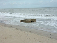
Near the Hemsby inshore lifeboat station was a second world war concrete bunkhouse embedded in the sand, with the sea crashing around it. This had obviously once been on the cliffs and had come down relatively recently in a cliff fall. The sight of one of the viewing slits being barely visible as it dipped at an angle into the water we fairly incongruous. Later on I came across the remains of a brick building - perhaps a beach top shop - that had fallen into the sea and was blocking what little beach there was. This too looked quite impressive as waves broke around it.
When I set out to do this walk, my main target was to reach Sea Palling, and I had got transport details from there. I had hoped that I may get further, perhaps as far as Happisburgh three or four miles further on, but the last bus was at 15.30, and it set off earlier than this from Happisburgh, so I had no chance of making Happisburgh before the bus left. I also did not fancy walking much further in the wind. As soon as I got away from the beach and sat down on a bench at Sea Palling to wait for the bus, the wind was much more manageable as I was being sheltered by the buildings and the dunes. This made the wait very pleasant, especially as I bought an ice cream to help me while away the time. When the bus did arrive there was a few funny minutes as the bus driver attempted to get into the bus turning/parking bay, as a van driver had parked right in the place he had to use to swing around (the van driver was on yellow lines). The bus driver eventually made it, but not before he had caused a mini traffic jam.
My next walk on my walk around East Anglia will probably be from Sea Palling to Mundesley, which should be about the same distance as today's walk. The route is less obvious however, and if I find that I cannot walk along the beach then there are few cliff top paths to go up onto. This should be a fairly easy walk, although transport between Mundesley and Sea Palling will be difficult. After that is it a short walk to get from Mundesley to Cromer, and fortunately there are good transport links between these two places.
Directions
The basic directions for this walk are simple; make your way up the coast keeping the sea to your right. Unfortunately due to high tides, and cliff collapses it is not quite that simple. Since I started this walk just before a high tide, certain sections of beach were unfortunately closed off to me. I started this walk at the car park beside the Caister lifeboat station. Note that this car park is very expensive to park in, so I parked in a nearby street.
Because the tide was in I left the lifeboat station and headed north through the car park to meet a road. Immediately opposite the entrance to the car park a road heads northwards. Follow this as it soon becomes unpaved and eventually a track as it skirts inland of the beach.
The track continues along the coast, following the line of an old railway line. Eventually it rises up on to the top of some small cliffs as it enters a caravan park on the souther edge of the village of California. The path continues to skirt the top of the cliffs until it reaches a small gate; unfortunately this was locked so I had to make my way to the exit of the caravan park and then turn right down the road. There are some toilets here and a shop, so it is useful if you want some supplies.
The road ends at the cliff, and a slope starts to lead down to the beach. Halfway down this slope some steps lead down from the right; these are the steps that lead from the locked gate at the end of the caravan park. Fortunately this gate did not lead to my having to make a long diversion. When the beach is reached turn left and follow it as it heads north-northwestwards.
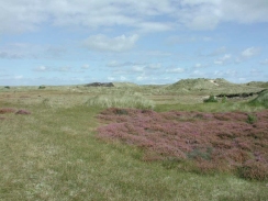
The beach skirts under California and then, with scarcely a break, under the village of Newport. Continue along the beach as far as Winterton-on-Sea, skirting between the sand dunes and the beach. In Winterton-on-Sea turn left and head up westwards to meet a road near a shop and a toilet block. Continue along this road to a junction. Continue straight up towards the church and take the first road that leads off to the right. Follow this road as it enters Winterton Dues Nature Reserve.
Head northwestwards through the nature reserve. The track is clear in places, but in other is less clear but as long as you roughly keep the border fence of the reserve to the left and the dunes to the right it will be fine. Near Winterton Ness the path leaves the nature reserve and joins a track as it skirts to the left-hand side of a large bank designed to keep the sea out. From the start of the sea bank the track continues on for three kilometres past the inaptly-named Bramble Hill (for I could not see a hill of any description) to meet a track leading in from the left just before Warren Farm is reached.
Turn right down the track and climb over the sea bank to join the beach. Turn left and follow the beach northwestwards for four kilometres until it meets another lifeboat station beside a road in Sea Palling. Turn left up this road and climb over the sea bank into Sea Palling. There is a pub to the right and some shops to the left, and the turning circle for buses and the bus stop is to the right just past the first road to the right.
Distances
| From | To | Distance (m) | Ascent (ft) | Descent (ft) |
|---|---|---|---|---|
| Caister-on-Sea | Winterton-on-Sea | 5.7 | 367 | 348 |
| Winterton-on-Sea | Sea Palling | 6.8 | 62 | 79 |
This makes a total distance of 12.5 miles, with 429 feet of ascent and 427 feet of descent.
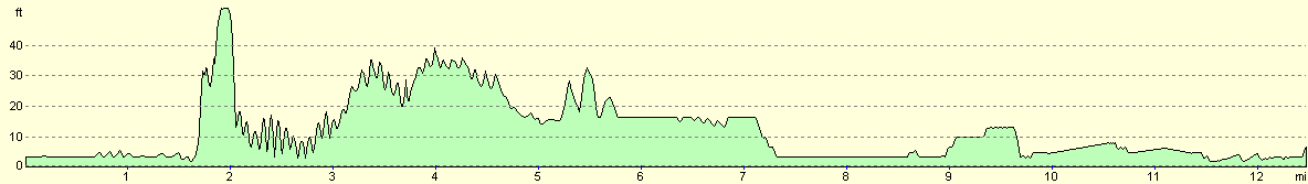
For more information on profiles, ascents and descents, see this page
Transport
A bus service runs occasionally from Sea Palling to the old railway station in Stalham. This service is Sanders Coach service Number 36, and runs from Mondays to Saturdays. The last bus from Sea Palling rund at 14.30, which is an early time to have to get there for. Another bus service runs from a bus stop on the main road in Stalham to Great Yarmouth via Caister-on-Sea. Note that this service does not run from the old railway station. To get to the bus sop on the main road turn left out of the bus stop at the old station and follow the road as it turns round to the left to meet the A149 road. Turn left down the road and the bus stop is a short distance ahead on the left.
Disclaimer
Please note that I take no responsibility for anything that may happen when following these directions. If you intend to follow this route, then please use the relevant maps and check the route out before you go out. As always when walking, use common sense and you should be fine.
If you find any information on any of these routes that is inaccurate, or you wish to add anything, then please email me.
All images on this site are © of the author. Any reproduction, retransmissions, or republication of all or part of any document found on this site is expressly prohibited, unless the author has explicitly granted its prior written consent to so reproduce, retransmit, or republish the material. All other rights reserved.
Although this site includes links providing convenient direct access to other Internet sites, I do not endorse, approve, certify or make warranties or representations as to the accuracy of the information on these sites.
And finally, enjoy your walking!
This walk was mentioned in the following routes:
| A walk around East Anglia |
Nearby walks
| # | Title | Walk length (miles) |
|---|---|---|
| 136 | Lowestoft to Caister-on-Sea | 14.4 |
| 163 | Sea Palling to Mundesley | 9.4 |
| 256 | Sheringham to Rudram's Gap | 15.1 |
|
|

|