Walk #156: Kings Lynn to Snettisham
 |
 |
|
General Data
| Date Walked | 09/09/2001 |
| County | Norfolk |
| Start Location | Kings Lynn Station |
| End Location | Snettisham |
| Start time | 09.00 |
| End time | 13.35 |
| Distance | 14.6 miles |
| Description | This was a nice walk along some good tracks, paralleling the eastern coast of the Wash. |
| Pack | Today I carried my Karrimor Hotrock 30 rucksack with my boots and medical kit in. |
| Condition | I feel generally okay after today's walk. The underside of my left foot hurts, as it did yesterday, and I think that I may have bruised it. My legs are slightly fatigued, and I had to stop my car at Ely on the journey back so that I could get out and stretch my right leg, as the underside of the knee had got stiff. My back is okay and I do not feel too fatigued, so I could probably have gone even furter today. |
| Weather | The main factor about today's weather was the wind, as it was yesterday. This was very strong, and when I was exposed on the top of floodbanks it was very noticeable. It was cloudy for most of the day, with the ocasional spell of sunshine to warm me up. It started to rain for a few minutes when I was at the bus stop waiting for the bus back to Kings Lynn, but it did not rain at all during the actaul walk. If it had not been for the wnd then it would have been near perfect walking weather. |
| OS map | Landranger number 132 (North West Norfolk, King's Lynn & Fakenham) |
Map of the walk
Maps courtesy of Google Maps. Route for indicative purposes only, and may have been plotted after the walk. Please let me have comments on what you think of this new format. For a detailed table of timings for this walk, please see the table file.
Notes
The first thing to note about today's walk is that the majority of it was along farm tracks that are not unnecessarily public rights of way, so I cannot say for sure that this walk does not involve trespass. I am on tracks at all times, however, and am not cutting cross-country so I feel that it is not too bad. I was also passed by a couple of vehicles which did not bat an eyelid at my presence.
My initial plan was to go out and investigate following the banking that goes from the northern end of the River Great Ouse and heads along the eastern side of the wash. This banking has a track on top of it and would have proved to be a great way to get to Hunstanton, but unfortunately a 'no access' sign stopped me from reaching the start of the track, which was a shame. The sign mentioned shooting, which firmly made my think that progressing along the track past the sign was not a good idea.
Fortunately there was a public footpath that went to the east from the sign, and so I followed this for a short distance until it came to a track. I was now faced with a decision; I could go back to Kings Lynn via the footpath, or I could go on along the track. The Ordnance Survey map showed no right of way, but neither were there any signs telling me to keep out. So with some trepidation I set out along the track, thinking up excuses to make if someone challenged me. Fortunately this never happened, and indeed I hardly saw anyone for the entire walk from when I left the dockside area in Kings Lynn until I got to the outskirts of Snettisham.
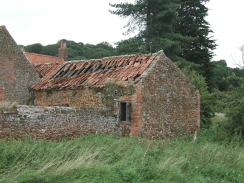
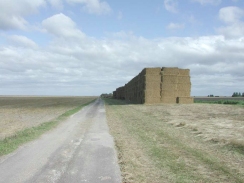
Today's walk followed roads or tracks for the entire distance, and hence the going was generally good. I wore my cross-trainers, which is probably the main reason why my feet do not hurt as much as they did yesterday. The surface of the track varied enormously; one minute it was concrete, and next would be a grassy section followed by a rough stone surface. A large section even comprised of nothing but crushed sea shells, which had obviously recently been laid down as there were few plants growing through them and there were large piles of half-broken shells at the sides of the track where wheels had thrown them. I cannot recall having seen this surface before, but it made an excellent surface along which I could make some very good time. I wonder how the farmer gets hold of so many shells; although there are plenty of beaches nearby the sheer tonnage needed to surface such long sections of track must be very large indeed. Later on I came across another section that had the same surface except this one was much older as the shells were much more finely crushed and the middle of the track was a verdant green with weeds growing though it.
The initial part of the walk following the eastern bank of the Great Ouse northwards was quite nice once the factories and the docks had been left behind, with a view into the Wash being available in the distance. The river was also very high, right near the top of the flood defences. At one point near the docks the water was only about six feet away from where I was standing, although at that point there could well have been some other defences further inland. This showed me exactly how great the tidal range of the estuary is, as I have seen the water level a good twenty or thirty feet lower in the past further up in the town center.
When I reached the road at Shepherd's Point I felt as if I could have walked on and got as far as Hunstanton, but I did not for two reasons; firstly although I still felt fit I had a couple of nagging pains, and secondly I did not fancy having to face the wind on the exposed sea banking. I therefore chose to cut across to Snettisham, where I hoped that the bus that called at Dersingham would also call. I had only got the time for the bus from Dersingham, and it was due to get there at 42 minutes past every hour. I reckoned that the bus would take seven or eight minutes to get from Shettisham to Darsingham, so I reckoned that I would have to get the bus stop at about 13.34, and I managed to get to the bus stop and buy a paper in the adjacent shop just before it arrived. Yet again I have had a journey where I have been able to make a lucky transport connection.
I am now left with a fairly simple five mile walk to get to Old Hunstanton if I were to follow the road. I think to make things more interesting (and to make it a longer walk) I will walk back from Snettisham towards the sea at Sherpherd's Point, and then use public footpaths that skirt the sea to get into Hunstanton. This will increase the length of the walk, but should make it more interesting.
Directions
This walk starts off at the railway station in Kings's Lynn, where there is plenty of parking available. Turn left out of the station car park and then immediately right, to go down Waterloo Street. Cross over the A1078 roads and head straight on down Old Market Street. When this ends make your way through a small shopping centre to New Conduit Street, which can be followed westwards for a short distance. When New Conduit Street ends continue along Purfleet Street, at the end of which is the King's Lynn Tourist Information Office.
Turn left out of the Tourist Information office to head north up King Street. When this ends at a large square follow Tuesday Place and then St Nichol Street. At the end of St Nichol Street turn half-left down St Ann's Street and follow this around to the right as it becomes North Street. When this ends at a junction with the A1078 road turn left and follow it until it bends sharply to the right. Go straight on to head west through a gateway into the port and head down Bank Road.
Head south-northwestwards along Bank Road and past the fishing dock. When the road turns to the right to head north-northwestwards follow it as it skirts past a series of chemical factories to the right and the River Great Ouse to the left. The road passes under some power lines before it turns sharply to the right just over two kilometres after the docks.
The road becomes a track running along the top of a floodbank until it turns sharply to the left again at TF 6072 2307. Here a sign forbids access along the floodbanks, but fortunately a path drops down the bank to the right. Take this footpath for a short distance southeastwards until another track is reached.
Turn left along this track and follow it to a farm building in the South Outmarsh. At a junction turn left to head directly northwards for a kilometre to a left-hand bend which leads in a short distance to a bridge over a drainage channel. Cross this bridge and head north-northeastwards along another track and between some farm buildings. At another junction at TF 615 251 head northwards along another track for a little under a kilometre.
This track curves around to the right for a short distance as a track heads in from the left. Follow the track as it bends around before taking a near-northerly course once more. The track rises up onto the flood banking once again near a farm building at yet another junction in the tracks. Continue straight on down off the floodbank to head north-northeastwards once more.
The track continues on for a little over two kilometres until it reaches another junction in the tracks at TF647290. From here take the track that heads north-eastwards to meet another track and a couple of buildings at TF 654 303. From here take the track that heads on north-northeastwards for a kilometre until this ends at a T-junction. Turn right for a short distance and then a couple of hundred metres later turn left to head northwards once more.
After just under two kilometres this track meets a drainage channel and turns to the right to skirt its southern edge. After a couple of hundred metres the track turns to the left and becomes a surfaced road, and this ends at a T-junction with the Snettisham to Shepherd's Port road.
Turn right down this road and follow it as it heads eastwards past Locke Farm to meet the A149 road. Cross the A49 road and turn left along the pavement for a short distance to a road junction on the right. Go down this road for a kilometre eastwards until it ends in a T-junction with the B1040 road in Snettisham. Turn left down this road and follow it northwards for about 700 metres to a bus stop on the right-hand side of the road. This is the bus stop for bus services back to King's Lynn.
Distances
| From | To | Distance (m) | Ascent (ft) | Descent (ft) |
|---|---|---|---|---|
| Kings Lynn | TF 6148 2516 | 5.0 | 72 | 79 |
| TF 6148 2516 | Road at Shepherd's Port | 7.1 | 23 | 20 |
| Road at Shepherd's Port | Snettisham | 2.2 | 59 | 16 |
This makes a total distance of 14.3 miles, with 154 feet of ascent and 115 feet of descent.
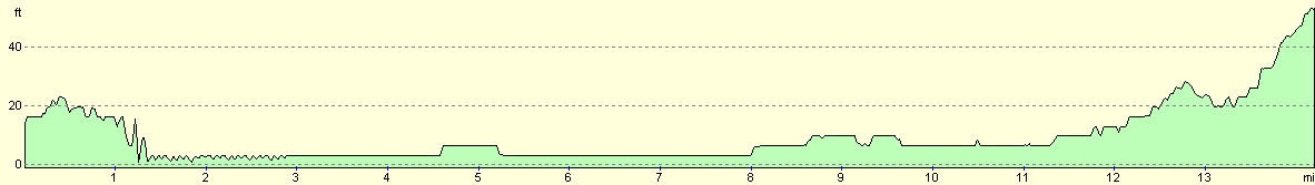
For more information on profiles, ascents and descents, see this page
Transport
There are regular bus services from Snettisham back to King's Lynn, running hourly even on a Sunday. These services start off from Hunstanton, and also call at Dershingham, Sandringham and Wooton.
Disclaimer
Please note that I take no responsibility for anything that may happen when following these directions. If you intend to follow this route, then please use the relevant maps and check the route out before you go out. As always when walking, use common sense and you should be fine.
If you find any information on any of these routes that is inaccurate, or you wish to add anything, then please email me.
All images on this site are © of the author. Any reproduction, retransmissions, or republication of all or part of any document found on this site is expressly prohibited, unless the author has explicitly granted its prior written consent to so reproduce, retransmit, or republish the material. All other rights reserved.
Although this site includes links providing convenient direct access to other Internet sites, I do not endorse, approve, certify or make warranties or representations as to the accuracy of the information on these sites.
And finally, enjoy your walking!
This walk was mentioned in the following routes:
| A walk around East Anglia |
Nearby walks
| # | Title | Walk length (miles) |
|---|---|---|
| 4 | Downham Market to Watlington | 6.2 |
| 9 | Old Hunstanton and Holme | 4.0 |
| 28 | Kings Lynn to Watlington | 7.4 |
|
|

|