Walk #157: Wolverton to Bugbrooke
 |
 |
|
General Data
| Date Walked | 30/09/2001 |
| County | Buckinghamshire, Northamptonshire |
| Start Location | Wolverton Station |
| End Location | Bugbrooke |
| Start time | 08.41 |
| End time | 15.06 |
| Distance | 16.6 miles |
| Description | This was a pleasant walk following The Grand Union Canal as it heads northwards through Northamptonshire. This walk is quite flat, with aonly a litte ascent through some locks. |
| Pack | 30-litre daysack containing coat, trainers, digital camera and a spare top. |
| Condition | I am a little fatigued after this walk. I used my old Saloman boots for the first time in a while, and I have blisters on all of my little toes. This caused me the most trouble towards the end of the walk, and I was glad when the walk ended. |
| Weather | On the journey from Cambridge the rain was very heavy, and this was still the state when I arrived at Wolverton Station. Fortunately within about ten minutes of starting the walk the rain started to decline and eventually stopped. Just before I stopped for lunch at Stoke Bruerne it started to rain again, and after I restarted the rain was heavier. Indeed a few minutes after I restarted it really started to pour, so I sheltered with a few other people in a building by the south portal of Blisworth Tunnel for a while. The rain continued for about twenty minutes before slowly declinging and being replaced with some fairly hot sunny periods. There was not much winfd about, which made the rain more bearable, and the temerature was about 18 degrees celsius. |
| OS map | Landranger number 152 (Northampton & Milton Keynes) |
 |
 |
|
Map of the walk
Maps courtesy of Google Maps. Route for indicative purposes only, and may have been plotted after the walk. Please let me have comments on what you think of this new format. For a detailed table of timings for this walk, please see the table file.
Notes
I set off doing this walk with the knowledge that, with the year nearly three-quarters of the way through, I had to get on if I was to finish the walk to Birmingham before the end of the year. Unfortunately transport starts to get fairly remote on the northern section of the walk until you get past Leamington Spa, so the walk has to be planned fairly carefully to allow me to get back to the starting point of each walk.
This walk was, as is usual with canal walking, pleasant at all times scenically, as canals tend to form their own green corridors. Even when the A508 started to encroach on the canal near Grafton Regis the noise was not too intrusive, and only the tallest lorries could be seen. There were no real hills on the route of this walk, and some long views were available to the east over the floodplain of the River Tove.
I must admit that I was a little disappointed by the Wolverton Aqueduct which carries the canal over the River Great Ouse, as I was expecting something a little more dramatic. Unfortunately from the top it appeared to be very short - barely the width of the river being covered, with the floodplain being covered by a large embankment. Indeed it would have been very easy to miss the aqueduct if you were not expecting it or missed the information board at the southern end. It is a scheduled Ancient Monument and before it was built the canal descended down to the floodplain of the River Ouse by four locks before rising up the other side in a similar manner. This system was replaced initially by a brick aqueduct, but this soon collapsed and was replaced by the existing structure.
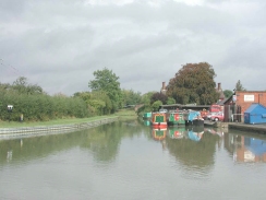
There is a little waterways museum at Stoke Bruerne. I did not go inside, but the sight of a milepost with my home town of Uttoxeter on it made me smile - Uttoxeter has not had a canal to it for many years, as the old canal from Stoke-on-Trent was covered over in part by the old Uttoxeter to Leek railway line. Recently much of the old railway has been destroyed by a road, making me wonder what would be the fourth form of transport to use that particular route.
I stopped for food at the Boat Inn in Stoke Bruerne, which is just to the west of the top lock. The food here was excellent, and I had a very nice breakfast (which is only served until midday). This was very large, and when washed down with a pint of Adnams and a cup of coffee was a real treat. I can thoroughly recommend this pub, particularly as the people within it were very friendly.
The weather came very near to spoiling this walk, as it was very wet for some periods, particularly after I stopped for lunch. Fortunately when it dis not rain hard for very long, and my trousers soon dried and my top did not get wet through my coat. Indeed the rain actually made me feel quite good as it enlivened me in a strange way, and I felt worse alter on in the walk when the sun came out and I warmed up considerably.
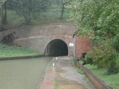
By the southern portal of Blisworth tunnel is a ring of concrete lying against the cutting side which is an example of the concrete lining used in 1984 when the tunnel was repaired. It showed well the diameter of the tunnel, which is larger than I was expecting until I remembered that this was a broad and not a narrow canal. Unfortunately due to the heavy rain I did not get the opportunity to take a photograph of this - I did not want to get my digital camera out in such a downpour. Next to the southern tunnel portal there is an old hut which, according to a sign on the door, is an old smithy which is being converted back into a blacksmiths shop and was due to open soon. A little further down the towpath there was another hut that was open, which I huddled in for a few minutes with a few other people whilst we waited for the heavy rainfall to slacken.
My next walk along the Grand Union Canal will probably take me from Bugbrooke northwards and then westwards as far as Braunston. Hopefully I can then catch a bus down to Daventry and then get the 40 back to Bugbrooke. This will leave me with only three walks to complete to get to Birmingham, which is a nice thought.
Directions
This walk starts at Wolverton Station, just on the northern outskirts of Milton Keynes. Turn right out of the station car park and follow a road as it heads up the hill and turns to the right to cross over the railway line. Immediately beyond the railway some steps to the right lead down to the canal towpath.
Follow the canal towpath as it heads westwards for about a mile past the old Wolverton railway works. The canal passes under a road bridge and then starts to head north-westwards, crossing the River Great Ouse by an aqueduct. The canal then passes through the centre of Cosgrove before heading in a roughly northwesterly direction until it passes about half a mile to the northeast of Yardley Gabion.
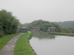
From here the canal continues to meander on a rough northerly heading until it reaches a bridge under the A508 road at the locks at Stoke Breurne. The towpath continues on the eastern side of the canal for about half of a mile until the southern end of Blisworth tunnel is reached.
The towpath leaves the canal and rises up via a track to meet a minor road. The path continues along this road for a couple of kilometres past Buttermilk Hall and Blisworth Hill Farms, and starts to descend down towards the village of Blisworth. As it descends a car park becomes visible to the left, and a footpath leads from this car park down to join the canal once more.
The canal skirts to the west of Blisworth before heading north to pass under the railway line and then the A42(T) dual carriageway. The canal then turns to head in a roughly northwesterly direction, until a road bridge (number 38) is reached.
On the southern side of the bridge some steps lead up to a road. Turn right down this road for about one hundred yards until a T-junction is reached with Great Lane. Turn right down Great Lane and follow it as it bends round to the north. The Baker's Arms pub and the bus stop are to the left when this road ends at a T-junction with the High Street.
Further information
|
The walk is also covered in detail in the Grand Union Canal Walk, by Anthony Burton and Neil Curtis, ISBN 1 85410 244 3, published by Aurum Press Ltd. Click on the image to the right to go the Amazon page for this book.
For more details on the Grand Union Canal see Jim Shead's canal pages. |
|
Distances
| From | To | Distance (m) | Ascent (ft) | Descent (ft) |
|---|---|---|---|---|
| Wolveton Station | Stoke Bruerne | 8.7 | 253 | 190 |
| Stoke Bruerne | North end of Blisworth Tunnel | 2.2 | 180 | 121 |
| North end of Blisworth Tunnel | Baker's Arms, Bugbrooke | 5.7 | 207 | 276 |
This makes a total distance of 16.6 miles, with 640 feet of ascent and 587 feet of descent.
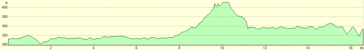
For more information on profiles, ascents and descents, see this page
Transport
Bugbrooke is on the 40 bus route from Daventry to Northampton, and the buses stop at the Baker's Arms in the village, about half a mile from the canal. There are also two stops nearer the canal if you are short of time. The buses run roughly hourly during the day on Monday to Saturdays, with no service on Sundays. The bus route as a stop at Northampton railway station, from where a train can be caught south to the start of the walk at Wolverton Station. Note that the 40 bus may also call at Weedon a few miles further up the canal which would be handy if you want to extend this walk slightly.
Disclaimer
Please note that I take no responsibility for anything that may happen when following these directions. If you intend to follow this route, then please use the relevant maps and check the route out before you go out. As always when walking, use common sense and you should be fine.
If you find any information on any of these routes that is inaccurate, or you wish to add anything, then please email me.
All images on this site are © of the author. Any reproduction, retransmissions, or republication of all or part of any document found on this site is expressly prohibited, unless the author has explicitly granted its prior written consent to so reproduce, retransmit, or republish the material. All other rights reserved.
Although this site includes links providing convenient direct access to other Internet sites, I do not endorse, approve, certify or make warranties or representations as to the accuracy of the information on these sites.
And finally, enjoy your walking!
This walk was mentioned in the following routes:
| Grand Union Canal Walk |
Nearby walks
| # | Title | Walk length (miles) |
|---|---|---|
| 137 | Market Harborough to Northampton | 18.3 |
| 143 | Cheddington Station to Bletchley Station | 13.3 |
| 146 | Bletchley to Wolverton | 11.9 |
|
|

|