Walk #158: Bugbrooke to Braunston
 |
 |
|
General Data
| Date Walked | 06/10/2001 |
| County | Northamptonshire |
| Start Location | Bugbrooke |
| End Location | Braunston |
| Start time | 09.05 |
| End time | 14.43 |
| Distance | 15.1 miles |
| Description | A nice walk heading northwards and then westwards along the Grand Union Canal. Unfortunately it was slightly spoilt by the close proximity of the M1 motorway for part of the time. |
| Pack | 30-litre daysack containing coat, trainers, digital camera and a spare top. |
| Condition | Fine. I have very few problems whatsoever, and could easily have walked for another three or four miles with little effort, particularly if I had had a rest. I had a slight sore spot on the ball of my left foot about midway through the walk, but this soon disapperared. My backand legs are fine. |
| Weather | The forecast today was for the weather to be very bad, so it wasarted clouds with some trepidation that I set out. When I parked my car at Braunston the sun was shining through parted clouds, so I felt slightly better when the walk started. What followed was a day which had a mixture of sunshine and cloud, with a few black clouds threatening rain. Fortunately this rain held off, and despite a few drops blown in the wind just before I stopped fr lunch the day remaind dry. Towards the end of the walk it was a lovely day, with a reasonably high temperature for the time of yer being marked doen in exposed places by a fairly strong wind. |
| OS map | Landranger number 152 (Northampton & Milton Keynes) |
 |
 |
|
Map of the walk
Maps courtesy of Google Maps. Route for indicative purposes only, and may have been plotted after the walk. Please let me have comments on what you think of this new format. For a detailed table of timings for this walk, please see the table file.
 |
Notes
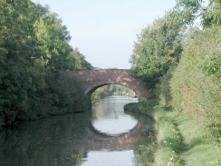
This was an enjoyable little walk following the canal as it headed northwards through Northamptonshire.
The worst point of this walk was the close proximity of the M1 motorway for a couple of miles to the south of Long Buckby. To make matters slightly worse the railway line was also very near to the west, but the occasional bursts of noise from the trains were drowned out by the ever-present roar of the motorway.
I lost my pen somewhere near Watling Street Bridge, and so had to use my mobile phone to text message myself the times that I reached certain locations. Fortunately at Whilton Bottom Lock there was a chandlery, where I bought some chocolate, and they kindly gave me a pen when I explained my problem. This was a piece of generosity for which I am truly grateful.
The end of this walk was just a very short distance from the Northamptonshire / Warwickshire border, which was annoying as I would not mind to get another county ticked off on my counties list. Unfortunately this will now have to wait for my next canal walk.
The towpath at the western end of Braunston Tunnel was very boggy, and after attempting to avoid the wet patches for a few minutes I decided to just plough on trough the deep puddles. Fortunately this did not last too long, as Braunston Top Lock came into sight quickly and the boggy sections of path were thankfully replaced with firm towpath.
I now have only just over forty miles to walk to reach Gas Street Basin in Birmingham and the end of the walk. I am now fairly sure that I shall be able to do this in three days walking, with the next one being to Royal Leamington Spa.
This walk went past the junction with a couple of other canals; at Norton Junction it met up with the Grand Union Canal Leicester Branch; and at the end of the walk I reached Braunston Junction, where the Oxford Canal (Northern Section) meets the Grand Union Canal. The former will allow me to get to Leicester and meet up with the walks that I did earlier in the year; whilst the later would allow me to get to get to the Coventry Canal and Coventry. Both of these are nice walks to be done sometime in the future, perhaps next year.
On the western end of Braunston Tunnel there was a plaque that read: "This plaque records the bicentenary of the opening of the Braunston Tunnel ans the nine miles of Grand Junction Canal between Braunston and Weedon on 21st June, 1976. It was opened at 2 O'Clock when the local committee of ladies and gentlemen, preceded by their chairman, Wm Praed Esq, M.P. Two flags and an excellent band of music, embarked on two boats attended by an immense concourse of people.. This plaque was unveiled at 2 O'Clock on 15th June 1996 by Tim Boswell Esq, M.P. for the Daventry constituency."
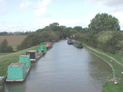
Braunston was a very attractive little village, and the canals were a hive of activity when I passed with some sort of narrowboat gala going on. More boats were turning up as I walked past and I was wondering where they would be able to moor; already boats were moored two or three abreast.
I had a thirty minute wait at Daventry bus station, a place where I have only been once before for a party and had no real wish to go again. A surprise was to be found beside the station, however, in the form of an old industrial railway locomotive. This was a surprising find and I have yet to discover exactly what it was doing there.
Directions
This walk starts off by the King's Arms Pub in Bugbrooke. Turn right out of the pub and head down the High Street for about fifty yards. Turn down Great Lane and follow this road as it pases over a stream before it turns sharply to the right. A short distance after the bend a road is met coming in from the left. Turn left down this road for a hundred yards until the canal is reached. Turn left to go down the steps to the canal towpath, and then turn right to head north up the canal.
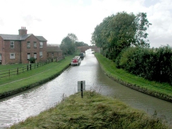
The canal towpath winds its way in a roughly north-westerly direction, passing to the west of Nether Heyford and crossing under the A5(T) Fosse Way to the east of Weedon Beck. It then turns to a northerly direction, passing under the A5(T) once more before becoming hemmed in between the M1 to the ease and the A5(T) and the West Coast Railway line to the west. This continues until the locks at Long Buckby.
After the locks the canal swings around to head westwards, passing under the railway and the A5(T). Shortly after this Norton Junction is reached, where the Grand Union Leicester branch leaves to head northwards to Leicester. Use a footbridge to cross over the Leicester branch, and then follow a footpath along the north side of the Grand Union Canal for a short distance to another bridge.
At this bridge the towpath crosses over to the southern side of the canal and follow it for just under two miles to the eastern end of Braunston Tunnel. Here the towpath rises up to go over the hill by means of a farm track. Cross over the A361 main road and the track starts to descend beside some air shafts for the tunnel down to the western portal, where a plaque commemorates the opening of this stretch of canal.
From the western tunnel portal the towpath follows the southern side of the canal to Braunston top lock. Once the bottom lock has been passed a bridge carries the towpath over the entrance to a marina, and then it continues on to pass under the A45(T) road. Shortly after this splendid twin cast-iron bridges carry the towpath over a triangular junction between the Grand Union Canal and the northern section of the Oxford canal.
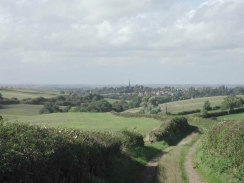
Cross the bridge and follow the Oxford canal northwards, passing under the A45(T) again to the next bridge, which carries a track and footpath over the canal. There is no direct connection between the canal towpath and the footpath, but a fence on the southern side of the bridge provided an easy access point. Cross the bridge and use the footpath to head up the hill, heading towards the church. When the footpath meets the High Street turn left onto it and pass the church. Continue along the road heading eastwards through the village of Braunston to the bus stop near the eastern side of the village at the junction of Ashby and Welton Road.
Further information
|
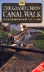
The walk is also covered in detail in the Grand Union Canal Walk, by Anthony Burton and Neil Curtis, ISBN 1 85410 244 3, published by Aurum Press Ltd. Click on the image to the right to go the Amazon page for this book.
For more details on the Grand Union Canal see Jim Shead's canal pages. |
|
Distances
| From | To | Distance (m) | Ascent (ft) | Descent (ft) |
|---|---|---|---|---|
| Bugbrooke | Long Buckby | 8.7 | 413 | 358 |
| Long Buckby | Braunston Junction | 5.5 | 276 | 292 |
| Braunston Junction | Braunston | 0.9 | 92 | 13 |
This makes a total distance of 15.1 miles, with 781 feet of ascent and 663 feet of descent.
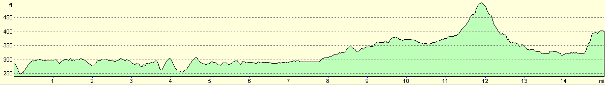
For more information on profiles, ascents and descents, see this page
Transport
Braunston is served by buses running from Rugby in the north to Daventry in the south. If you catch one of the Geoff Amos Coaches GA1 buses down to Daventry then it is possible to change to the hourly No. 40 bus service to Northampton, which calls at Bugbrooke.
Disclaimer
Please note that I take no responsibility for anything that may happen when following these directions. If you intend to follow this route, then please use the relevant maps and check the route out before you go out. As always when walking, use common sense and you should be fine.
If you find any information on any of these routes that is inaccurate, or you wish to add anything, then please email me.
All images on this site are © of the author. Any reproduction, retransmissions, or republication of all or part of any document found on this site is expressly prohibited, unless the author has explicitly granted its prior written consent to so reproduce, retransmit, or republish the material. All other rights reserved.
Although this site includes links providing convenient direct access to other Internet sites, I do not endorse, approve, certify or make warranties or representations as to the accuracy of the information on these sites.
And finally, enjoy your walking!
This walk was mentioned in the following routes:
| Grand Union Canal Walk |
Nearby walks
| # | Title | Walk length (miles) |
|---|---|---|
| 137 | Market Harborough to Northampton | 18.3 |
| 157 | Wolverton to Bugbrooke | 16.6 |
| 162 | Braunston to Leamington Spa | 16.6 |
|
|

|