Walk #159: Snettisham to Hunstanton
 |
 |
|
General Data
| Date Walked | 07/10/2001 |
| County | Norfolk |
| Start Location | Snettisham |
| End Location | Hunstanton bus station |
| Start time | 09.37 |
| End time | 13.07 |
| Distance | 10.3 miles |
| Description | This was a lovely walk following the coast northwards into Hunstanton. |
| Pack | Today I carried my 30-litre daysack containing coat, trainers, digital camera and a spare top. |
| Condition | I feel fine after this walk. I had absolutely no trouble from any part of my body, which was a great relief. This was despite the fact that I did a long walk yesterday which had tired me out. I have no new blisters on my feet, and my feet did not ache despite the fact I used my Saloman X-Adventure 7's. |
| Weather | The forecast today was for some awful weather, but as this was a fairly short walk I decided to press on regardless. For the second day in a row the weather forecast proved less than accurate and the only rain I saw all day were a few spots on the first part of the walk from Snettisham to the beach. The rest of the day was a mixture of sunshine and cloud, with a fairly stiff wind keeping temperatures down. When the sun was shining, however, it made for very nice walking weather. The forecast was not too inaccurate, however, as my girlfriend reported that at times it was pouring with rain in Cambridge, and it rained as I drove home as well. |
| OS map | Landranger number 132 (North West Norfolk, King's Lynn & Fakenham) |
 |
Map of the walk
Maps courtesy of Google Maps. Route for indicative purposes only, and may have been plotted after the walk. Please let me have comments on what you think of this new format. For a detailed table of timings for this walk, please see the table file.
Notes
The initial part of this walk from Snettisham to the beach past Shepherd's Point was fairly boring, not the least because I had walked it a few weeks before in the opposite direction. It was also further than I normally like to have to walk to get to the start of a walk, as it took me three-quarters of an hour to reach the beach at Snettisham Scalp and the start of the walk proper. Despite this it was a quite nice section, only spoilt by the occasional car rushing past me on the way to the beach.
I have always thought of Hunstanton as being a very touristy, boring place, but as I walked to the bus station from the clifftop car park in Old Hunstanton I found it to be a better place than I had expected. I had only every driven through it in a car, and to be frank I had not been that impressed with it. Perhaps it was the fact that the sun was shining which made a difference (I had previously visited it in winter), but it seemed to be a relatively nice seaside town, and was not as tacky as many seaside towns seem to be.
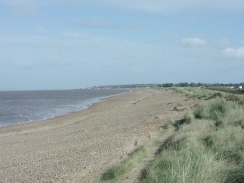
The going from Heacham was very easy, because as far as the cliffs in Hunstanton it follows the top of a concrete sea wall. Of corse there is an alternative route available along the beach at the bottom of the sea wall, but I opted for the easier solution of walking along the concrete sea wall. There were some very nice chalets along this stretch along with some not so pretty ones, and there were even a few that were nearly palatial in style. These chalets are very pricey for buildings that must only get used for a small proportion of the year, and I wonder how much use they really must get.
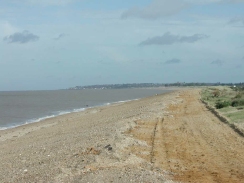
The area between Snettisham and Heacham was harder going, as the mixture of sand and shingle that made up the beach showed signs of some very recent repairs (and indeed signs warning of heavy plant were still visible). These repairs were repairing damage caused a few weeks earlier, when the sea defences had nearly been washed through. The repairs were urgent patching up ready for the winter, and in late October a 31-million pound scheme was announced to renew the defences all the way up to Hunstanton over the next few years.
There were plenty of windsurfers in the sea today around the Hunstanton and Heacham area, taking advantage of the windy weather. There were also plenty of jet-skiers and powerboaters. One jet-skier in particular was showing off very close to the beach, throwing spray from his engine over people in the surf. It looked as though it may be relatively nice weather to be doing this, although I must admit I would not like to be in the water at this time of year.
When I parked my car outside the Old Bank Bistro in Snettisham I walked to the bus stop to check the timetable. A few weeks before the buses had run hourly on Sundays, but a new autumn timetable had come into force today that meant the first bus set off at 10.20, with a three-hour gap to the next one at 13.20. Fortunately I managed to get this bus, as the next one was not until 15.30 and I did not fancy twiddling my thumbs in Hunstanton for too long. This is a problem that I find with my walking; if I have to make a journey at the end of the walk then I do not like having to hang around waiting to make that journey.
Directions
This walk starts in the little village of Snettisham, which is just off the A149 road. I started walking from a bus stop on the B1440 road near the junction with Old Church Road. Turn left and walk south along the B1140 Lynn Road until you meet a junction with Station road to the right. Turn right down Station Road and follow it west for about one kilometre until it becomes Beach Road and meets the A149 road.
Cross the A149 road and follow Beach Road west for three kilometres to Shepherd's Point and the sea and car park at Snettisham Scalp. Turn right and follow the beach northwards, squeezing between the sea to the west and Heacham Harbour to the east for a few miles until you reach the outskirts of the village of Heacham.
At the first car park you reach in Heacham there are some shops so that you can buy an ice cream, and some public toilets are also there. The walk continues northwards along the beach, following the seafront to another car park on the northern edge of Heacham.
From here the walk follows the beach northwards, following the top of the concrete sea wall. As it progresses it passes many sea chalets, all of which must have some lovely views over the Wash. The seawall continues for a couple of miles until the southern outskirts of the town of Hunstanton is reached.
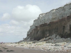
The seawall becomes busier as it heads northwards into Hunstanton, passing a sea life centre and a fairground en route. Shortly after the fairground the seawall ends at some cliffs. Descend to the beach and follow the cliff northwards as it slowly starts to descend. When the top of the cliff finally reaches beach level a sandy path leads up to the remains of a chapel at Old Hunstanton.
From the chapel join the B1161 Cliff Parade road and head southwards for a little over a kilometre until the centre of the town is reached. The bus station is situated in the centre of the town near St Edmund's Terrace. This last section of the walk involved doubling back on myself as Old Hunstanton is about a kilometre north of the bus station in Hunstanton; however a previous walk had ended at Old Hunstanton so I needed to get there to say that I had completed this section of the coastal walk.
Distances
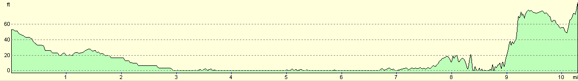
| From | To | Distance (m) | Ascent (ft) | Descent (ft) |
|---|---|---|---|---|
| Snettisham | Sherpherd's Port | 2.2 | 59 | 16 |
| Shepherd's Port | Hunstanton sea life center | 5.3 | 23 | 30 |
| Hunstanton sea life center | Hunstanton bus station | 2.8 | 187 | 102 |
This makes a total distance of 10.3 miles, with 269 feet of ascent and 148 feet of descent.
For more information on profiles, ascents and descents, see this page
Transport
There are regular bus services from the bus station in Hunstanton which call at Snettisham on route to King's Lynn. These run on Sundays, but at a reduced service, particularly in winter.
Disclaimer
Please note that I take no responsibility for anything that may happen when following these directions. If you intend to follow this route, then please use the relevant maps and check the route out before you go out. As always when walking, use common sense and you should be fine.
If you find any information on any of these routes that is inaccurate, or you wish to add anything, then please email me.
All images on this site are © of the author. Any reproduction, retransmissions, or republication of all or part of any document found on this site is expressly prohibited, unless the author has explicitly granted its prior written consent to so reproduce, retransmit, or republish the material. All other rights reserved.
Although this site includes links providing convenient direct access to other Internet sites, I do not endorse, approve, certify or make warranties or representations as to the accuracy of the information on these sites.
And finally, enjoy your walking!
This walk was mentioned in the following routes:
| A walk around East Anglia |
Nearby walks
| # | Title | Walk length (miles) |
|---|---|---|
| 9 | Old Hunstanton and Holme | 4.0 |
| 133 | Hunstanton to Burnham Deepdale | 10.3 |
| 156 | Kings Lynn to Snettisham | 14.6 |
|
|

|