Walk #160: Wells-Next-The-Sea to Cley-next-the-Sea
 |
 |
|
General Data
| Date Walked | 13/10/2001 |
| County | Norfolk |
| Start Location | Wells-next-the-Sea |
| End Location | Cley-next-the-Sea bus stop |
| Start time | 10.20 |
| End time | 14.01 |
| Distance | 11.1 miles |
| Description | This was a pleasant walk following the North Norfolk Coast Path as it heads eastwards towards Cromer. Although this was a coastal walk, I never actually got to see the sea at any stage due to the mudflats in the way. |
| Pack | Today I carried my 30-litre daysack containing coat, trainers, digital camera and a spare top. |
| Condition | I feel fine after this relatively short walk. I walked the last few miles at a fairly fast rate so that I could get to the bus stop in time, but despite this I felt fine at the end. I could easily have walked further if I had needed to. My legs are fine and I have no new blisters, and my back is fine as well. |
| Weather | The weather today was quite hot for the time of year. There was some low hazy cloud which meant that I never caught the full power of the sun, bt despite this I got quite sweaty. There was no sign of any rain from the thin cloud, and there was hardly any wind to help to keep me cool. |
| OS map | Landranger number 132 (North West Norfolk, King's Lynn & Fakenham) and Landranger number 133 (North East Norfolk, Cromer & Wroxham) |
 |
Map of the walk
Maps courtesy of Google Maps. Route for indicative purposes only, and may have been plotted after the walk. Please let me have comments on what you think of this new format. For a detailed table of timings for this walk, please see the table file.
Notes
This was a lovely walk on a beautiful warm autumnal day. Despite this being a coastal walk I did not get to see the sea for any of the walk, as it was always out if sight behind the mudflats. Despite this it was possible to see from driftwood where the high tides reached, and in places this was actually beyond the path, showing that during certain tidal conditions this walk could become more challenging.
I stopped for a rest at the car park in Morston, where a portable caf� had just opened for the day. It specialised in seafood, so I had a wonderful fresh crab sandwich washed down with a small bottle of orange juice. The lady serving in the caf� was from Perth in Australia, so I chatted to her for a while about her country.
Unfortunately this walk got off to a slightly inauspicious start, as 15 minutes after I had left home I realised I had left my camera at home. Because I still wanted to take advantage of the good weather and do a walk, when I got to Wells-next-the Sea I bought a disposable camera from one of the seafront shops. Buying a disposable camera could be seen as a waste of money, but at least it meant that I did not have to make the trip again to get some photographs which would have cost the same amount in fuel.
The next challenge was reached about a kilometre after setting off. A little creek is reached, and the 1:50,000 OS map clearly shows a footpath heading over the creek. Because this appeared to be the North Norfolk Coast Path (the other footpath continued along the flood banking and did not meet up on the other side of the creek) I decided to progress down to the floodplain. The going was a little muddy towards the creek but the path was well trodden, but as I got nearer to the creek I could see that a bridge carrying the path over it was in a very dishevelled state of repair. Indeed, as I got up to it I discovered that it comprised solely of uprights with no wood to walk on. This meant that I had to return the short distance to the floodbank and follow it around, a path which is not marked on the map allowing this to be done. When I got back to the floodbank I found that there was no sign showing that the correct route was along the top of the bank, which is a silly state for a national trail to get into.
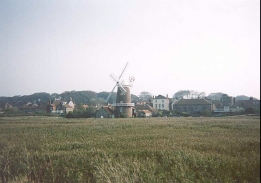
Cley-next-the-Sea is a lovely picturesque little village, with some lovely buildings set off by a marvellous example of a windmill. It was a very distinctive place to finish this walk, and it will be a nice place to start off the next stage of this walk. It seems to be a very unspoilt little seaside village, with none of the shops being intrusive into the general character of the village. The narrow winding streets which carry the main road through the village also add to a cosy atmosphere which left me enchanted.
Yet again I was lucky with the bus times, getting to the bus stop seven minutes before the bus back to Wells-next-the-Sea was due, continuing my run of good luck where transport from the end of my walks is concerned. When I got back to Wells-next-the-Sea I made my girlfriend very happy by buying her some fresh seafood at a stall which was parked near my car in the car park.
I now have one short day's walk left to do to get as far as Sheringham, which means that I am getting nearer and nearer finishing off my walk around East Anglia. The section to Sheringham apparently involves walking a long way along a shingle beach, which in my opinion is always a harder job than walking along sand and therefore I shall try to take my time over this. I shall then be within very easy access of the highest point of Norfolk at Beacon Hill, between Sheringham and Cromer.
Directions
This walk starts off in the harbour car park at Wells-next-the-Sea. As this walk follows the North Norfolk Coast Path it is fairly well signposted, with a couple of exceptions noted below.
Exit the car park and turn left to follow the B1105 eastwards for a short distance. When the road turns sharply to the right to head southwards away from the sea, continue straight on along a minor road towards the outskirts of the town.
When this road starts to veer to the right, continue on along a well-signposted footpath. This joins some flood banking which continues to the east. When the flood banking starts to veer to the right, follow it and do not attempt to follow the footpath that is marked on the 1:50,000 OS maps as the bridge over the creek is not present. Instead keep to the banking and follow it as after a short distance it turns to the left to head eastwards once more. A gate soon blocks the path at the top of the flood banking, but a footpath descends to the left off the flood banking to join with the footpath off the dilapidated bridge.
From there the path continues to skirt the southern edge of some wide mudflats, which were empty when I visited but are covered at high tides. It crosses the Warham Greens and proceeds for about three and a half kilometres to the outskirts of Stiffkey.
The path meets end-on with a rough track at a car park in Stiffkey. Continue along this track as it heads eastwards, skirting a creek to the north before meeting end-on with a road coming from the south from the eastern end of Stiffkey village. From here the route follows a footpath that heads for a little over a mile across Stiffkey greens, before it ascends to the top of a little floodbank.
At the eastern end of the floodbank the track descends and turns sharply to the left to head northwards for a little distance. It then turns to the right and follows a track eastwards to the little settlement of Morston. Head for the car park in Morston, where there are some seats available if you want to have a rest.
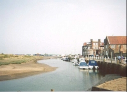
The path leaves Mortson by following the top of the flood banking eastwards from the car park. At the eastern end of the flood banking the path descends and can be easily followed across to meet the Agar Creek on the outskirts of the village of Blakeney. The path emerges into Blakeney by a little quay on The Quay road. There were some boats tied up on the quay offering trips to watch seals nearby. Once past the quays heads for the car park, from where a path leaves to the left to heads northwards along the flood banking. Do not follow the path that heads north slightly to the west on a lower level, as this is a dead end.
The path on top of the flood banking continues out of Blakeney for about a kilometre before turning to head eastwards to Blakeney Eye. At Blakeney Eye it turns south towards the windmill in Cley-next-the-Sea. All of this section in very easy to navigate along as the path follows the top of the floodbank. The path meets the A149 road and a path takes you down to the bridge over the River Glaven, and soon the village of Cley-next-the-Sea is entered.
There is a bus stop just on the right as you enter the village which will take you back to Wells-next-the-Sea; I chose to walk along the A149 through the village to a bus stop further out. As the A149 road turns left in Cley, follow it along the narrow roads past the windmill as it makes a series of small turns to the right. The next bus stop is on the right-hand side of the A149 just before the junction with a minor road (Beach Road) which heads north up to the sea at Cley Eye.
Distances
| From | To | Distance (m) | Ascent (ft) | Descent (ft) |
|---|---|---|---|---|
| Wells-next-the-Sea | Stiffkey | 3.7 | 92 | 82 |
| Stiffkey | Blakeney | 4.3 | 98 | 108 |
| Blakeney | Cley-next-the-Sea | 3.1 | 66 | 46 |
This makes a total distance of 11.1 miles, with 256 feet of ascent and 246 feet of descent.
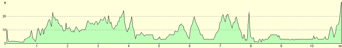
For more information on profiles, ascents and descents, see this page
Transport
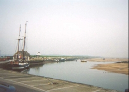
I used the Coasthopper service that runs between Sheringham and King's Lynn to get back from Cley-next-the-Sea to Wells-next-the-Sea. This bus stops at the harbour, where there is a small car park which fills quite early in the morning.
Disclaimer
Please note that I take no responsibility for anything that may happen when following these directions. If you intend to follow this route, then please use the relevant maps and check the route out before you go out. As always when walking, use common sense and you should be fine.
If you find any information on any of these routes that is inaccurate, or you wish to add anything, then please email me.
All images on this site are © of the author. Any reproduction, retransmissions, or republication of all or part of any document found on this site is expressly prohibited, unless the author has explicitly granted its prior written consent to so reproduce, retransmit, or republish the material. All other rights reserved.
Although this site includes links providing convenient direct access to other Internet sites, I do not endorse, approve, certify or make warranties or representations as to the accuracy of the information on these sites.
And finally, enjoy your walking!
This walk was mentioned in the following routes:
| A walk around East Anglia |
| Peddars Way and Norfolk Coast Path |
Nearby walks
| # | Title | Walk length (miles) |
|---|---|---|
| 134 | Burnham Deepdale to Wells-Next-The-Sea | 9.5 |
| 165 | Cley-next-the-Sea to Cromer | 13.1 |
| 254 | Hunstanton to Wells-next-the-Sea | 21.7 |
|
|

|