Walk #254: Hunstanton to Wells-next-the-Sea
 |
 |
|
General Data
| Date Walked | 02/11/2002 |
| County | Norfolk |
| Start Location | Hunstanton sealife centre |
| End Location | Wells-next-the-Sea |
| Start time | 08.20 |
| End time | 16.13 |
| Distance | 21.7 miles |
| Description | This was a nice walk, following the Norfolk Coast path eastwards from Hunstanton towards Wells-next-the-Sea. |
| Pack | Today I carried my 30-litre Karrimor HotRock rucksack, which was filled with my packed lunch, waterproof leggings, water bottle and a couple of spare shirts, together with the usual assortment of odds and ends. |
| Condition | For the majority of this walk I felt absolutely fine, with no problems to report. However once I got to Holkham Gap I started to feel fatigued, and my left foot started hurting in a few places. This was made worse by the fact that I was trying to hurry because of the light rain that had started falling, which with hindsight was a mistake. Aside from this I am fine, and yet again I do not have any blisters. |
| Weather | The weather today started off sunny, with only hazy patchy cloud overhead. The cloud slowly gathered during the day, and by the time I got Holkham Gap it started to drizzle, which was followed by a light rain once I had reached the van. This then became a heavy rain that continued for most of the night. |
| OS map | Landranger number 132 (North West Norfolk, King's Lynn & Fakenham) |
 |
 |
|
 |
 |
|
Map of the walk
Maps courtesy of Google Maps. Route for indicative purposes only, and may have been plotted after the walk. Please let me have comments on what you think of this new format. For a detailed table of timings for this walk, please see the table file.
 |
 |
|
 |
Notes
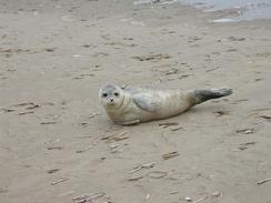
A quite sad event occurred today, which quite depressed me. Whilst walking eastwards along the beach towards Hokham Gap, I came across a young seal on the sand near the waterline. It looked up at me with a sad expression on its face (yes, I am anthropomorphising). I went closer to take some photos of it, and this is when I realised something was up; if you approach seals they usually move fast into the water, but this one just raised its tail. Some ore people approached, and a lady attempted to phone a seal sanctuary because it was obvious that this sea was in some distress. Despite trying two numbers we could not get through to anyone, and even if we had they probably would not have been able to do anything as they have stopped taking in seals with distemper to stop it spreading to ones that they already have in care. I left it with a tear in my eye. The tide was coming in, and as the waves lapped at it it was trying unsuccessfully to move itself further up the beach. It is a sad sight which I do not think that I will ever forget - a very poignant moment.
After she had dropped me off at Hunstanton Sam drove to Wells and parked at the campsite. She got her bike off the rack at the back of the van and rode down the A149 to meet me. We met at the church in Brancaster, and I suggested that we meet in half an hour at the pub marked at the map in Brancaster Staithes. She agreed and turned around to cycle back along the road, and I set off along the Norfolk Coast Path. The pub we stopped at is called the Jolly Sailors, and was a very nice pub where I had a couple of pints of very pleasant beer that went down my throat easily. With hindsight this was probably a mistake, as I found that the next hour of the walk was slightly harder for it. It was lovely to meet Sam for lunch, and it made me realise how much she is helping me complete this trip just by being there for me.
It seems that the most commonly made remark about Hunstanton is that it is the only resort on the east coast that faces west. That may be true, but for me the best thing about the town are the cliffs. These consist of a thick layer of white chalk that is topped off by a thin layer of red carstone, which gives the cliffs a lovely but strange appearance, which I have seen variously described as looking like a cake or a sandwich. As the cliffs head north they slowly dip under the ground, until at the end they are very small and insignificant before the sand overwhelms them and the dunes begin.
Between Hunstanton and Thornham I passed the beach at Holme, which became famous in 1999 following the discovery of 'Seahenge', a prehistoric timber circle discovered on the beach. I was lucky enough to see this in early 1999 when I was walking along the beach before it was removed for study.
On the way from the beach into Thornham I passed through the Norfolk Wildlife Trust's Holme Dunes Nature Reserve, which covers over 281 hectares between Lavender Marsh and Ragged Marsh (essentially taking in the seafront between Holme and Thornham).
Thornham Church seemed a strange church to me, as it appeared much taller than churches of an equivalent size, and had a 'tower' that was not much taller than the main body of the church. Apparently work on the tower was started but the Black Death intervened and work was not finished until the 1930's.
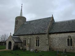
The church at the little hamlet of Burnham Deepdale is very attractive, and has three main features: A Saxon round tower, a Norman font and a collection of medieval glass. The tower in itself was quite spectacular and has been dated at being about 950 years old because it had a triangular headed doorway, it was constructed with some large puddingstone material near the base and the thickness of the walls was less than that of a Norman tower. On the wall on the entrance to the tower was a list of all the vicar's at the church since 1305, which was quite an amazing thought! The church has had major restorations three times, in 1797, 1855 and 1898. In the 1797 restoration the Norman font was broken and was taken to Fincham Rectory for repair, but stayed in a garden there for forty years before being returned!
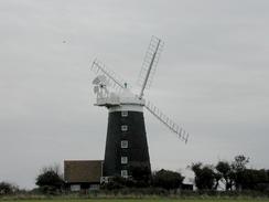
The windmill between Burnham Norton and Burnham Overy Staithe was a very nice example of this sort of building, with a nice location being matched by some pretty associated buildings. A recent map showed the windmill as being disused and the sails were not turning despite the blustery wind so it could be that the sails can no longer turn, but even so it is lovely to see such a nice example of this sort of building with its sails intact. It is apparently now let out as accommodation for holidaymakers, and it must make an unusual place to stay for a weekend!
Apparently Burnham Over Staithe is the place where it is thought hat Lord Nelson learnt to sail - he was born a couple of miles to the south at Burnham Thorpe. Nelson is being mentioned on television a great deal at the moment because he is in the list of the top ten greatest Britons who ever lived. It is nice to see someone who came to be so influential started life in such a tranquil area.
Wells-next-the-Sea was one of the greatest ports in Eastern England in Tudor Times, but since then access to the sea has reduced. It remains the only port on the North Norfolk Coast to be commercially viable (for instance Thornham saw it's last commercial ship in the 1930's). It is very much a tourist town, with a permanent population of 3,000 being joined by over 10,000 holidaymakers during the summer holidays. It is amazing to think about this increase in numbers as it did not seem that big a town - when it is busy it must be bursting at the seams! This makes me fairly glad that I visited it in January which is totally out of season. Look here for more information on Wells-next-the-Sea.
Directions
This walk starts off on the seafront outside the sea life centre in Hunstanton. From the centre head north, until the seafront walkway ends at the start of the cliffs. If the tide is out then the beach can be walked around the cliffs; if not then you will have to climb up the steps and walk around the top of the cliffs. Follow the cliffs around - the view of them from their base is lovely - until they end and are replaced with sandy dunes. These dunes are the place where the North Norfolk Coast path starts. You can choose to walk along the path behind the dunes or along the beach; I chose the latter.
Continue north-eastwards along the beach. Soon you pass the RNLI lifeboat station at Old Hunstanton, after which the coast starts to run to a more easterly heading. After a few miles you pass Gore Point, and about a mile east of the Point at about 720 450 turn south and head inland along the raised flood bank to the east of Broad Water.
Head south along the flood bank to the gate at the entrance to the nature reserve. Turn left and follow another flood bank east to the river and then south to eventually meet a road just to the north of Thornham. Cross the road and take a footpath to the left that leads eastwards before descending into Thornham.
When the road is met take Church Lane south out of Thornham until the A149 is met beside the church, with a nice little shop and cafe on the other side of the road. Turn left and follow the A149 for a couple of miles, passing through the hamlet of Titchwell until the church at Brancaster is reached, opposite the A149 / B1153 road junction.
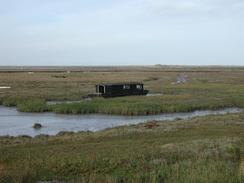
Turn left down a road that leads to a car park at Brancaster beach, and then turn right down a footpath that leads behind houses and immediately to the north of the Brandovnum roman fort. This path is part of the North Norfolk Coast Path, and is very boggy as it is on the fringe of the tidal area of Brancaster Mow Creek, and it is therefore handily raised up on a wooden causey which in places was slippy due to the rain that had fallen the previous night. Continue along this path eastwards as it parallels the A149 through Brancaster Staithe. When another section of flood bank is reached leading off to the left turn right and walk a short distance to the A149 at Burnham Deepdale church.
Leave the church and walk back to the junction n the flood bank. Follow the flood bank that heads off to the north as it winds around to the north of the village of Burnham Norton. After a few miles this bank turns sharply to the left around the southern edge of a litle creek and crosses the River Burn via a Sluice. On the other side of the sluice continue straight across a field towards the windmill. At the top eastern edge of the field near the windmill turn left and follow a path (which avoids you walking on a road) that skirts the edge of the field before joining the A149.
Descend downhill on a pavement beside the A149 into Burnham Overy Staithe. The road starts to bend around to the right and head eastwards, and shortly after it does so take a road to the left opposite a pub that leads to the harbour. Take the North Norfolk Coast Path as it heads along a flood bank on the eastern side of the River Burn estuary, and follow it as it heads out northwards to meet a large expanse of sand dunes. The path at the top of the flood bank was very muddy, so after a while I chose to walk along the bottom of the flood bank instead. The path eventually becomes a boardwalk and turns to the left and climbs up into the sand dunes. It then turns right to head northwards once more before ending at the beach.
Head eastwards along the beach, passing the edge of a wooded area past the dunes to the right before eventually reaching Holkham Gap, which is an obvious gap in the trees. Head south towards the car park at Holkham Gap, at the northern edge of which is a footpath leading off to the left on the southern edge of yet another wooded area.
The path skirts the southern edge of the woodland in a roughly easterly direction for about two and a half kilometres, until the lifeboat station at Wells-Next-The-Sea is reached. The campsite we stayed at for the night was just to the right from the road that heads down towards the main town.
Distances
| From | To | Distance (m) | Ascent (ft) | Descent (ft) |
|---|---|---|---|---|
| Hunstanton sealife centre | Brancaster | 9.4 | 295 | 266 |
| Brancaster | Burnham Overy Staithe | 6.3 | 135 | 164 |
| Burnham Overy Staithe | Wells-next-the-Sea campsite | 6.0 | 118 | 118 |
This makes a total distance of 21.7 miles, with 548 feet of ascent and 548 feet of descent.
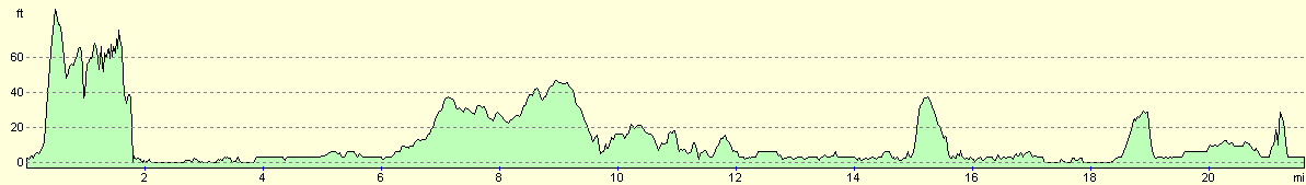
For more information on profiles, ascents and descents, see this page
Accommodation
We stayed at the Pinewoods Holiday Park, Pinewoods Partnership, Beach Road, Wells-next-the-Sea, Norfolk NR23 1DR. They can be contacted at 01328 710439. I must admit that this site did not really impress me - we filled the van up with water from a superpitch and found that it tasted slightly metallic, which could be something about the water supply that they have to may have been something to do with the tap. Whichever it was, we did not really feel like drinking lots of it and we will have to empty and refill the tank tomorrow. The toilets were clean but unexceptional, and the shower was complex - the first one that I went into did not work properly, and the second either gave out a slow trickle of hot water or a torrent of cold water - it appeared to work by adding cold water to a set amount of hot water, which meant that if you wanted a fast stream of water then it was cold. All in all I was not very impressed, but I did not get a chance to see any of the site's other facilities. Sam had an even worse time - the lights in the toilet block are sensor operated, and when she was in the middle of her shower all the lights went off. This meant that she had to run naked through the block to try and get the lights to come back on again!
Disclaimer
Please note that I take no responsibility for anything that may happen when following these directions. If you intend to follow this route, then please use the relevant maps and check the route out before you go out. As always when walking, use common sense and you should be fine.
If you find any information on any of these routes that is inaccurate, or you wish to add anything, then please email me.
All images on this site are © of the author. Any reproduction, retransmissions, or republication of all or part of any document found on this site is expressly prohibited, unless the author has explicitly granted its prior written consent to so reproduce, retransmit, or republish the material. All other rights reserved.
Although this site includes links providing convenient direct access to other Internet sites, I do not endorse, approve, certify or make warranties or representations as to the accuracy of the information on these sites.
And finally, enjoy your walking!
This walk was mentioned in the following routes:
| My walk around the coastline of Britain |
| Peddars Way and Norfolk Coast Path |
Nearby walks
| # | Title | Walk length (miles) |
|---|---|---|
| 9 | Old Hunstanton and Holme | 4.0 |
| 133 | Hunstanton to Burnham Deepdale | 10.3 |
| 134 | Burnham Deepdale to Wells-Next-The-Sea | 9.5 |
|
|

|